|

|
|
 |
 |
 |
 |
|
|
|
|
|
|
|
|
The Pacific Crest Trail
Tahoe to Belden
Saturday, July 1: Gilmore Lake — 12.5 miles (1108.2)
We didn’t end up seeing much of the city, since everything we needed was close to the motel. We didn’t even see Lake Tahoe, which I do regret. Public transportation could have taken us out to the casinos, but we didn’t bother. We don’t have the money to lose, and glitter and neon have little appeal for me. We just did our shopping, washed our clothes, ate, checked e-mail at a cyber-cafe, and took it easy. What we saw of South Lake Tahoe was spread out, but with lots of trees and motels. A lot of people seem to walk or take the bus.
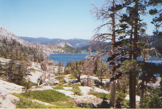
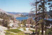
We took a cab back to the trail after a leisurely breakfast. A couple of miles in the woods brought us to Echo Lake, a small resort with a lodge and marina. Seeing the very full parking lot gave us warning that the Desolation Wilderness was likely to be crowded. It was. One thing we have learned: if you want solitude, don’t go to a Wilderness Area. EVERYONE likes Wilderness Areas! They’re almost as bad as National Parks. We passed dozens of dayhikers, dozens more backpackers either heading into the wilderness or heading out. Some take a boat for the first three miles across Echo Lake, but I enjoyed the walk above the water, seeing all the nice summer houses along the shore.
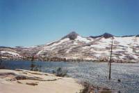
This was a lake day. While we passed several that we didn’t even see, we also spent a fair amount of time above or along the shores of Echo, Aloha, Heather, and Susie Lakes. Each was beautiful: dark blue, with sunlight sparkles, white granite cliffs and rocks, and sparse conifers. It was lovely. We decided on a short day. Jim’s feet are both hurting a lot, so a long day just didn’t seem smart. From here the trail climbs back into the snow. We had a few patches today, but nothing difficult as we were low and the land was flat. We’re above another large round lake. There are people camped nearby, but on a holiday weekend, that’s no surprise. They seem to be quiet, and so are we, so there’s no problem. The day was cool and very windy, but dry.
We’ll probably take this stretch a bit slower than usual. We have a midway stop at the home of a trail angel (Pooh) who hiked the AT in 1996. Jim is having a pair of pants shipped there from REI since his old pants are disintegrating. The mileage means we either push really hard to get to Pooh’s Corner in three days, or we can take our time and do it in four. Consensus seems to be that there is no real need to push. As thruhikers, we always hear the little nagging voice that says we have to go faster and farther, but we don’t always have to listen or obey. It’s hard to be passed all the time by other thruhikers, but it doesn’t really matter unless we let it. Five thruhikers appeared in town yesterday, totally new to us. We said hello when they stopped at the motel to see if there were any rooms left. They’re starting to catch up. Oh well.
Sunday, July 2: Bear Creek — 18.4 miles (1118.8)
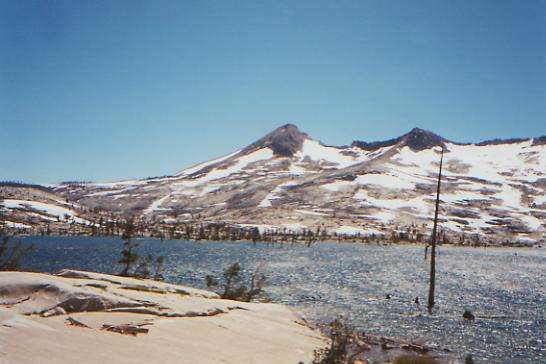
The wind kept us up most of the night, tearing at our tent as if it were trying to pull it apart. The Nomad held up well though. As a result of our short night, we got a late start. The wind made us stagger on our way up Dicks Pass, but it eased when we descended the north side. It was very snowy though, making navigation difficult for about a mile as we tried to spot and follow the switchbacks down below. We met a dozen or so people on the trail this morning, including two ultra trail runners, a forest ranger, a German couple, some dayhikers and various backpackers. One man was hiking the 150 mile Tahoe Rim Trail before going to work to help finish constructing it. We passed several pretty lakes, but left them behind as we headed out of the Desolation Wilderness. It was much smaller than I expected. I thought we’d be in the wilderness for a week, not just a day!

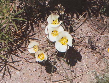
We’re back in trees for a while. They make for softer trail, but more blowdowns. We should see fewer people, I hope. There were rich fruity smelling ferns, lots of lupine, paintbrush and mariposa lilies, and deep dark woods. This afternoon, there were few views and only glimpses of two lakes, but the walking was mostly easy with very little up and down. We met a southbound PCT hiker who started at the Oregon-California border about a month ago. He said he has met only 13 other PCT hikers so far. That will change over the next three weeks. A group of dayhikers, heading south, were the only other people we saw this afternoon. That’s not surprising as there was little to attract casual visitors. We stopped near a stream with a good pool, just right to get a cold bath. For once the mosquitos behaved and let me wash up in peace. The stove is acting up, so dinner is delayed while Jim takes it apart. That’s the easy part. Putting it back together is what takes time!
Monday, July 3: Squaw Creek — 19.1 miles (1137.9)
A late start, an early stop, that’s the way to enjoy hiking. Squaw Creek is the last sure water for the next 15 miles, so it seemed like a good place to stop and call it a day, especially since there’s a nice large flat sandy area with views and lots of sunshine that is protected from the wind.

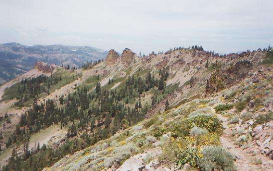
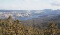
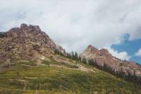
Today was a good day, though we were low on energy during most of the climbs. The day started and ended with good climbs, of course. A large part of the trail today was along or near the crest, with nice views east toward Lake Tahoe, south to the snow-covered Crystal Range, and north to Twin Peaks, Squaw Peak, Granite Chief, etc. Parts of the ridge were volcanic, with dark serrated rock formations. There were lots and lots of wildflowers, both along the ridge and in the green meadows below. Mostly we saw mule ear, lupine and paintbrush, but there was also columbine, mallow, candy tuft, mariposa, Queen Anne’s lace, etc. We passed a couple of ski resorts — Alpine Meadow and Squaw Valley. We were invited to use the heated swimming pool at Squaw Valley by its manager, but decided against it when it came time to actually leave the trail and go searching for it. I felt like we would be a bit out of place, in all our hiking dirt. We met the manager and his friends out hiking. They gave us some fresh apricots, about a pound of ripe cherries, and a bag of dried fruit. They were nice trail angels. Earlier, we met a PCT ’97 thruhiker named Dirk who now works in fishery rehab up at Crater Lake. He offered us a shower when we get there — if he’s home when we arrive. (NB — he wasn’t.) There were occasional patches of snow on the trail, but nothing difficult. The switchbacks on the north side of Granite Chief were buried in snow, but there were alternate routes around the steep banks. It was very cold and windy, and for a while I was worried about rain, but after a while the clouds cleared. It was pretty hazy — hard to see Lake Tahoe below, much less get good pictures, but then, that’s the way it’s been all through California.
Tuesday, July 4: Poohs Corner near Donner Lake — 12.2 miles (1150.1)
We had nice hiking along open ridgeline from Tinker Knob north. There were masses of dayhikers out enjoying the holiday. There was one really bad snowbank with very steep steps that scared me, but the rest of the morning was just rocky open hiking. It reminded us both of the CDT-- beauty on all sides. It was cold, but not windy today.
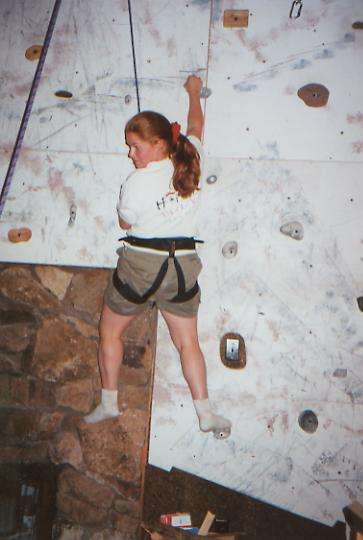
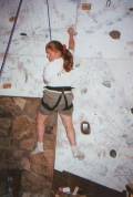
Bill Persons, a.k.a. Pooh, is a former AT hiker who opens up his home on Donner Lake to PCT hikers. He picked us up at Donner Pass, let us shower and do laundry, and took Jim to the grocery store. Rockfish, H, Molson and Tapeworm appeared later on. Bill has a two-story climbing wall in his living room, so we had the fun of watching four young girls, in harness, climb it this afternoon. One six year-old was really good. Later, Rebecca Williams came over. She hiked part of the PCT last year, before repeated sprains forced her off the trail. We knew her from the Internet, where she posted her trail journal. She and Pooh taught Rockfish the basics of wall climbing. He’s a natural, long and lean. Bill fixed us the perfect July 4th barbeque dinner: grilled burgers, chicken and salmon, corn on the cob, salad, potato salad, ice cream and lots of fresh fruit for snacks. Hiker heaven. He is a very nice man.

The local Sierra Club had left a cooler full of fruit and water near the trailhead for PCT hikers. That was a nice bit of trail magic. An unexpected day all around.
Wednesday, July 5: 22.1 miles — 1172.2
After a very filling breakfast and more interesting conversation, Pooh drove us to the trail about 8:25 a.m. The section between Highway 40 and Interstate 80 was surprisingly pretty and peaceful, filled with birdsong and sunshine — not like yesterday with all the chaos of rock climbers and dayhikers. The hike was mostly quite nice all day, with good views, occasional open ridge-walks, green meadows, some small snowpatches, and lots of forest. It is cold and windy though, with lots of clouds racing overhead. We stopped briefly to visit a Sierra Club backcountry hut, used during ski season mostly. I enjoyed the ladder up to the outhouse. The door was at least 10 feet off the ground. Appropriate in the winter, I imagine. We stopped early to fix dinner, as there was a long dry ridge-top section to end the day, then moved on from there. The walking was fast and easy. We met a trail crew fixing waterbars and a woman on horseback. Molson was the only hiker that we saw. He’s a very nice man from Alaska, retired, and as avid a bicyclist as he is a hiker. He hiked the AT a couple of years ago.
Thursday, July 6: Sierra City — 19.6 + 1.5 miles (1191.5)
It was a cold start, but the sun soon warmed us up as we climbed along open ridges and through sunny forests. We’re pushing a bit, in hope of arriving at Sierra City before the Post Office closes at 4:30. There were some nice views of tree-covered hills and the Sierra Buttes to the north, but most of the morning has been in dense forest. Most frustrating were the endless long switchbacks down to Milton Creek, where we stopped for lunch. It wouldn’t have been so bad except that not only did we not descend, the trail crossed several scree and talus patches that really slowed me down. This was not what we needed when we were hurrying toward town.
I’m not all that anxious to get to town for the usual reasons. After all, we just left Pooh’s Corner yesterday morning. But we have a lot to do at the Post Office this time, dealing with drift boxes and sending home our ice axes. It will be easier if we can sort and repackage our mail at leisure in a motel instead of trying to do it in a hurry on the steps of the post office in the morning.
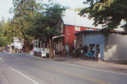
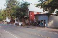
Later: We made it to town at 3:15 — that was pushing! Sierra City is very small — population 225! It is nestled in a narrow steep-walled valley, with lots of trees and wildflowers. Quite picturesque, in fact. There is a small general store, a couple of restaurants, and a couple of lodges or hotels. Ours is an old hotel above a bar and restaurant. It’s a quiet place. The restaurant is closed, and the few drinkers took their beers out to a bench in front. Dinner was good, but very expensive, and with a couple of the tiniest lamb chops I ever saw. But we didn’t have much choice. The restaurants are open at the whim of the owners, not on any set schedule, or so we were told. Molson joined us for dinner, and we had a nice time talking to him. Still, I’m glad we’re not staying over an extra day. Sierra City is way too expensive, though the atmosphere is casual and friendly enough.
Friday, July 7: Saddle at 1210.2 — 18.7 miles
We made a late departure from town after a good breakfast, a quick visit to the Post Office, a couple of phone calls, and a chat with Rockfish while I braided his hair. (Thick, long, and curly — am I jealous!) The initial climb out of town was an easy 1500’ of switchbacks on good trail through forest, but it was followed by another 1500’ climb on open slopes with lots of loose scree. It was interesting to see how the vegetation has changed. The land is really dry, so there is manzanita and live oak as well as the more usual high country White and Douglas Fir. We met a southbound PCT section hiker named Dudley, who is out for the summer. We chatted with him for quite a while. He was happy to meet thruhikers who were willing to take the time to visit. Most won’t take the time to say hello. I don’t know why they’re in such a hurry – we’re not.
The afternoon was gentle walking up and down along and around ridges. There were some great views of the Sierra Buttes, rising dramatically behind us, and of the many lakes around there. Above the lakes (and there were a lot of very pretty ones) there was also forest: dense red firs, some heavily logged sections, and some that had a lot of dead and downed trees — quite a mixture. It stayed cold and cloudy all day, but never rained. There were a lot of new wildflowers, including yellow lupine, which I’ve never seen before. I enjoyed today, despite the usual post-town malaise (ate too much, packs too heavy, ankle hurts, etc.)

We lost Molson and Rockfish at the side road up to the fire tower. As interesting as it looked, I really wasn’t in the mood for an additional 1400’ climb, with an extra three miles added to the day. So far, I don’t regret sending home our ice axes. It was nice to lose the extra pound off our packs. We had only one big snow patch, and it was flat. There are some weekenders camped on the other side of the pond, but they seem quiet and friendly.
Saturday, July 8: Chimney Rock — 24.5 + 0.25 (1234.7)
Heavy dew soaked us overnight, so lunch was in a sunny spot by a small creek where we spread out our tent and sleeping bags to dry. It was a somewhat frustrating morning, with lots of winding trail, blowdowns, snow patches, and heavily overgrown stretches to slow us down. The forest has huge tall trees, and there were some nice views early in the day. It’s very peaceful, with constant birdsong, blue skies (at last!), butterflies, and frequent side streams not listed in the guidebook. This afternoon is supposed to be dry as we wind westward back up on the ridge. I’m a bit worried about doing big miles through here. I feel like we have to because of the Post Office situation. In Belden, the PO is only open 9-12 M-F and in Old Station it is only open from 12-2 on Saturday, the day we were due to arrive. If we miss either we’ll be stuck in Old Station until Monday. So we’re trying to do 92 miles in 4 days. Yesterday’s late start meant we only hiked 18 miles. With today’s late start (8:00!) it will be very hard to do the 26 miles we had planned. I hate feeling pushed like this. It makes me grumpy and very impatient with every extra unnecessary switchback or dead tree. There have been a lot of those, and a surprising number that we’ve had to crawl under. Jim lost his glasses at one of those yesterday. We went back and found them, only a little the worse for wear.
The afternoon hike had less up and down, but fewer interesting views. We did a side jaunt to get water and decided to cook at 5:00, then keep hiking until 8:00. We didn’t make the 26 miles, but then, since we had water, we didn’t need to. We’ll make it to Belden, one way or another. Old Station is still uncertain.
Sunday, July 9: Creeklet at 27 miles (1261.7)
Another warm and sunny day. The morning was spent mostly descending to the Middle Fork of the Feather River, while the afternoon was spent climbing back up. It was a 3000’ elevation change in each direction. It was a rather nondescript morning: no views and lots of overgrown trail. There was one stray guy on a bicycle out where he had no business being. They aren’t allowed on the PCT, though there are few signs to that effect. Jim and I were too surprised at seeing him to say anything. Given how bad the trail was, he may be sorry he didn’t stick to the jeep roads. We saw a sign saying the PCT was closed because of fire danger, but since it was dated last August, we assumed it was no longer in effect. Part of the trail was badly burned above the river and along another stretch that we walked later in the afternoon, so there obviously was a real problem through there. There was a wide variety of vegetation as we climbed this afternoon and as we rounded the ridges to areas with more or less sun. What surprised me the most was seeing maple saplings, dogwood, and daylilies. One of the dogwood trees was still in bloom. A young rattlesnake with big brown spots hurried off the trail as we approached, as did a big garter snake. We ended up going farther than expected. We got water at a creek, then couldn’t find a good campsite so we kept going and going and going. First we were too close to a road, then we were in a buggy meadow, then in a fern forest, then the trail was narrow sidehill on a steep ridge with nothing flat for about two miles. Finally we created a small “desperation” site downhill from the trail. According to the map, the next three miles are the same kind of steep country, so we were glad to find even this not-so-flat spot. Until the end, we were doing well. The views from Lookout Rock weren’t exciting, but at least there were views. The fire damage and clear-cutting were very evident, but mostly we saw tree-covered mountains spread out for miles. We met two dayhikers, but no other backpackers.
Monday, July 10: Belden — 21.4 miles (1283.1)

It took a while for our sore feet to quiet down (they talk to us when we overdo it) but eventually we slept, despite the lumps in our narrow campsite. The morning hike was pleasant, with easy contouring around a mountain, followed by a gentle climb up Spanish Peak, then easy up and down with nice views eastward. There were lakes below us and occasional meadows, with lots of lupine and other wildflowers. The afternoon was less interesting as we made a long descent into Belden, a small “resort” with a few cabins, trailers, a small store, restaurant, and saloon, plus a laundromat and shower. Just what we hikers need! We reached Belden around 4:00, where we met Brad, Kathy, Tak and Allan -- a section hiker who started just a week ago. Brad is waiting for his girlfriend to join him for a couple of months on the trail. It’s kind of a hard stretch to start a long hike. Molson strolled in about an hour later. We all ate dinner together, except Tak who was fishing. He’s a Japanese hiker who started at Kennedy Meadows. It was a hot day, but mostly pleasant. The long descent (3500’ in 5 miles) was fairly steep, but shaded. Worse was the poison oak along the trail. I know I react to poison ivy, and Jim is very allergic to it, so brushing against it constantly is worrisome. There’s no way to avoid it though when the trail is overgrown. We met two maintainers along the trail, cutting blowdowns. Unfortunately, few maintainers seem to bother with the brush out here.
Home | Links| Trail Journals |
The Thruhiking Papers | Bun-bunSouthern California | Central California
Northern California | Oregon | Washington
Created: Fri, 16 Jan 2004
Revised: 30 Sept 2016Copyright © 2004-2017 Spirit Eagle