|
|
|
 |
 |
 |
 |
|
|
|
|
|
|
|
|
The Pacific Crest Trail
Belden to Castella/Mt Shasta City
Tuesday, July 11: about 14.5 miles (1297.6)
We had an adventure today, and a nasty uncomfortable thing it was too! We knew there was a washout on the trail and that the forest service had created an alternate route out of town to avoid the problem. We heard also that the old trail was still passable; you just had to work your way around the gully. So, we decided to do that instead of the safer, longer, dryer alternate route because we had to go to the Post Office, which is a mile out of town and near the old trail. We decided to avoid backtracking that mile. Bad idea! The first eight miles out of town were fine. Then we reached a very deep, very wide gully -- the washout. Going down was an option, but we couldn’t see any sign of the trail on the far side, and it was a couple hundred feet down on loose scree to where it looked safe to cross, so we decided to follow footprints uphill instead. Trouble was, we weren’t where we thought we were. The map showed the trail switchbacking across a canyon. Wrong canyon. We were at a different canyon, but didn’t know it. Instead of a short steep section followed by a long not so steep climb up to the trail, it was 2000’ straight up to the top of the ridge. Not so straight actually. We did a mix of wading though thick brush, climbing hand over hand up rocks (shades of New Hampshire) and dodging from tree to tree on loose scree. It was long, hard, scary, and exhausting. Kathy was hiking with us. She and I were both wearing shorts, so we got badly cut up, as did Jim’s hands and arms. Trouble was, the rock was “rotten” and would break off in our hands or under our feet. We couldn’t trust it at all. The manzanita was safer, though it scratched us up badly. At one point, after a couple of hours of climbing, we thought we were really stuck. We stopped on a narrow rocky ridge, saw rocky cliffs ahead and to the right, and a long scree slope to the left, dropping to a ravine. What to do? We dropped, very carefully, then climbed up the streambed. It worked, but it wasn’t easy. It took 3 ½ hours to get up to the ridge, where we met the alternate route, a jeep road that we followed back to the PCT and the spring where we stopped for the night. We were all utterly exhausted and hurting. We were dehydrated too, as we almost ran out of water along the way. Mosquitos are pretty bad around the spring, so it will be an early night for us.
Wednesday, July 12: Dry gully between Butt Mtn. And Soldier Creek — 24.2 (1321.8)
We didn’t sleep well, due to sore feet, but we still got a good start at 7:00 a.m. Kathy went on ahead. She hopes to reach Old Station on Friday. That was our plan too, but yesterday’s low mileage probably blew that. The Post Office is closed on Saturday, we discovered in Belden. We have a drift box there, but we can probably forward it and buy in the store instead.
The morning hike was mostly easy up and down in heavily logged forest. We filled up at Cold Spring as the next water is 23 miles away. That was a gushing piped spring, very nice. Six miles later we saw some pick-up trucks and horse trailers at a trailhead, and a sign that said, “PCT Hikers — free fruit and water.” The Backcountry Horsemen of California had left a box of delicious nectarines and a big jerry can of water. Terrific. We took a quart of water and a couple of nectarines, then moved on — in the wrong direction, unfortunately. We missed a turn, climbed up an old logging road, then had to backtrack. Oh well, we didn’t go that far. There were nice views of Mt. Lassen and Brokenoff Peak, various volcanic rocks and ridges, green forests and hills, and a couple of big lakes to the east.
Mid-afternoon we met two horsemen out cutting blowdowns. We chatted with them for about half an hour, then moved on. (We maintainers have to stick together!) We decided to stop early, due to sore feet and a nice campsite near the trail. Looking at the maps, we saw that the terrain steepens again for the next few miles. We’re still four miles from the next creek. Doable, but it would kill our feet, and there’s supposed to be limited camping there. Kathy probably has the one site already. She’s welcome to it. One nice thing about dry camping — no mosquitos! There are, how ever, yellow flies. So far, they don’t seem to be biting though.
Thursday, July 13: Warner Valley Campground — 27.2 miles (1348.1)
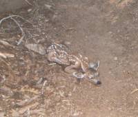
We slept well in our piney glen, then dropped down to the spring to fill up our water bottles. The walking was easy, so we made 14 miles by lunchtime. The best moment of the day was seeing two newborn fawns on the trail. One tried to hide by lying down and shutting its eyes. Unfortunately, it was right in the middle of the trail. Jim almost stepped on it. The other was standing, barely, and it wobbled off the trail a few feet. They were so tiny, and so cute! Mama doe hid in the trees, out of sight. Later on we had the fun of cooling our feet in the Feather River - nice!
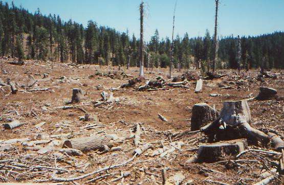
Less appealing was running into a logging operation beside the trail. We heard the saws and machinery before we got there. They didn’t actually cross the trail, but they cut trees along it and on both sides, then drove the heavy tractors in to pick up the downed trees. It was selective cutting, but still made a mess. I was surprised (and unhappy) that they were allowed to take trees right along the trail itself.

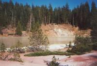
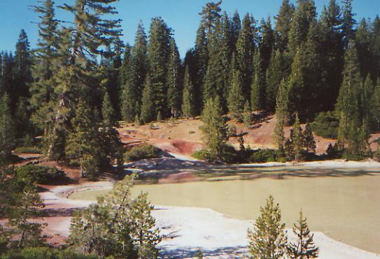
We ended up at a public campground in Lassen National Park. It’s half empty, which is surprising for a National Park, and seems very quiet. We didn’t have the heart (or the feet) to climb another 2 ½ miles to the next camp area. The afternoon had a lot of up and down — a real roller coaster. As soon as we entered the Park, the trail changed. National Forest trail is quite different from National Park trail. Surprisingly, the National Forest trail is better — or at least easier. They don’t generally put the National Scenic Trails through National Parks along the more popular routes (except for the JMT in the Sierras and the CDT through Glacier.) Instead we get the areas no one else wants to visit, usually for good reason. Oh well. The highlight today was Boiling Springs Lake — a big thermal pool. That was interesting. The rest was just bad trail in the woods.
Friday, July 14: Old Station — 24.7 miles + 0.3 (1372.8)
We didn’t really expect to make it to the post office before they closed today, but somehow the miles just rolled by. We left Stephanie and Rich, two section hikers we invited to share our campsite last night, still asleep as we took off in the early morning light. The rest of the stretch through Lassen National Park was a disappointment. There were no views, the trail wasn’t maintained and had lots of blowdowns and some bad swamp, and there was only a glimpse of Swan Lake and a short stroll around Lower Twin Lake for interest. There was an alternate route past some lakes that would have been more scenic, but slower because it is buggy and boggy, according to the guidebook. We should have taken it. The one advantage of the official trail is that it was quick and easy walking, for the most part, but it was boring.
We reached the Old Station Post Office at Hat Creek Resort around 3:30, after a long gentle downhill cruise through dry forest, manzanita, and sage. Part of the forest had been strip cut: totally bulldozed in strips about 10 yards wide, alternating with strips of trees. There were 13 of those strips across the trail. Weird — and ugly too! Anyhow, we got to the Post Office and found goodie boxes from Blake and Linda as well as the drift box that we repacked and mailed ahead. We took a shower, bought bread, sodas, and ice cream from the gas station mini-mart with an incredibly friendly manager, and finally had dinner with Kathy and Allen, who were both settled in at the motel. Jim and I decided to walk on another mile and camp in the pines, though the full moon makes the idea of a night hike almost appealing — though maybe not after 25 miles. It is nice to be clean, sort of, and well fed. An owl is circling overhead making strange noises, “whuff, whuff!”
Saturday, July 15: Beyond Hat Creek Rim — 29.5 miles (1402.3)
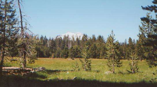
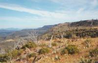
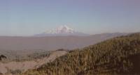
We had a peaceful night in our little bower between Hat Creek Resort and Old Station. We started out early, hoping to get breakfast at Old Station, a couple of miles up the road, but one restaurant didn’t open until 8:00 and the other was closed due to a family wedding. So we sat at a picnic table and ate cold cereal. A very nice lady let us get water at the closed ice cream parlor and gave me a cup of coffee. We climbed up to the Hat Creek Rim, an escarpment 600-1000’ above the valley. The trail follows the cliff edge for more than 20 miles. There were beautiful views of Mt. Lassen and Shasta, plus several other volcanoes. The main problem was lack of water — there is none for almost 30 miles. Our packs were very heavy with the 6-7 liters we were each carrying. A fire in 1987 burned about seven or eight miles of the trail, so we were out in the hot sun most of the day. Even where it wasn’t burned, the trees were sparse. Mostly the area was high desert: manzanita and sage, pinyon and Jeffrey pines, lots of thorns and grass seeds. The rock was dark volcanic rock, but up on the rim the walking wasn’t too bad. Once we descended, we reached a more recent flow and the rocks really tore up our feet. It was interesting—very like the Malpais in New Mexico—but difficult. Worse was when we began looking for a place to camp; we couldn’t find one. The ground was covered with lumps of lava. We had to keep going and going until the lava thinned out.
We met two southbound section hikers—Ant Newman and Liz. I had read his journal on the Internet and found it a good read. He’s an Englishman, while she’s from Bend, Oregon. They only hike about 15 miles a day, so section hiking works better for them than thruhiking. They can relax and have fun, instead of having to push to do the miles to finish in one year. It was fun to talk with them.
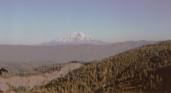
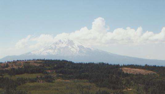
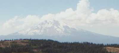
Tonight we’re tired, sore, dehydrated, and filthy. I doubt we’ll sleep much, but at least we’ve finally stopped walking. We’re still a couple of miles from water, but we have enough for the night. I enjoyed the walk along Hat Creek Rim more than I expected, despite the lack of water. The views more than made up for the difficulty, though, as usual, the trail wound around a lot more than was necessary. I loved seeing Mt. Shasta. It is a classic snowy volcano, just like Fujiyama. We’ll be circling around Shasta for the next 300 miles. It’s beautiful.
Sunday, July 16: Burney — 7.6 miles (1409.8)
We packed up quickly, without stopping for breakfast, and made it to a creek about an hour later. Jim and I sat down to filter a few quarts of water, ate some cereal, and drank as much as we could. We had arrived with one pint between us, just in case. That isn’t bad after 30 dry miles. One hiker Ant and Liz met had run out completely after 15 miles. Allen showed up as we were repacking, but we passed him soon after. We didn’t go far today. Since we have gotten ahead of schedule, thanks to pushing to reach the post offices in Old Station and Belden, we decided to take a day off in town. We’re both exhausted. We walked to the highway--about eight miles up the trail--and hitched into the town of Burney. It was nice walking, through live oak and pine grasslands. We passed a fish hatchery and a lake, with ducks and pelicans. Soon afterwards we saw an osprey on its huge nest. Actually, we heard it first, then looked up to see it above us. It flew off, and soon we heard and saw two of them circling overhead. That was exciting.
Getting a ride to town took about an hour, but was worth it. Everything we need is right in one spot: motel, laundry, store, and restaurants. We’re both surprisingly tired. We’ve done a lot of miles in a short time, and despite the frequent stops (Belden and Old Station) we haven’t had a real break since South Lake Tahoe, 300 miles back. Food stops are great, but they aren’t the same as a day off.
Monday, July 17: Burney -- Day off
Tuesday, July 18: Peavine Creek — 21.8 miles (1431.6)
We ended up taking Monday off in Burney. We were packed and ready to go, but still so tired we could hardly see straight. So we got another room at the motel and settled in for a quiet day of reading and watching reruns on TV. We got a ride out of town fairly quickly (1/2 hour) with the principal of the Christian Academy next to the trail. Nice man. Oddly enough, at the same time he stopped, another car turned around to pick us up, driven by the guy who gave us a ride on Sunday.
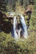
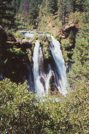
The seven trail miles to Burney-MacArthur State Park were utterly forgettable — just flat winding through scrub forest. The waterfall at the park, on the other hand was very memorable. It was probably the prettiest waterfall I’ve ever seen — and I’ve seen a few! It drops 129’ with a volume of 100 million gallons a day. Seems like a lot to me, especially when you consider that the water comes from underground springs not far upstream. We met a new thruhiker, Tim, at the snack bar, where we drank soda and ate ice cream while ignoring the hordes around us. The PCT doesn’t actually go to the falls, so it was a bit confusing trying to find our way back through the maze of trails, but instinct steered us right. The trail later goes past green Lake Britton and over its dam. I enjoyed seeing the lake, once I realized that the steep trail down to the base of the dam was not the PCT after all. It went straight down! It was nice to be away from the crowds at the park and back in the quiet of the woods. I’m not sure I was quite ready to be back on the trail, but now that I am, I’m content. We shouldn’t have to push too hard for the next few days. No big water problems, and plenty of time to reach Dunsmuir, our next mail-drop, by Friday.
The afternoon was spent climbing gently through changing forests. We had dry live oak and manzanita for a while, then dense firs. The highlight was taking a quick dip in Rock Creek mid-afternoon. I was so hot and dry! (It’s in the 90’s today.) The water felt cold and wonderful, and made the next three hours much more pleasant as my clothes gradually dried in the breeze. We’re at a big campsite off trail a bit, much used by hunters and car campers, with tables and hanging bars. The creek is dry here, so I had to search downstream to find water. It was a bit frustrating since I had to keep going back and forth over the same stretch of road over and over. We’re a bit tired, but don’t feel too bad for a 22-mile day. It’s easy trail. We met Allen walking the other way, heading for Berkeley and a new pair of boots. Tim is camped back by the road. He was already settled in when we passed by.
Wednesday, July 19: Grizzly Peak Road - 24.8 +1.0 (1456.4)

I understand why so many people are anti-logging; what a mess they make! We passed through a lot of logged areas today, some lightly cut, some completely bulldozed. We crossed logging road after logging road. Sometimes finding the trail was difficult where a bulldozer had cut across the trail. Elsewhere we had the opposite problem: brush and saplings had grown up to completely bury the trail. We had to feel our way with our feet. In one place, the loggers had dumped cut branches back onto the trail. Thanks guys! All in all, it was not a good morning. We only walked about 10 miles before lunch because the going was slow. We did run into a Forest Service trail crew — three people — so the next mile or so should be better. That was in an area of total devastation. Without their efforts we would not have been able to find the trail at all, thanks to bulldozed ruts everywhere. We saw one deer, plus lots of white and orange lilies, orange columbine and paintbrush, blue larkspur and penstemon.
The afternoon was a bit better, though we never did get much energy. There were some good views north to Shasta, south to Lassen, and of all the green hills around us. We decided to cook dinner and move on a couple of miles, both because there are no good campsites near the water source (a tiny pond) and to make tomorrow a bit easier, we hope. We’re both tired and sore, but willing to do a bit more. We walked for a mile or so on an old dirt road that parallels the trail for 22 miles. Partly it was rebellion against the trail, partly it does cut a little distance off the side trail to water, and partly I hoped it would be less overgrown than the trail. (It wasn’t.) Oh well, we did find water, and that’s what really matters. There was a really cold spring today that was almost too cold to drink. Earlier we got snow from a big drift to ice off the water in our water bottles. Odd to see snow when it’s 90°!
Finding the trail again after dinner was actually harder than finding the pond, and finding a campsite was harder still. The trail was on the south side of the ridge, wandering through dense manzanita. There was no place to go to find a clear spot to sleep until we reached a jeep road. Then we set up our tent in a small parking spot along the road. It doesn’t look like it gets much use, and it’s either that or the trail itself. We’ve seen bear sign, so don’t really want to be blocking the trail if we can avoid it. I hate getting run over by creatures that weigh more than I do!
Thursday, July 20: Squaw Valley Creek — 27.1 miles (1483.5)
Our wide spot in the road turned out to be a restful campsite, once we put up the tent to keep out the mosquitos. They were hungry! We left at 7:00 a.m., climbing the jeep road to Grizzly Peak. Though longer, that alternate route was preferable to the overgrown segment of trail we passed, and the views were supposed to be better. It was too hazy for pictures, but still it’s nice to look out over the green ridges below. Last night was really good for views as we hiked until it was almost dark. I love the late evening light with all the blue and purple shadows.
From the peak, we descended all morning to the McCloud River. There were lots of side creeks. I fell in one, thanks to a slippery rock. It cooled me off, anyway. We saw a deer and a snake that looked like a coral snake, but was probably a king snake, its harmless cousin. It was black, yellow, black, red, black, yellow, black, etc. The colors were framed in black. It was a different one anyway.
I dipped my legs in the river at lunch, trying to cool off. The water was too cold and flowing too fast for a real swim, but it did feel good. The trail has been mixed: overgrown in many places, dangerously narrow in others, and sometimes wide easy cruising trail. The vegetation is mixed too, with some oak forest and some pine groves. It’s very dry. We climbed for most of the afternoon, then dropped again to a couple of creeks. There was no place to camp at the first creek, a small site half a mile later, and a big camping area at the third creek three miles further on. Guess where we ended up? We’re very sore and tired, but happy to stop. I took a bath in the creek. It was cold but wonderful. We passed a couple of weekenders and said hello, but didn’t stop to chat. Jim scared a big rattlesnake, a Mojave Green. It went off trail and coiled up under a log, rattling at us. The trail was badly overgrown all afternoon — deer bush and saplings mostly — with a bad infestation of poison oak. I may already be infected; I’ve had a rash on my legs for a couple of days. It doesn’t itch much, but it looks a mess. Though poison oak has never been a problem before, the rash could be an allergic reaction to it or something else. Or it could be just too many mosquito and ant bites. I’ve had more than a few of those. It was really hot today — mid to high 90’s — so shorts were a necessity, especially for the climb, but we may pay for that tomorrow. The woman we passed looked at our bare legs and asked, “Don’t you have a problem with the poison oak?” “What poison oak?” “Oh, you mean the last ten miles of trail.” We laughed. What else can you do? The oils will get on you, one way or another, either on skin or on clothes. It’s not like we can take a bath and put our dirty clothes in the washing machine any time we want.
Friday, July 21: Mt. Shasta City — 16.9 + 3.0 (1500.4)
It was a long day, rushing to get to the post office in Dunsmuir before it closed at 5:00. This was made harder by the fact that there’s no easy way to Dunsmuir. It’s 4 ½ miles from the trail, which we did partly by walking illegally on the freeway, then we took to the rural roads. We got a ride the last couple of miles. Most PCT hikers go to Castella, a small village closer to the trail, but we heard that Dunsmuir had more services so we chose to go to the bigger, but farther, town. Then we decided to complicate things still further. Both our boots are starting to fall apart, so Jim and I decided to catch a bus to the next, and even larger, town, Mt. Shasta City, which has an outfitter. We got there six minutes after the store had closed. Oh well. We walked back up the road a mile or so to a motel, where the hot shower was the highlight of my day. We did our grocery shopping in Dunsmuir, so all that is left is laundry and dinner. Then we can collapse. The town has lots of bars with live music, a decent bookstore, and the Black Bear Diner has hiker-sized portions – a good place to visit, all in all.
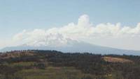
We had a nice walk in the woods this morning, despite the rush. An easy gentle climb was followed by an even easier gentler descent. It was too gentle, but that’s another story. Wheelchair trail again. I was glad for the early start as it meant we were climbing in the shade, for the most part. There were some nice views of Mt. Shasta and Castle Crags across the valley.
Home | Links| Trail Journals |
The Thruhiking Papers | Bun-bunSouthern California | Central California
Northern California | Oregon | Washington
Created: Fri, 16 Jan 2004
Revised: 30 Sept 2016Copyright © 2000-2017 Spirit Eagle