|
 |
 |
 |
 |
|
|
|
|
|
|
Monday, October 18 - 18 miles to Lagunitas Creek
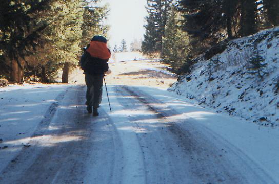
We had a very restful day on Sunday. We woke up exhausted, with no desire to start hiking again, so we decided to stay over and take it easy. We ate breakfast at the lodge, watched a movie on TV (Around the World in 80 Days), ate lunch, read the newspaper, made a few phone calls, ate dinner, finished my book and slept. Now were rested and ready to face a 7-8 day section of wintery weather. Despite the bank of black clouds that was parked over the mountains on Saturday, not much snow fell on the Osier Mesa - only 2-3 inches. A lot more fell east and south of here. The news was full of stranded campers and 12" snowfall. The forecast now is for continued cold, with another cold front to pass through tomorrow. Night time temperatures will be around 10°, supposedly.
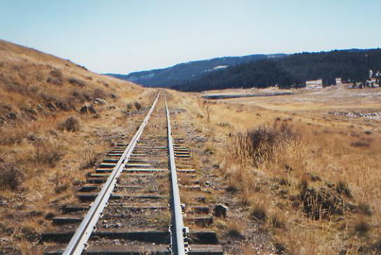
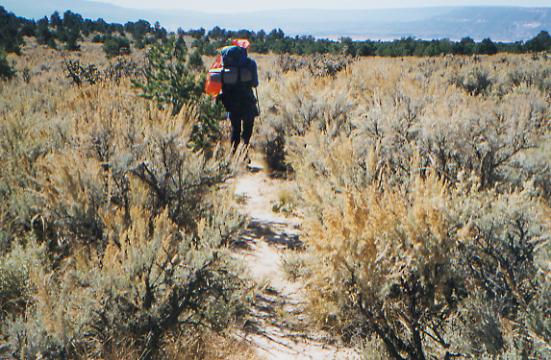
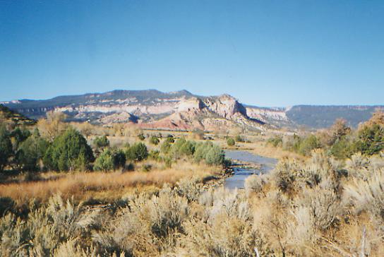
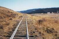
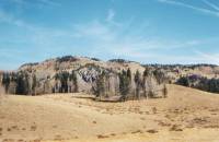
We got a ride from the motel owners back to Cumbres Pass, then followed the railroad tracks south for a while, then a forest road into New Mexico. Well follow this road for a long way. We climbed through dense forest up to the plateau, which is mostly open grassland with scattered spruce. The snow is patchy, but there are views of a heavily snow-capped range to the northeast, probably the Sangre de Cristos Range. Weve seen a couple of pick-ups, but mostly its pretty quiet with just a gentle wind blowing. The sun is shining but has little warmth.

LATER: an easy day all in all, almost entirely on jeep roads. It was pretty country, and we saw three elk running across the road. At one viewpoint, I was hit by a sense of irony--as I looked at the beer cans scattered around, I imagined some guy sitting in his truck, looking out at the Las Cruces Basin Wilderness spread out below, muttering, Nice wilderness as he tossed his beer cans out the window. People are strange.
We saw lots of hunters and hunters camps today along our roads. There were more people today than we saw all week in the backcountry in Colorado. One man asked how far wed come, and when we told him he said, I thought so, you have the look. (And here I thought we looked pretty good after two showers in town!)
Jim: We finally got out of Colorado today. It was interesting, beautiful, cold - and lots of elevation gain/loss. Funny thing - in spite of Colorados beauty, I still prefer Wyoming. Im not sure I could say exactly why, but thatll come in time. And I was so anxious to leave Wyoming.
Tuesday, October 19 -- 21 miles to Long Canyon
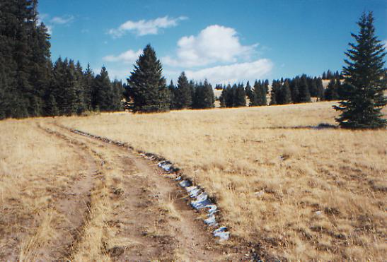
It was an easier bushwhack than I expected this morning as we followed the Tierra Amarilla Grant fence line for about six miles. There were a couple of steep gullies, but mostly it was easy walking on the plateau following cow paths. While there are scattered trees and groves, a lot of this area is open grassland, heavily grazed, which makes for easy walking. Im glad we decided to follow Jim Wolfs route through here. Weve seen no sign of Jason and Julian, so they must have followed the highway out of town. This is pretty, even if it is longer.

LATER: The afternoon was mostly spent following closed jeep tracks. There was a bit of confusion when we were dumped unexpectedly on the highway two miles sooner than expected, but we just followed the road until we were back on track. There was confusion again when the description and reality didnt quite mesh. We didnt think we were lost, but it wasnt certain. We followed a twisting valley for a couple of miles past three cabin ruins on an old jeep road. Mostly we just went up and down along valleys and over ridges. Our most interesting view was of the Brazos Box, a very steep canyon to the east. I had noted it on the map, and was curious. We could barely glimpse Heron Lake on the other side of the notch. The only other real highlight was the rocks. In one area they were purple, or purple, blue and white. Others I noticed were pumice-like volcanic rocks and a lot of quartz. No people or wildlife so far today. We had a hunter on an ATV pass by last night as we were eating dinner. Thats the trouble with being near roads. We were well off the main road, but that little faint track was enough for an ATV to follow.
Jim: I guess New Mexico wont be a lot warmer than Colorado. Were still at 10,000+ ft and it snowed up here yesterday. Other CDT hikers have commented on how the country changed to New Mexico desert after Chama, but they werent following Jim Wolfs route through the high country. A lot of thruhikers do the road-walk between Chama and Ghost Ranch through the Tierra Amarilla, but Jims route skirts the entire land grant. And its a lot prettier than the road-walk, or at least, more wild. And at higher elevation.
Wednesday, October 20 - 18 miles (Elev gain/loss: +4780/-4050)
We had another bushwhacking morning, following cow paths and game trails around private property. It wasnt as difficult as I feared. Even the nasty bushwhack mentioned in the guidebook, up Jarosita Canyon, wasnt bad. It was fun using the compass to guide us up the ridge. We were able to boulderhop the Rio Vallecito, which is good as the water was very cold. After a very cold and sleepless night, the day has warmed up nicely. (We were facing north again, which often seems to affect our sleep. I have no idea why, but its not just superstition.) This afternoon should be easier, following jeep trails through the woods past an area called Fifteen Springs. We were slow this morning due to a few confusing sections: Are you sure we go over this snow covered rock pile? Doesnt feel safe to me. Lets go around. Also with the warmer weather, our breaks get longer. We spent 20 minutes watching the activity at one of the ranches as they loaded ATVs on a trailer and took off. Vallecito Ranch is a game preserve and possibly a camp or retreat center. We saw a lot of buildings as we wandered around the perimeter. There were some dramatic cliffs, but mostly we walked through woods or out in the meadows. At the first ranch, it was frustrating to be bushwhacking along the fence, when just on the other side was a nice smooth, straight jeep road. We followed it for about 3/4 mile, despite the no trespassing signs, but I got too paranoid about getting arrested, so we crossed back to the National Forest side of the fence again. We did miss some nasty rocky PUDs though. (PUD=pointless up and down.)
LATER: We ended up doing more bushwhacking after all, following a short-cut mentioned in the guidebook. It cut off a mile and about 500' of climbing, but still meant a lot of up and down through blowdowns. The afternoon was spent following old obscure jeep roads. Best was seeing bear tracks in the snow. It was a big one. We saw two jeeps this morning, but no hunters in the field and no wildlife. Just lots of pretty forest and meadow.
Thursday, October 21 - 18 miles to the Arroyo del Yeso (Elev gain/loss: +1540/-3110)
A mixed morning, with a couple of miles of bushwhacking through aspens and meadows, followed by an alternate route chosen to avoid more bushwhacking that turned out to be a very nice choice. FR 724A climbs the western side of Mogote Ridge and has nice views west toward the white cliffs above the Chama River. Were in scrub grassland with our first pinon pines and scrub oaks mixed with the aspen. Colors are subdued: blue hills, yellow grass, grey aspen groves, dark conifer forest. Something is spewing smoke, which creates a grey haze along the horizon. It looks like the plume from a power plant. We saw a couple of black cows, but no wildlife. This alternate route goes through private land, but seems to be open to the public. Hunters use it regularly: beer cans were everywhere. There were a few cabin ruins and a piped spring, which makes this a good alternate route.
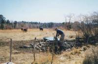
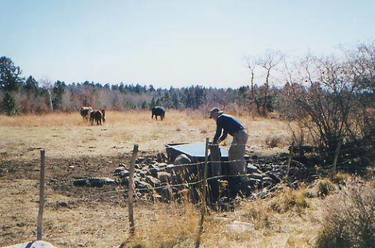
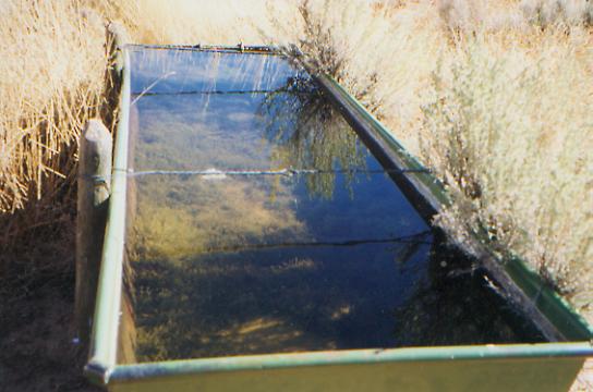
LATER: We followed more jeep roads through forest and scrub and only had a short bushwhack from where one logging road ended to the forest road half a mile below. Were in a two day break between hunting seasons, so the roads were deserted. We did see lots of cows, and had a funny encounter at the Harris Bear Spring. Its a good one, with a pipe and a metal trough, not just a large puddle. A bull, with a cow and two heifers, approached the spring just as we were heading there to fill up for the night. There was barbed wire between us, which made me feel a little safer since the bull wasnt about to give up his turn at the water. When they were done, they stood watching us. We shooed them off and Jim slipped under the fence. Just as he finished filling the bottles, along came the rest of the herd, including several longhorns. We packed up quickly and left them to their afternoon watering.
Part of the hike was along a ridge, covered with Ponderosa Pine, with nice views toward the Abiquiu Reservoir and the mountains to the south. It would be a good place to dry camp, but we wanted to put in another couple of miles, so we bushwhacked down the ridge to the jeep road down below where there is a nice campsite, covered with beer cans. Mr. Bud Light strikes again. Weve followed Budweiser cans all across northern New Mexico, including a few hundred deposited by one guy who drank Bud Light and crushed the cans in the same way every time. We joke about it, but it is also really depressing to see the mess.
Jim: Ive actually managed to not mention the Bud Lite man before. But Ive been REALLY irritated by the prevalence of trash since we got into New Mexico. The Carson NF is the worst weve seen on the entire trail. We followed one guy for about 16 miles tracking him by the distinctively broken beer cans. That deserves a letter when we get off the trail.
Friday, October 22 - 17 miles (Elev gain/loss: +1750/-3950)
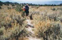
It was a very frustrating morning. We mislaid the directions (hidden in the bottom of our sleeping bag) so from the time the road ended at the Arroyo del Yeso, we were lost. We bushwhacked down to the bottom of Yeso Canyon on occasional game trails, then found an old road. We turned the wrong direction, into the canyon. We climbed on the road up to the plateau on the other side, then tried several ways to get back down to the canyon bottom. We twisted and turned and got rim-rocked three times. Finally, we backtracked on the old road, turned the other direction, and it was immediately apparent that that was the right trail. It was still rough, but there were cairns and it was obvious it got some use. We wasted two hours and experienced a lot of frustration trying to find it. The area is pretty, with multi-colored sandstone cliffs and high desert ecosystem. The sage is lush waist high and were seeing our first cactus since Wyoming: prickly pear, cholla, hedgehog, pincushion, yucca and agave. The trees are mostly juniper and piñon. This whole week has given us a tremendous variety of ecosystems, from alpine to desert. Ive enjoyed it, despite the bushwhacking. (NB: the directions wouldnt have helped. JW bushwhacks too, down to the bottom of the canyon. And it was remembering his directions to cross the canyon that got us really lost. Trouble was, we did it farther down the canyon than he did. The trouble with bushwhacking in dense cover is that its hard to know where to come out.)


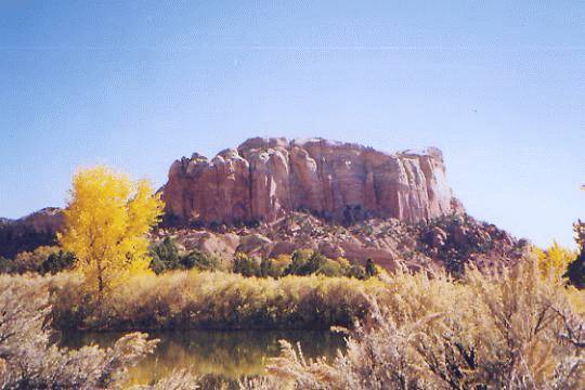
LATER: Were camped by the Chama River, watching the almost full moonrise over the hills. The land around here is beautiful, with multicolored cliffs and hills. It is still autumn in this low country, so the cottonwood trees are yellow and the grasses are shedding seeds right and left. My socks are a solid pincushion. Our visit to Ghost Ranch was brief. We picked up our maildrop and sorted it, drank two cokes apiece, then left. The main part is a conference/retreat center, quite large, in a superlative setting, surrounded by dramatic sandstone cliffs. Funniest part was a woman who passed by as we were sorting our mail. She looked at all the candy bars, cookies and granola bars on the table and laughed, A childs idea of heaven. There is a nature walk from the main buildings to the Living Museum, an attempt to copy the Sonora Desert Museum in Tucson, but on a much smaller scale. I learned a few plant names along the nature walk. (i.e. Winterfat is a pretty silvery plant with a cottony head right now. Very pretty!) The Living Museum has been closed since July for renovations, so we headed across the desert toward the Chama River, partly on jeep tracks, partly bushwhacking, then followed a winding dirt road. We saw lots of jackrabbits and a few cars. There was an odd line of stones, cut blocks, in the ground near the fenceline. It was only a couple of inches above the ground, but extended for about a mile. We wondered what it was--a fancy boundary line? It wasnt straight. We also saw a ruined adobe house in the canyon.

This was the first day that really looked like the New Mexico I expected to see. The high country was beautiful, but kind of generic. We could have been in Colorado, Wyoming, or Montana just as easily as New Mexico. But the colored cliffs and desert are different. Now I really feel like Im in New Mexico.
Jim: Now the country has changed to what we expected New Mexico to be - desert. The trail was rough, but beautiful coming down off the forested ridge to Ghost Ranch, then it became desert. Ghost Ranch was somewhat of a disappointment, but not greatly so. They had a conference in progress so there were no rooms or meals available, but they did have our maildrop. They also had Coke and snack machines. And rest rooms - with real flush toilets and hot running water. Sometimes thats all you need to make it a good day. The morning was slow but we made good time after our Ghost Ranch stop.
Saturday, October 23 - 20 miles to Ojo Canyon (Elev gain/loss: +3930/-2550)
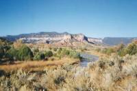
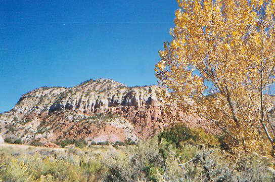
It was a good morning hike, about ten miles before lunch. It started out bitterly cold, but warmed up nicely as we walked along the Chama River for a few miles, then up into colorful Ojitos Canyon. We needed water, since the Chama is too muddy to filter, but we missed the first spring completely and almost missed the second one, a green watering trough hidden in tall grass and sage. Despite the garden growing in the water (lots of algae), the water was clear, though we still filtered it since it gets used by cows and wildlife as well as thirsty hikers. The cliffs were beautiful as we crossed the valley in sage desert, then the vegetation changed as we climbed from sage to piñon pine and juniper, then up to ponderosa pine. As the valley narrowed, we ended up jumping the small Ojitos Stream a dozen or more times. At first the climb was very gentle, but the last two miles were steeper, a steady switchbacking back and forth and round about a very serpentine trail. Lunch was at the top, in a patch of warm sunshine. It is so nice to be warm again.

LATER: For the first time since Wyoming, I hiked in shorts and a t-shirt. It felt good. Now the sun is down and Im bundled up again. The afternoon was easy up and down on dirt roads. The back side of the Mesa Alta was as spectacular as the front side: pink, yellow, purple and white banded cliffs. We had a water scare at the end of the day, when the aqueduct in Ojo Canyon that JW wrote about turned out to be the tunnel under the road, not an irrigation ditch. We couldnt see any water below, as there was only a six inch wide stream hidden deep in the brush. The same thing happened earlier. The stream was dry where we expected to find water, but upstream there was a narrow ribbon of water, just when we had given up hope of finding any. We were very happy to see it, both times. There were some houses at the road near Ojo Canyon, but we were hesitant about asking for water. If the aqueduct had been dry, though, we would have had to ask for help. Knowing that the trail is so controversial in New Mexico makes me a bit wary of approaching strangers for any reason. What if we run into one of the locals who opposes the trail? I know, we could end up convincing them that hikers arent that bad. Or they could take one look at us and decide to head for the shotgun. I wont risk it unless were desperate.
Jim: Last night we camped at a FS river access area - it even had an outhouse. Its also a no-camping area, but it was nearly dark when we got there, so thats where we stayed. Once more we walked until dark before camping. As I said, we have a talent for this.
Sunday, October 24 22 miles to Los Pinos Trailhead (Elev gain/loss: +3430/-2820)
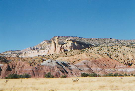
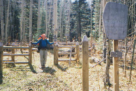
A peaceful morning, wandering on jeep roads in the woods. We saw a few trucks with locals out cutting firewood and one man on foot who tried to hide in the woods when he saw us coming. Were about to enter San Pedro Parks, a high country wilderness area. We had an occasional view of the colorful cliffs and red hills below us as we climbed to the trailhead. We saw several cows and a dozen hound dogs tied up next to a couple of trailers at one campsite. Yesterday, we surprised a grey mare and her white foal trotting freely down a jeep road. I dont know if they were wild or runaways.
This has been a really good section for us, with a lot of variety and some beautiful country, and mostly easy walking. The Ojitos Trail was even well marked with CDT posts, the first weve seen in a LONG time. The only problem has been hunger. This is the longest stretch between towns weve had in a long time - 8 days - and were back to being constantly hungry, even waking up in the night hungry, or waking in the morning after dreams of AYCE salad bars. We eat often and a lot, but it just doesnt stick. Its all like Chinese food, and an hour later, were hungry again.
But generally, weve had great weather, scenery, and walking. Weve been able to make good miles, despite having to stop so early and despite our usual late starts. We break often (have to eat, to keep our energy up) and generally we take our time, yet the miles keep rolling by.
LATER: We ended up practically running down the mountain at the end of the day: 3.5 miles with a 2000' drop in only an hour. We had planned to camp somewhere along the stream on the way down, but there was no place even remotely flat to stop. We had wanted to go, just a bit further. Instead were camped at the trailhead on the far side of the San Pedro Parks. It was a nice area, though smaller and not as unique as I expected. It resembled countless high country areas in Colorado and Montana, with big open grassy meadows surrounded by spruce and fir forest. Pretty, certainly, but not unusual. Though I imagine the northbound hikers welcome it as a change from the sage and grasslands. We met four hunters on horseback, but no wildlife. They said there are quite a few people out in the wilderness (its prime elk habitat) but we didnt see them.
Jim: Another day of hiking until dark. Pretty country, but its also cold. We went through San Pedro Parks and never saw a single elk. That disappointed the hunters that we met. In fact, Im not sure they believed us. Interesting reaction, though - when we first met them, we were beneath notice, worthy only of contempt. But then they found out what we were doing - and the attitude changed. Cant say they liked us, but there was a lot more respect. The final run to last nights campsite was just about that - we were hitting 4-5 miles per hour going down that arroyo.
Monday, October 25 - 8 miles to Cuba (Elev gain/loss: +3700/-1560)
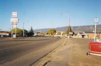
Despite a soft bed in the oak leaves and pine needles, we slept little last night and were ready for sun-up and our walk to town. It was very easy walking downhill on dirt roads, past ranches and houses to the highway that is the main street of town. Its another spread-out town, with a motel, cafe and laundromat on each end of town. The post office is on the far end, so thats where were staying. Its a town with a lot of poor people, I think. Lots of men hanging out on the street. A couple tried to hit us up for money, which is amazing considering how grubby we are. Lunch and a shower helped make me feel human again, followed by ice cream and laundry.
Im not looking forward to the next stretch, which has long waterless roadwalks with bushwhacks to the infrequent springs. Water worries are hard. You can do without anything else, but lack of water affects energy, health etc. It determines route, campsites and mileage. Its heavy to carry, so we try to arrange not to carry it too far. Most of the time we just carry two quarts apiece. For this next stretch, it will be three quarts, plus extra for the really dry stretches. Fortunately, it is cool, so desert heat isnt a part of the equation. This is also the last stretch for which we have detailed directions. Beyond that, were on our own, more or less. Jim Wolfs guidebook gets quite vague south of Grants. We have general descriptions of a couple of recommended routes, but no clear guide for water, mileage, etc. That will be interesting.
Now that we are really into New Mexico, Im starting to believe we will actually finish the trail this year. There are still a lot of miles to go, but with the warmer weather, I think we can make it before winter closes in. In Montana, Mexico seemed impossibly far away. In Colorado, winter menaced us, raising the possibility of an incomplete hike if we decided to jump south, leaving the snowy high country. But now were back to moving slowly but steadily southward, section by section, week by week. I worry a little that weeks of sage and drought will affect my enthusiasm, but I also know there will be interesting places, with some nice walking, lots of sunsets, encounters with people and wildlife, to liven the journey. In six weeks, anything can happen. So I dont worry too much. I havent been bored yet. Why would I start now?
Tuesday, October 26 - rest day in Cuba
We tried to leave town, but were so tired after another sleepless night we just couldnt do it. So we went to the library to check our e-mail, checked out every grocery in town, (numerous, but limited in stock), ate lunch at a nice Mexican restaurant, found some used books at a general store, and napped and read all afternoon. Jeannie, the motel manager, invited all the hotel guests for a free dinner, buffet style. No one bothered to stay and chat except Jim and me. While we enjoyed lasagna, sweet and sour pork, tempura, fried rice, and peach cobbler, a couple of guests came in, filled their plates and left. Odd. Im not sure whether she expected our behavior or theirs, but it seemed rude to respond to her kindness by just grabbing food and running. The motel managers along the CDT have been some of the best trail angels Ive ever met. Its surprising when you consider how many strangers they meet every day, but several of them have really gone out of their way to help us. It was a pleasant surprise. We do appreciate the time and effort (and sometimes money, in the form of reduced rates) theyve been willing to give. We didnt expect it out here.
Home | Links| Trail Journals |
The Thruhiking Papers | Bun-bunMontana | Wyoming | Colorado | New Mexico
Created: Fri, 16 Jan 2004
Revised: 30 Sept 2016Copyright © 1999-2017 Spirit Eagle