|
 |
 |
 |
 |
|
|
|
|
|
|
Thursday, July 1 - 17 miles to Upper Twin Lakes
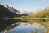
Were camped next to a beautiful lake under the Divide. There is snow above us, but so far none on the trail. The day was a good one, despite the roadwalk. We walked through Anaconda then out along the highway for about 10 miles. There was a wide shoulder and pretty views, so it wasnt too bad, though road walking is harder on the feet than trail. We met another trail angel. A woman driving down the highway stopped to talk to us a few minutes, asking about our hike. She knew we were hiking the CDT, and was full of praise. A while later she returned, handed out some trail snacks she makes for hiking, offered to put us up at her house up the road, and apologized that she couldnt do more for us because she had an appointment. She was very nice. We turned down her offer of a place to stay as it was too soon in the day, but we really appreciated her kindness.
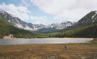
Eventually we turned off the paved road onto a logging road. The loggers are very busy around here. We saw their handiwork and ran into a couple of trucks. We asked one if we were on the right road since there was no indication that the road we were on was actually the one leading to the trail, and there are a lot of logging roads in the hills here. Most of the recent ones-- the ones still in use--arent on the maps. Fortunately, there wasnt too much confusion this time. After a while we ran into horse tracks and followed them, on the assumption that if they were out for a leisurely ride, they would head for one of the lakes. Sure enough, we passed their campsite at Lower Twin Lake. The day was typical Montana weather: sunshine and showers. We kept our rain jackets on most of the day, though it never rained for very long. We laugh at the fact that the sun can be shining even as it rains, and a lot of dour black clouds zip by without releasing a drop. We did some good miles, despite a late start. Were all feeling slow, after three days of almost no hiking, plus heavy packs with six days of food. Its been a while since we carried that much.
Dave got some bad news from home that may affect his decision to hike, though in what direction, Im not sure. We can do little to help, but listen. He told us before that he wasnt sure he really had the fire in the belly - the urgent NEED to finish the hike that we have. This will undoubtedly affect that.
Jim: Its good to be out of town again. Were headed into the Anaconda-Pintlars. Ive been anticipating this for a long time. There was a lot of road-walking today, but once we got off the paved road it wasnt bad just had the potential to be confusing. We passed a horse camp, then saw the horse party across the lake when we camped, but they managed to bypass us so we never saw them again.
Friday, July 2 - 17 miles
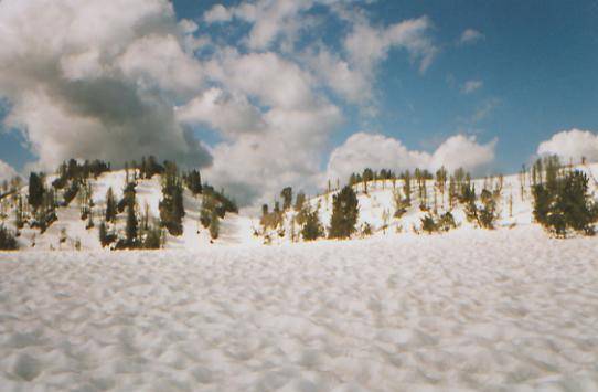
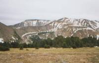
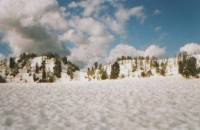
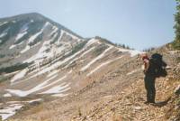
We woke to a heavy frost on everything and ice on some of the wet spots on the trail. The sun began shining and we had a warm climb toward Storm Lake. We never did see the lake though, since we bushwhacked up to the trail over the pass instead of walking all the way around the lake to the trail junction. We began to run into snow at about 8500'. We lost the trail a couple of times, but most of the switchbacks up to the pass were clear until the last half mile. That was slow and steep. On the other side of the pass we had another half mile climb with some really nasty, steep snow chutes. Dave almost fell into a moat around a big boulder. Only his pack catching on the rim saved him from a long drop into the space between the rock and the melted out snow. As soon as we reached Goat Flat, an open alpine area, we collapsed. The views are beautiful, but the snow makes the trail invisible.
We met a father and son walking up the trail. They sped up to the pass, but were stopped by the snow chutes. They had hoped to fish in upper Seymour Lake, but sneakers dont work all that well in snow, so they turned back. They watched us as we traversed the cirque though, making sure we were all right, I think.
Were finally officially in the Anaconda-Pintlar Wilderness. So far it looks pretty wild. Up here at 9200' there are only a few stunted trees on the leeward side of the hills. We can see about five ridges and a lot of grey clouds. It is utterly silent.
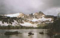
LATER: It never did rain, though the sky stayed grey and gloomy all day. One of the reasons we stopped for the night was a desire to set up before the rains started. The other was that we were climbing toward a pass and didnt want to get too high and run out of snow-free tent sites. We had snow underfoot off and on all afternoon. Nothing steep or scary, just patches on the trail. As we were climbing up to Rainbow Saddle, snow covered the lower switchbacks so we just climbed straight up to the ridge. I was very happy to see that the upper switchbacks and the descent on the other side were snow free. There was a lovely view from the top, but we really had to work for it! The other side was an easy contour around Queener Basin, a big glacial cirque. There were several streams and talus slopes, larch groves and a bear track, and very green slopes. Earlier we had passed a couple of small lakes, Page and Flower. They were nice, but last nights campsite was much nicer. We are all tired and cold. The early snow wiped us out for the rest of the day. We had to work hard to make good snow steps that we could negotiate safely. Anyhow, the good news is there is mostly clear trail below 8500'; we are back on the CDT (the end of the Anaconda Cut-off was Goat Flat); and we wont be likely to run into many people, even though it is a holiday weekend. Few people are insane enough to do some of the things we do. Most are more sensible. They turn around instead of climbing straight up a snow-covered ridge. Not us.
Jim: Today was the most dangerous snow work that weve run into yet several snow chutes, the worst less than 100' across, but an icy 70 degree slope with a huge boulder toward the far side - complete with a moat. Dave fell in but managed to get himself out. This is something I hope we dont run into again. Even Dave said he wouldnt do it again.
Saturday, July 3 - 16 miles to Johnson Lake
We had lunch by beautiful Warren Lake. It is freezing, but the sun comes out occasionally. The ridge behind the lake is jagged and dramatic. Very pretty. We had one pass this morning, which we ended up bushwhacking again since the trail was covered with snow. Then there was a long easy descent to West LaMarche Creek, which we crossed on a log, then a steep snowy climb to the lake. The afternoon will have even more climbs to two more passes and a couple of saddles. We criss-cross the Divide in this section, back and forth. It makes for nice views but hard hiking. We climbed over 5000' during yesterdays hike. Today may be worse.
LATER: We ended up at Johnson Lake tonight, three miles short of our goal. The snow and the climbs got to us. Jim and I were exhausted and just couldnt face another snowy 1000' climb to another pass at the end of the day. The trail is covered with snow even down by the lake. We have finally caught up with the 4th of July hordes. We met a couple of backpackers just after lunch, which was cut short because we were being snailed upon (snow + hail = snail.) Then at the end of the day we ran into a couple of horsemen camping by the lake. Were camped too close to them, but there are others nearby and the camping is limited because of all the snow. Were quiet neighbors, so I hope theyll excuse our rudeness in camping so close.
The walking wasnt that bad, despite the snow, but we did three major climbs and a few little ones. Since we end up bushwhacking each pass, which is exhausting, the snow plus almost 6000' elevation gain was just too much. The views from the passes were beautiful. We could see south to the snowy Bitterroot Range and the closer peaks of the Divide. We passed three lakes, plus one half-frozen one that we could only see from above. Warren Lake was the prettiest, though Johnson Lake has blue skies and sunshine, which gives it a certain allure. The view from Rainbow Pass was one of the better ones, with range after range visible from the ridge.
Jim: Once more weve been checked out by a ranger - he showed up about a half hour after we got to camp. We stopped early - so it was a good time to dry out some clothes and the tent. We talked to the horsemen for a little bit on the way in - 2 of them, father and son. The son wants to ride his horse along the Divide. Good luck - I dont think the horse could get some of the places weve been - certainly not in the snow. Maybe another year. There were a whole mess of people camped here tonight we thought about moving on, but the next thing on the agenda is a climb over another snowy pass. And were just not up for that right now.
Sunday, July 4 - 16 miles
We woke to clear skies and freezing temperatures. The climb to Pintlar Pass wasnt bad, though the last part was straight up. We could see slide marks from other hikers who skied down the slope. From there we followed Jim Wolfs suggested shortcut to frozen Oreamnos Lake. As usual with such things, it took longer than the trail would have taken. There was easy trail to the lake, then a very steep and long climb up a snow wall from Oreamnos Lake, then a very very steep descent, mostly on dry ground, to frozen Sawed Cabin Lake, then another snow wall up to the trail on the other side. We did a lot of hiking in and on sun cups. They make it easy to climb, but hard to traverse. I am getting better on the snow, but straight up and down hiking is still very slow. The trail, when we rejoined it, was buried, but it was pretty obvious which way we needed to go. For a while we had clear trail, views to the south, and easy walking. Happiness is! It began to snow but that didnt last, so we found a flat foggy spot to eat lunch.
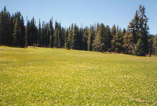
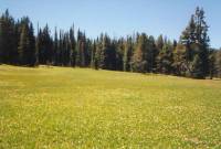
More snow drove us from our lunch spot, but later the day cleared up. It just got colder. The afternoon was much better than the morning as we followed on or near the Divide. The woods were light and open and we had occasional views off the ridge to the Big Hole Valley to the east, snow-covered mountains to the far south and green wooded hills to the west and near south. The Divide isnt as dramatic as it is farther north, but the walking was a lot easier and the views were rewarding. We met only two people today, women backpackers heading the other direction. Dave pointed out a squirrel carrying a baby squirrel in its mouth. There were some pretty meadows but water was scarce. We had a water scare at the end of the day. We were heading toward a small creek, hoping to camp nearby. What we found was a nasty stagnant mudhole at the bottom of a dip. Even after filtering, the water was brown and tasted funny. Dave went ahead and found another, better creek. Its not much better, but at least its clear. The next water was three more miles up the trail, which was too much at the end of a long day. We were all tired and hurting. The morning bushwhack took a lot out of us.
Jim: A long day - doesnt necessarily mean a lot of miles. Sometimes its a lot of elevation - or a lot of snow and vertical climbs and descents. The route through Oreamnos Lake was beautiful, but not easy the descent to the lake was a steep snow chute with a ribbon of rock and trees along the side. We crawled down that ribbon.
Some time back we added another type of pain to the litany Ive got a problem with an ankle now. It seems to be OK for a while, then the gremlins start up the chainsaw and try to cut the foot off right at the top of the boot.
Monday, July 5 - 19 miles
This morning was full of views as we followed the Divide. We could see in all directions from various viewpoints. It was clear and very cold when we started. We walked on rime ice until about 11:00 a.m., and most of the puddles were frozen, but it warmed up nicely midday. Lunch was on a sunny hillside, where we enjoyed the sight of snowy mountains to the south. A lot of the forest has been burned, but it has been a while as the new trees are about 15' high. The area has little snow cover, though there was some early in the day. We saw a couple of elk--one with a nice rack-- and a couple of grouse. The trail obviously doesnt get much use, as there is little tread, but there are cairns to show the way. We left the Anaconda-Pintlar Wilderness, but in many ways this is more wild.
Jim is still in constant pain - tendonitis in one ankle and a pinched sciatic nerve. While I am happy, enjoying views and sunshine, every step is a struggle for him. We took it slowly, stopping often to enjoy the views and to rest his foot and leg. Mostly I think we just wanted to enjoy the sunshine. For the first time in two or more weeks Im wearing a t-shirt. We decided to cook dinner for lunch since there wouldnt be any water at the end of the day. It made a change. The afternoon and evening were easy, but slow, mostly gentle ups and downs in the woods. We went slowly because of Jims leg and didnt stop for the day until 8:00. I hate seeing him in so much pain. Hes stubborn though and wouldnt stop until we reached our destination, a pass on the Divide.
We got semi-lost a couple of times. First the trail hit some dirt roads and the description didnt match reality at all. There were CDT blazes along one of the roads, so we followed it, but nothing else matched. Then we were supposed to cut off the road at a meadow with a stream. We found a meadow and a stream, only it was the wrong meadow. Evidently a lot of people make that mistake as there was a good path into the wood for about 100 yards. The right meadow was 1/4 mile away. Then we crossed a huge clear-cut. We had just met some backpackers who mentioned heading northeast through the clear-cut, so we headed southwest, looking for a road heading south. Wrong move. The trail went straight across. We gave them all sorts of advice about the trail through the Anaconda-Pintlar. We probably scared them a bit, if they took us seriously. I wouldnt want to go down some of the passes we went up, especially without ice axes, and they had a pretty ambitious schedule.
Jim: This isnt a day I can talk about it was beautiful, but there was too much pain for me to really appreciate it.
Tuesday, July 6 - 11 miles to Wisdom
I hate hitchhiking! Standing out in the sun, feeding the mosquitos, watching forlornly as one tiny car after another passes by. All the pickups are heading in the other direction. Grrr. I dont have patience for this!
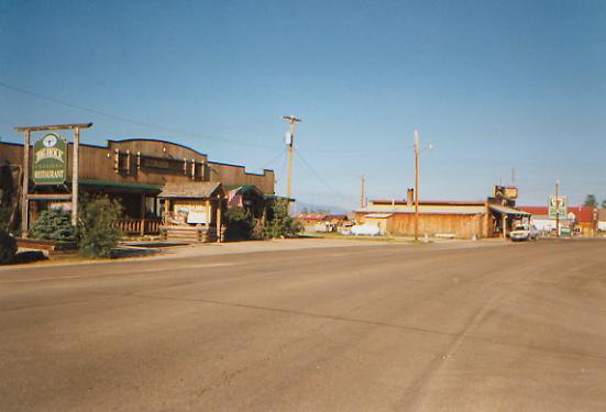
The morning was nice, just gentle walking through the woods then along a woods road. We lost the trail, but the road we were on was headed in the right direction, so we continued to follow it. We met some people on an ATV, spraying invasive weeds, who confirmed that we were headed toward the pass. Trouble was, it was the wrong pass - Lost Trail Pass instead of Chief Joseph Pass one mile up the highway. No problem, it was an easy walk up the hill, then a very long wait for a ride into town. It took about two hours until a ranch couple, pulling a horse trailer, picked us up. We rode in the back of the truck with their very friendly dogs to the small town of Wisdom. It has a small grocery, two motels, two restaurants, a bar, a laundromat and a gas station. The motel is more expensive than expected, as was lunch. Like much of Montana, the town depends on the tourist trade, which has a short season, so prices are correspondingly high. We were supposed to meet Willis Whoa Jarvis, a northbound CDT hiker, here in town but he got tired of waiting for us between the heat and mosquitos and left town this morning. Im sorry, as I was looking forward to meeting him. Weve followed his adventures via the Internet since he left his home in Arizona.
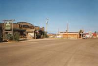
Im not sure how long well stay here. Until Jims ankle gets better, there is no point in continuing. Every step is agony. Thats not good for him and it isnt good for Dave and me since we have to witness his pain without being able to help. A group can only move as fast as its slowest member. Sometimes thats me, but right now were trying to do too many miles for Jims sore ankle. If he cant enjoy the trail, then why are we here? I worry that if he doesnt get better soon well have to leave the trail and Im not ready for that. But I hate watching him suffer. On the other hand, he says hes not willing to stay here in Wisdom. Theres not much here but heat and mosquitos. The motel has no phone and the TV selection is pretty sparse. The town is tiny and closes up at 6:00. There are no books, magazines or newspapers. The motel owner let us use his computer to check e-mail and send a message to Kahley, but for phone calls we have to go to the gas station and brave the ferocious mosquitos. However, the mountains around are beautiful, with snowy peaks in the far distance. The Big Hole is a broad valley with many ranches and a historic battlefield, but the town isnt really good for a long stay.
Were in the middle of a heat wave: two days of summer, at long last. Here in the valley, the heat is intense. Up in the mountains it is finally not freezing. Maybe the snow will melt at last.
Jim: We were supposed to come in here (Wisdom) to resupply and to rest my ankle until its better. Aint gonna happen. One turn around the town told us that this wasnt a place to spend a lot of time so well stay for a day or so and then move on. The walk this morning was a nightmare there were times when I had to stop every 100 yards. I even tried walking in Tevas even that didnt help. As I told Dave Ill keep going even if I have to do 5 mile days. Im not ready to go home in spite of what my body is telling me. On the other hand, we still did 11 miles before noon.
Wednesday, July 7 -- Wisdom - 0 miles
We took the day off to do laundry and rest Jims foot. Lots of ice and a hot bath have helped a little, but well see tomorrow how it feels. It would be better to take more time off, but thats expensive and theres not much to do here but eat and watch the locals. This is working ranch country, so there are lots of real cowboys. We ate pizza at the bar and got a glimpse of the local townspeople. The tourists eat at the nice restaurant (wonderful cinnamon rolls!), the locals at Fettys or the bar. Actually, Fettys is also a bar, complete with Keno machines, pool table and poker table - occupied at lunchtime. Weve eaten a lot, too much probably, but this next stretch will be a long one and Leadore, our next stop, is even smaller than Wisdom. How soon we get there will depend on Jims leg. We could get a bit hungry if we have to go really slowly.
Dave is going on ahead. Hes ready to stretch himself. He plans to do 25-mile days now that the snow is mostly gone. Thats hard walking. We will miss him. I couldnt do this trail alone. I know many people who have, including one woman, but it is too difficult and isolated. Dave is pretty outgoing, but meeting only occasional passers-by just isnt enough human contact for me. Casual conversation with strangers can be interesting, but it isnt the same as the companionship of friends.
Thursday, July 8 - 11.5 miles to Nez Perce Camp
We were able to get a ride out of town with one of the locals in return for a little cash for gas and dog food. Fair deal. It looked like a long wait otherwise since the road isnt very busy. We started hiking around 9:30, walking together up the dirt road for a while before we reluctantly said our goodbyes. It was hard to watch Dave head up the road alone. Five weeks of 24- hour a day togetherness builds bonds. We always knew it was coming eventually, but the actual parting was hard.
The day is beautiful, sunny and cool. We are following a jeep road along the Divide, criss-crossing the Montana-Idaho border. The area is covered with lodgepole pines, but there are occasional views on the Idaho side of green hills and snowy mountains. Well leave the road soon, but in the meantime, its easy walking. Thats good since were slow. Jim started out well, but within a couple of miles we were back to a slow mosey. Thats all right; its a good day for a leisurely stroll in the woods.
Later: Nez Perce Camp isnt much better than it was when the McVeighs were here 10 years ago - a little less trash, a lot more horse turds. Still, its a sunny campsite with water nearby, the first water all day. The afternoon started out badly - we missed the turn off the road and walked an extra half mile or so to Anderson Mountain, site of a former fire tower. Too bad its gone, the views were nice. There was no sign at the turn off; it was just another jeep track leading off the main road. There were a lot of those, mostly leading to campsites or logging areas. We never saw a CDT marker all day, much less at the junctions. Oh well, we didnt lose too much time, since the main jeep road ends at Anderson Mountain. We were a bit worried at first that the trail we were on wasnt the right one, especially after hearing about a CDT hiker a few years ago who got turned around, ran out of food and had to be rescued by some locals out on a day hike. Fortunately the trail followed a ridge heading east - the Continental Divide, in fact. There were nice views along the trail, though it was a hazy day so there was no point in taking photos. The mountains looked more like the Blue Ridge than the Rockies. It was a good afternoon. Slow, as the trail gets steep and rocky in places and we lost the tread in rocky meadows from time to time, but we made it. Jims foot is hurting and my boots have shrunk suddenly, so the short day was good for both of us.
Friday, July 9 - 14 miles to South Fork of Sheep Creek
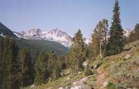
Another sunny, hazy day, traveling along the crest with views west and south. There were lots of green flowery meadows and steep ups and downs. We leave the Divide for a bit this afternoon; its too rugged around Sheep Mountain and Pyramid Peak. Looking at the snow atop them, Im just as glad. It has been good walking this morning. We slept well last night. I had intended to go watch the sunset from a hill up a side trail near the campsite, but we were asleep long before the sun set. We went into the tent to escape the mosquitos, and reading Lord of the Rings put us both to sleep. I must have a soporific voice. Ive enjoyed reading it out loud though.
This is beautiful country. It reminds me of Virginia, with green rolling hills and meadows, covered with spruce and lodgepole instead of hemlocks. We saw a couple of deer this morning, otherwise weve had it to ourselves. It is pretty dry country. The flowers are mostly lupine and paintbrush, though there are several others too. The rocks shine silver and gold. What is the silver version of pyrite? Fools silver?

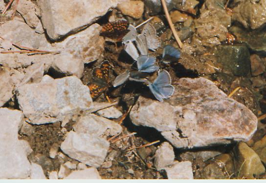
The afternoon was harder than the morning. The trail was rough, overgrown, with lots of blowdowns and very steep climbs. We took a couple of long breaks, once to soak our feet in an icy stream and again at the top of a nasty climb. Summer is here, for the moment. There are lots of bugs and heat, but also swarms of butterflies (blues, a tiny black one with white spots, and three different brown, black and gold ones.) Near a stream, dozens flew up at every step. There were lots of wildflowers too: dark pink roses, trillium, columbine, and many others. The beargrass is starting to bloom. I like its tall white spikes. I was able to wash up tonight, a real rare treat. The water was freezing, but it felt so good to wash the sweat off. Usually the air has been too cold, or the water is snowmelt, so I dont dare. It was wonderful.
Saturday, July 10 - 13 miles to Lower Slag-A-Melt Lake
It was a beautiful morning, though we got off to a false start. We were told, in Dividends, that there was a shortcut at 8.7. Sure enough, there was a trail at about 8.7 heading left. We followed the blazes for about 1/3 mile. They disappeared at a campsite. We wandered around looking for any sign of the trail, then decided to backtrack. Another 1/4 mile there was a split in the trail with an arrow pointing left. Assuming that this was the shortcut, we took it. Good enough. It rejoined the main trail a mile later. Then another trail, again blazed, took off to the left. This time we stayed on the main trail. It was the right choice, though it was about three more miles before we saw a CDT marker. The trail was excellent, the signage non-existent. It was a climbing morning 2000' in the first five miles. There was snow up high, enough that we got out our ice axes. The ridges are steep and rocky, a portrait in gray and white. We crossed the Divide and decided on an early lunch, enjoying a view of Squaw Mountain. I really like this area. It is wild and scenic with lots of views. In many places the trail is a cruising trail, a delight to walk on. In others you pay with killer climbs and lots of blowdowns. Its an interesting mix of beauty and difficulty.
We ended the day utterly whipped after only 13 miles. The 5000' total climbs may have had something to do with it, including 1000' to end the day. It was hot and dry. I ended up putting snow under my hat and in my bra to cool off. We had intermittent snow patches, nothing scary, just time consuming. The Slag-A-Melt Lakes are pretty--a deep, dark blue with jumping fish. If it were warmer, Id go swimming, but the snow just above is a reminder of how cold the water is. Jims foot is a little better, but still painful. Walking in the snow didnt help any.
Jim: This has been a beautiful section but difficult. My ankle hasnt helped at all, but the major difficulty has been the up-to-the-pass then down-again nature of the trail crossing 2 or 3 passes each day. And each pass is snow-covered. Much of the snow has become rotten, making walking even more difficult.
Sunday, July 11 - 14 miles - to Salmon
Our first few miles were on easy new trail from Slag-A-Melt to Lena Lake. It was easy cruising with occasional views. We smelled smoke from a campfire, but didnt see anyone. The trail to Little Joe Lake was another story. It was much rougher and steeper, but with cairns and orange paint blazes. That was helpful since there is still a fair amount of snow on the trail. We saw some very fresh bear tracks. The area is beautiful, in a desolate sort of way: grey and rocky with sheer cliffs and lots of snow. There are some trees and meadows, but they are overpowered by the immensity of the stone. We had lunch in a little meadow by a stream. There was a derelict cabin beside the water. Who lived up here, and why? It is beautiful, but so isolated.
Monday, July 12 - 0 miles
Early Sunday afternoon, all plans were changed. While climbing up the steep (400' in 0.4 miles) and snowy pass between Little Lake and Rock Island Lakes, I grabbed the wrong rock and started a rock slide. In trying to protect my legs, my hand got crushed: fractured and sliced wide open. Blood sprayed all over me and the rocks and snow. Jim untangled me from the rocks, got me to a flat dry spot on top of the pass, put my finger back together and bandaged it. We looked at a map and saw that the nearest road was about seven miles away, at a campground. Descending through the snow, we prayed for someone to be there who would help us get to a doctor. After four hours of a long steep descent on rocky jeep track, we saw the wondrous sight of a red pickup. The window rolled down and the driver said, you look like you could use some help. We asked where the nearest emergency room was and were told, Butte, or maybe Hamilton, 100-150 miles away. Thats a long way when you have no car and its 6:00 on a Sunday night. Hop in, well take you there.

Mike and Michelle Palmer and their son Zeb were out looking for fishing lakes. Mike is the pastor of the Salmon Valley Baptist Church and an avid outdoorsman. They are very nice people. They drove us to Hamilton, waited while I was cleaned up, x-rayed and stitched, bought us sandwiches at Hardees, and offered to let us stay at their church in Salmon. They are hosting a large group of volunteers who are building a new sanctuary. The group travels around the world building churches - two a year, I think. Kind of a Habitat for churches. A lot of the volunteers are from churches that were built by the group in the past. Do it yourself, then help others do it themselves. They will stay about a month. The local church members prepare meals for the group. Mike figured that two more wouldnt be much trouble, so we were invited to stay a few days until we are ready to go back on the trail. In two days a doctor will look at my finger to see if its infected. If not, we can go back on the trail. Everyone has been very nice. Jim is helping with the construction, clean-up mostly, while I am visiting and resting. We got no sleep last night as my hand was really throbbing. I got word that my mother is in the hospital, so Im glad to be where I can call to see how she is doing.
It feels good, but odd, to be around church people again. It has been a long time. I know that Mike and Michelle were sent in our hour of need - Gods angels or trail angels, is there a difference? We desperately needed help, didnt know which way to turn, and there they came, willing and able to help. Thank you God.
July 12-16 - rest days in Salmon
Home | Links| Trail Journals |
The Thruhiking Papers | Bun-bunMontana | Wyoming | Colorado | New Mexico
Created: Fri, 16 Jan 2004
Revised: 30 Sept 2016Copyright © 1999-2017 Spirit Eagle