|
 |
 |
 |
 |
|
|
|
|
|
|
Thursday, June 24 10 miles to Elizabeth Lake
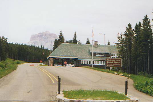
Sitting in the tent, Im listening to a horrendous thunderstorm outside. While the morning was beautiful, we felt our first shower as we ate lunch near the trailhead at the Chief Mountain Customs Station on the Canadian border. It took a long time over an hour and a half to get a ride this morning. A retired couple, heading to Alaska, finally picked us up in their RV. Carita said that seeing me convinced her to pick us up, while Marshall said it was Jims white beard. Besides, theyre hikers and their son hiked the AT. Small world! They sold their house, bought a nice RV and have been traveling for 25 months. They were very nice and interesting people who have made travel and photography part of their lifestyle.
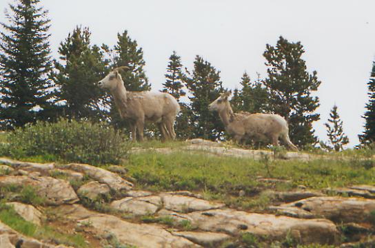
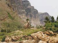
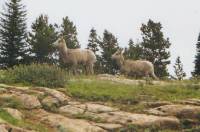
We made a side trip to Many Glacier to look at the lodge, which turned out well since we saw five mountain sheep in the parking lot there and then a young grizzly bear playing Ferdinand, munching on glacier lilies in the woods near the road. We were dropped off at the border about 1:00 p.m., about 5 hours after we started our hitch.
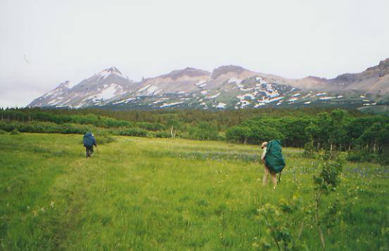
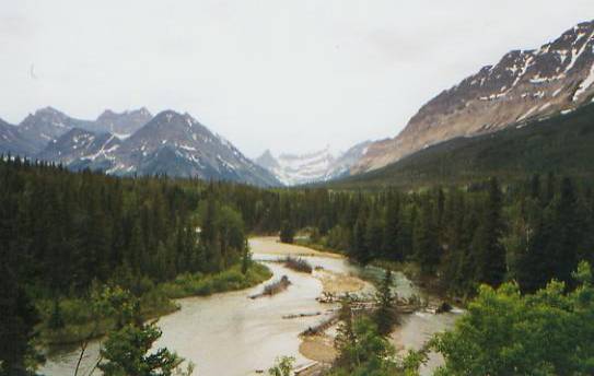
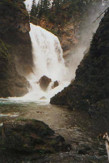
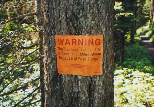
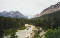
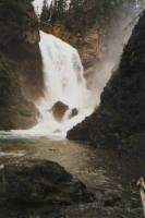
The walk south was pleasant. There are nice views of the mountains thereabouts: the Sentinel, Bear Mountain and the Gable. The colors of the rocks are beautiful, with a lot of red and yellow. The Gable was striped: red, yellow, black, red, yellow red. It looked like a rainbow. There were flowery meadows with several new flowers, including wild roses and geraniums. We were astonished at the number of people we met, going both directions. The good trails and many hikers are such a contrast to last week. We stopped at a beautiful waterfall: Dawn Mist Falls. It was really powerful with a tremendous spray. There is snow and several waterfalls above, but in the valley it was a warm summer day. A horse tried to chase us out of his pasture near the ranger station. It rained again just before we arrived at Elizabeth Lake and while we were fixing dinner. Its the first time on this trip that that has happened. And, of course, in Glacier the cooking sites are far from the tentsites, so I couldnt just pop into my tent and cook from there. Not in grizzly country.

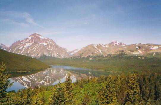
We have a nice campsite near a beautiful lake. We got a large private site away from the others. Theres no lakeside view, but in the rain we cant see much anyway. We talked to several people while we cooked dinner. It was fun to watch the preparations of one couple from California with their multiple courses and bottle of wine. It looked good, especially after three weeks of Liptons! At the outhouse, a spruce grouse or ptarmigan tried to attack me. I fended it off with the fanny pack. I must have been too close to her nest. The ranger, Shane, said they have a problem flying squirrel here who chews on hung food bags, letting the food drop below for the bears. I hope it doesnt come out tonight. It feels good to be on the trail again. The rest did us some good, but we were all ready to leave. This trip through the park feels like a vacation: short days, good trail, a shower midway. Jim is talking about trying to change the schedule, pushing it up by a day, but I think the Park is not very amenable to changes. Besides, if there is snow in the higher country, 19-20 mile days would be really difficult.

Jim: When Marshall and Carita dropped us at the Canadian border, we walked around the Canadian Customs booth and then headed south. We were questioned on the way back by the US Customs personnel - they didnt see us get out of the RV and wondered where we came from. Then we stopped for lunch a couple hundred yards into the woods - and were questioned by a Park ranger who was headed out for a couple days off. She wanted to see our permit. Dont know what she thought we were doing there. Another ranger, Shane, was at the campsite. We had met Shane while we were in East Glacier - he was having lunch at the Two Medicine Grille while we were there. It was a surprise meeting him out here again even though I knew he was a backcountry ranger in the Belly River area.
Friday, June 25 - 10 miles to Poia Lake
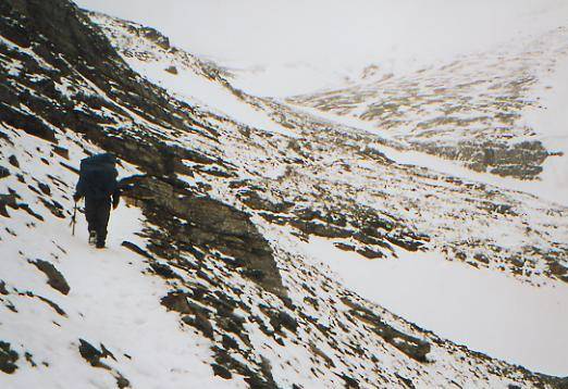
It was a wretched day for hiking. The rain started up again as we were packing up this morning. The lake was choppy and clouds descended to water level. That was really too bad as the ridge beyond the lake is very dramatic. I had hoped for some pictures as we climbed the 2600' to Red Gap Pass. There were intermittent snow patches on the climb, mostly short and easy, though a couple were icy. It was very windy at the Pass and the rain changed to sleet and snow. The rocks were all red or green with an occasional yellow or orange one for contrast. It wasnt a bad climb aside from the weather. Unfortunately, the views were clouded over. On the far side of the pass, we lost the trail in the snow. We followed faint indentations for a while, then realized the tracks probably werent human, so we backtracked to find another set of tracks leading downhill. The snow continued for about a mile. The rain, sleet and wind lasted longer. We reached our designated campsite about 1:30 p.m., thoroughly chilled. We could barely function, especially our hands, which were swollen and useless. We managed to eat some lunch, then decided to set up the tents and climb into the sleeping bags to warm up. There is only one campsite open here; the rest are still covered with 6' of snow. The wind is still fierce. We had to cross the lakes outlet on a bridge and I was afraid the wind was going to push me into the water. We briefly considered moving on to the campground at Many Glacier but we were too close to hypothermia. Besides, we might have arrived to find no room at the campground since our reservations were for this campsite, not that one. After a long day, that would be a real problem. Instead, well rest in our warm bags and read until dinner time. Its too bad fires arent allowed; this is one time a fire would be very welcome.
Jim: We were in camp by lunchtime - partly because there was no reason to stop. It was a completely nasty day with rain, sleet, high winds, and lots of snow that buried the trail. Until we got up this morning Id been thinking about going into Swiftcurrent a day early and rearranging our schedule through Glacier. It would have put us a day ahead. But when we got to the campsite, I didnt even consider going any further - Ginny was too close to hypothermia and Dave and I werent far behind. So we set up camp and spent a quiet afternoon reading, dozing and listening to the wind and rain outside. This IS the rainy season in Montana after all.
Saturday, June 26 - 8.5 miles to Many Glacier campground
We had only a short hike to the campground. The next campsite is 13 miles from here, which would be a long hike in these conditions. We had intermittent sunshine and showers as we were hiking. There was fresh snow on the hills, though none on the trail. It was very nice hiking, with one big climb to start out, then downhill to the road, then two miles along the road to the campground. We had lunch at the Italian restaurant at Swiftcurrent. It was okay, but the portions were small so we went to the camp store and bought ice cream. Ben and Jerrys to the rescue. Weve spread our gear out in the sun to dry. It feels good to just sit in the sun and relax. Yesterday I was the coldest Ive been on this trip, and thats saying a lot. It was pleasant reading in the tent listening to sleet slide down the sides and we slept surprisingly well. There was supposed to be a bear on or near the trail today so we made lots of noise. We saw one small bear track, but no wildlife. Well take a shower and do laundry later, after our stuff has dried out a bit. We dont dare leave it; that would be sure to bring on the rain again.

Jim: We stopped at the Ranger Station and met some of the same rangers that were here last year. A couple of them remembered us. More good food and were camped in the same campsite we were in last summer. We watched the hillsides for bears after dinner we saw a couple, but were having trouble taking them seriously because they were just little dark blobs on the hillside. We couldnt really even be sure they were grizzlies. We went to the campfire program tonight. The ranger there totally and pointedly ignored us - I think he knew what we were and didnt care for the idea. When we asked about the trail ahead, he just said it was impassible.
Sunday, June 27 - 17 miles to Reynolds Creek
This wasnt one of our better days. It was a challenging one. I knew it would be, both from memories of last year and from the naturalist at the campground who told us the trail was closed by snow three miles up. Worries about today kept me tossing and turning - that and too much caffeine. Town food gets me again!
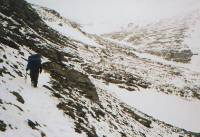
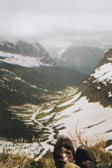
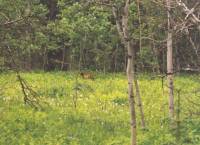
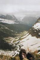
We woke to sunshine and clear skies. As we walked along Swiftcurrent Lake, a couple of early morning walkers pointed out a moose munching moss near the trail. Josephine Lake was pretty as ever. It wasnt until we approached Grinnell Lake that we began to get snow on the trail, but then it was non-stop for the next 10 miles. We climbed about 3500' from there. There were two bad icy knee-deep stream crossings. The first was too fast for me, so we scouted out a better crossing downstream. The second wasnt hard, just cold. We had a lot of climbing in the snow, very exposed though not too steep. As we climbed, it began to rain, then snow. Finally, we topped Piegan Pass, stopped for lunch, and the sun came out. It was beautiful, though Morning Eagle Falls and Grinnell Falls were at half strength because of the snow. We ran into footprints at the top of the pass and discovered snowboard tracks straight down the ridge. Someone is very good and totally insane. We followed their tracks down the mountain, then lost them when we neared the bottom and began to run into dayhiker tracks, going in circles. We ended up at the wrong trailhead, two miles down the road from the trail we wanted. So we walked the road to our trailhead at Jackson Overlook. Another mile or so saw us at the campsite. Unfortunately, it was raining again, so we set up the tent and cooked dinner in the rain. Yech! Then to add the final fillip, a ranger came around to tell us the trail ahead is closed due to bear activity. A bear tore into a couple of hung packs at the campsite by Red Eagle Lake where we were supposed to camp tomorrow. They closed the campsite and the trail past it. We have a choice: walk the highway for 40 miles, do a 21 mile day tomorrow over two snowy passes past Red Eagle Lake, or cancel the rest of the trip through Glacier. We ended up deciding to cancel the rest of our Glacier trip. The roadwalk really didnt appeal weve driven that road and the 21 miles isnt safe, not with the snow in the high country and uncertain weather (not to mention the grizzly we would have to bypass.) Im depressed about it, though I shouldnt be since we hiked through the park last year, just in case we ran into this kind of trouble. A part of me says we should have gone for the 21 miles, but since the ranger didnt think anyone had even climbed Triple Divide yet, it seemed too chancy. Grr! What is really frustrating is that the whole situation could get resolved tomorrow. She said that if its a black bear, theyll remove it, while if its a grizzly theyll close the trail indefinitely. (The once popular trail up Red Eagle Creek has been closed for 50 years!) I dont like breaking the continuity of the thru-hike. Despite our flip-flopping, it was a continuous hike, now therell be a gap. Thats a bad precedent. It makes it too easy later on to decide to hitch down the road instead of walking it. Oh well, we really have no choice. The ranger wanted an immediate decision, and we gave her one. We cant change our minds now.
Jim: Were back in the snow again - Piegan Pass and Morning Eagle Falls look a lot different when its white and icy. It made it somewhat easier that wed been here before and actually knew where the pass is. Its not obvious from the north. We went high up on the ridge on the way up- and I think wed have made better time if wed stayed closer to where the trail actually goes. But thats hindsight again. Once we were over the pass I thought wed be home free with less snow, but it didnt work like that. The trail off the pass and around the cirque was snow free but when we got off the trail around the cirque we were back into it again, with nothing but someones tracks to follow and no assurance that he was going where we were. We got out of there the hard way. I think the amazing part is the number of other people who were up there - one of them a couple miles from the road with no jacket, no pack, not even a water bottle. Idiots abound. I wont comment much on the bear situation. If wed done what I suggested doing (accelerating our schedule and blowing through Many Glacier a day early), wed have been at Red Eagle Lake and the bear would have gotten our food too. Not all of my ideas are good ones.
Monday, June 28 - 1 mile to East Glacier
Getting a ride back to town turned out to be a bigger hassle than expected. We quickly got a ride to St. Marys in the back of a pickup with a hyperkinetic dog, but then couldnt get one from there. So we went to the lodge for breakfast before trying again. Road construction didnt help any. Eventually, we got a ride to Kiowa, the junction for the roads to Browning and East Glacier. Another hour passed. Finally, we got a ride with a lodge employee on his way to work. By then it was 12:15. We had planned to hike the section from East Glacier to Two Medicine, but it was decided, somehow, that we would head south tomorrow instead and just forget the southern half of the park. Jim and I have done it; Dave will come back later and make it up. Its a good place to come back to - especially later in the summer when the weather is better. Were all disappointed at the way things turned out. Glacier was so good to us last year, its hard to have to deal with the cold wet weather, snowy passes and closed trails when we were expecting so much better.
Tuesday, June 29 - Travel Day to Warm Springs
Montana has a lot of pretty country and we have driven through a lot of it today. We caught Amtrak from East Glacier to Shelby, grabbed a quick lunch, then caught the bus south to Butte. We saw a lot of flat open plains cow country and some intriguing hills and valleys with wonderful rock formations. Up north it was very green; farther south the grass is already turning brown and is mixed with sagebrush and lodgepole pines. The sky has been gray and menacing all day, but it never rained. There was a lot of confusion about our plans. The bus was an hour and a half late leaving Shelby and the ticket-master couldnt tell us when the bus was scheduled to reach Warm Springs. I enjoyed the trip, despite the uncertainties. I like seeing the ranches and farms, small towns, rolling hills and buttes, distant mountains and dramatic skies. We saw a rainbow as we left East Glacier, right over the mountains. I had a brief chat with an Englishman bicycling across the country with his wife for seven or eight months. Theyve been traveling the world for 11 years, mostly on a sailboat. Interesting people. I wish wed had more time to talk.
We got lucky when the bus dropped us off in Warm Springs. Dave and I went into the bar to get water since the store was closed. We started a conversation with the bartender, who told us we could camp on the lawn behind the bar. A couple of bicyclists camped there last night and he has held food drops for hikers in the past, so is very friendly toward long distance travelers. He closed the bar at about 8:30 p.m. so we were able to sleep, despite the noise from the nearby freeway. It started to rain soon after we popped into our tents, so we felt very lucky. Instead of walking in the rain, looking for a place to camp, we slept snug and dry.
Im looking forward to starting a new and different section, once we get past the 25 or so mile roadwalk past Anaconda. We have no way of knowing the snow situation in the Anaconda-Pintlars. I hope its not too bad since this is a section Ive really looked forward to visiting. Many people have told us how beautiful the Wilderness Area is. Turning around and heading south, heading toward Mexico at last, feels good too. We met a man on the trail who asked us where we were going. Mexico, we answered. Youre going in the wrong direction, he replied. There are a lot of miles between here and our ultimate destination. I get overwhelmed thinking about it. Only 350 miles done, 2400 to go. Sounds utterly insane, even to me. So I think about the sections, the Anaconda-Pintlers, the Bitterroots, the Centennial Range, Yellowstone, the Wind River Range, etc. Lots of small pieces, each doable in itself, I hope. Together they add up to 2800 miles of very long trail. There is a wonderful freedom to this life, but also a kind of tyranny in the push to keep walking, covering as many miles a day as possible. There is a lot of variety, never really knowing what surprises each day or each section will have in store, and at the same time a kind of monotony: get up, fix breakfast, pack, walk, eat, walk, eat, walk, set up camp, eat and go to bed before sunset. Each day is unique, but also much the same. Except travel and town days, which have their own routines, mostly centered around food and getting clean. Hiker hunger has hit, especially for Jim. He has lost a lot of weight and is constantly ravenous. Im not quite as bad, though I rarely turn down food. Of course, I havent lost as much weight. L.I.N.F. These next few weeks may be harder on Jim since town stops will be fewer and farther apart. It can be hard to carry enough food to keep our energy up. We have one 9-10 day stretch planned between Leadore and Macks Inn. We may break it up, though it would require a difficult hitch to Lima. Well see how it goes.
Wednesday, June 30 - Anaconda - 10 miles
It rained during the night and most of the morning as we hiked toward Anaconda. I saw four small rainbows between the showers. We followed a road past the state hospital and through the desert, arriving in town at about 10:00 am. The roadwalk wasnt bad, though it was busier than expected as we passed the hospital during morning shift change. The hills are pretty and the clouds dramatic. There were streams and lots of sage and cottonwood. Entering Anaconda, the smelter stack (largest in the world) dominates the horizon for miles before you reach town. There are huge piles of mine tailings. The town itself was surprisingly pretty, with old buildings and Victorian houses and pretty residential areas. The town nestles between two lines of hills, spreading for several miles. We stayed at the Marcus Daly Motel, right behind the Post Office. It was a bit expensive, but the owner is very nice. She drove us to the grocery, a mile away, and waited while we did our shopping. We went to the library to check e-mail. There were only a few new messages, but it was still nice to keep in touch. We had several notes in the mail and Blake sent some goodies from California. After laundry, the day was done. We had to shop for this stretch and also for the stretch after Leadore, so we packed and mailed the Leadore box. We need to start making better miles; the food is getting too heavy. Im worried about this next stretch. Well be hiking at 9000' which means more snow, even though its July. Dave was told that the first pass is impassible. Well see.
Jim: The best part about the last couple days has been the food Ive lost some weight this last couple weeks. Not as much as I will later, but its a start. But it does make me appreciate food more. The downside was having to sit still on the train and bus for a lot of hours thats not good for me. Well be headed back into the mountains tomorrow thatll be good.
Home | Links| Trail Journals |
The Thruhiking Papers | Bun-bunMontana | Wyoming | Colorado | New Mexico
Created: Fri, 16 Jan 2004
Revised: 30 Sept 2016Copyright © 1999-2017 Spirit Eagle