|
 |
 |
 |
 |
|
|
|
|
|
|
Monday, September 27 - 16 miles to Lake Ann
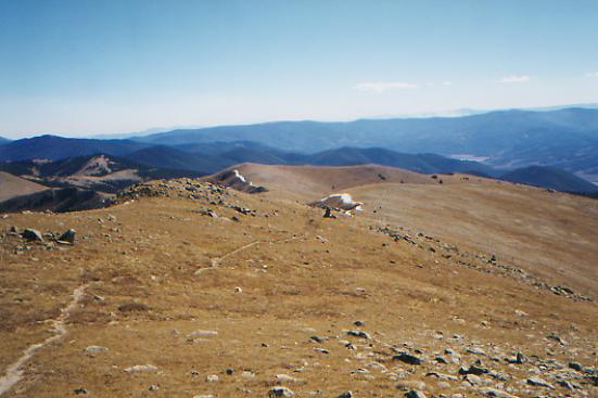
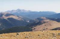
We slept little in our soft feather bed, though it was very comfortable, if not the best idea for a sore back. We woke up early, then discovered that breakfast didnt start until 8:00 a.m., so went back to bed and read for an hour. We made it out of town about 9:15, heading west to the Willis Gulch Trailhead, a shortcut that cuts off an eight mile loop around the lakes. The climb up to Hope Pass was steep, with no views until the end. We climbed 3000' in four miles, then descended 2500' in 2.5 miles. Thats steep. From the top, we had nice views over the lakes and all the way to Leadville. The other side, looking toward the Collegiate Peaks Wilderness Area, was pretty, with a light powdering of snow on the peaks and one brilliant patch of yellow aspen in the valley. The wind was fierce, stealing our breath away. It knocked me about like a prize fighter. Kahley said the forecast for this week is lows in the 20's, highs in the 40's, chance of snow showers. So far weve had intermittent clouds and sun. Sheltered from the wind, if the sun is shining, we are quite comfortable, but I dread climbing up to the next pass. Well hike a few miles in the valley first. The CDT and CT split down at the road. We considered following the Colorado Trail instead of the CDT from here to Monarch Pass; its lower and supposedly easier. But without information on mileage and water, it didnt seem like a good idea. It could be easier, but much longer. Without a guidebook, we wont risk it. Well stick to the Divide. Though, hearing that snow is forecast, we know there is also risk in that choice. Good thing we have lots of food.

LATER: We didnt make it over the pass above Lake Ann after all. It would have been really late by the time we reached water on the other side, so we stopped at 6:00 p.m. just below the lake. It is freezing, literally. The water bag is covered with ice where water spilled on it. My hands ache from the cold. I also have a stomach-ache, but thats another story.
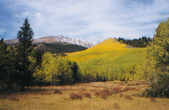
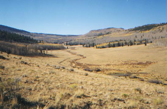
It was a better afternoon than I expected. The climb was easy, mostly on dirt road. The views of the Three Apostles and Granite Mountain were beautiful, as were the other peaks and ridges of the Collegiate Peaks Wilderness. We scared up one elk, who bounced off into the bushes. We passed several old mines, mine sites, cabins, etc. and met a couple who had tried to climb Mt. Huron but were stopped by the high winds. Fortunately, the winds died down around 5:00 p.m. and the clouds went away.
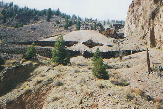
It was kind of eerie wandering past Winfield. The old mining town was deserted, though people still live in some of the cabins in the summer, I think. The hills were grey and brown and yellow. With all the wind this weekend, most of the leaves have fallen already. We even heard a wolf howling in the woods. It seemed so lonely and desolate. Its a little scary.

Jim: One surprise in Twin Lakes was that the small grocery store was open on Sunday and when we went in there, they told us we could have our mail drop without waiting for them to open on Monday morning. Today the climb up to Hope Pass was a bitch-kitty, but we knew it would be. As someone said Thou hast not to like it, just do it! So we did it. Why do I keep on doing this to myself?
Tuesday, September 28 19 miles to Sanford Creek
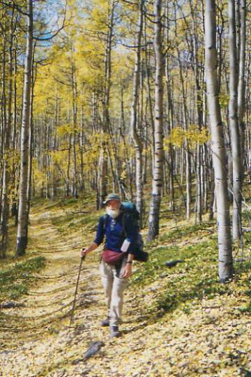
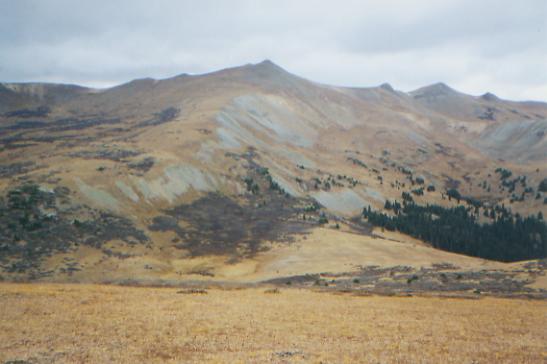
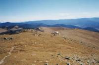
Sitting bundled up in the noonday sun, it is about 34°. In the shade, its much cooler. Puddles are frozen solid and our water bottles have a generous portion of ice in them. I had to crack ice in the stream to get water for breakfast. As we were packing up, it began to snow, lightly but persistently. We climbed two miles up to the pass, which was harder than expected because the snow from last week hadnt melted. It was frozen solid and overlay talus. Oh joy! We had sections of each and sections of both: one step on talus, the next on icy snow. My new boots grip well on snow, which is good, but, oddly enough, I wasnt that scared, though I should have been. It could have been dangerous, and six months ago the trail would have scared me silly. Today I just wanted to get it done. I was cold and yet sweating because of the climb. It was snowing and I was blind because my glasses kept fogging up. So we just kept on climbing. The other side of the pass was snow-free underfoot, but we walked in solid cloud for about half an hour. Then the sun came out and it warmed up a little bit. I really dislike the intense cold, though I rather enjoy being bundled up and cozy while cooking breakfast or eating lunch. The trouble is the runny nose and watery eyes, the wet half-frozen balaclava around my mouth, and constantly adding and subtracting layers as we go up and down.

This section is a connecting section, just little ups and downs over ridges and down to creeks with only glimpses of mountains and a big lake through the trees. The Timberline Trail is used by motorcycles, which is really dumb when you consider that it is only about a foot wide in places with a steep drop-off. What if a horse meets a motorbike? We dont go over the Divide again until tomorrow, I think, which is just as well; Id rather stay below 12,000' when it is so cold. We can hear odd rumblings behind us. Is the mountain falling? It sounds like rock slides.
LATER: The afternoon was much like the morning, with lots of little ups and downs. The trail is used by bikes and motorbikes and is very eroded and rocky with lots of wet spots. We saw some deer today, three for me and three for Jim. We just heard an elk bugle; what a pretty, eerie call! The valley were climbing is a pretty one, though it has lost about 80% of its aspen leaves. What remain are colorful. It is very cold, though the afternoon warmed up a little, at least in the sun. Unfortunately, the sun is touching the ridge opposite us, a golden light but giving no warmth to this side of the valley.
Jim: I suppose the motor-bikes need someplace to go, but its utter idiocy to put horses and bikers on the same trail. But then, they did this in northern Colorado, too. The trail is hard to walk in many places because its so torn up by the motor-biles. Ive thrown several tantrums about it for all the good it does.
Wednesday, September 29 19.7 miles to Hancock
Another beautiful but cold day. It was 19° in the tent this morning (and about 10° colder outside.) Getting packed up was hard, painful for fingers and toes. Everything was frozen, despite being kept in the tent: water, boots, us. Jim and I were both ready to call it quits right then. Two more months of this, no way! But then the sun came out, the trail climbed above treeline, with beautiful views in all directions, and we decided that well keep going, at least for a while longer.
We descended to Mirror Lake (not clear today) and climbed back up to Tincup Pass then down to lunch on the other side. We met a couple from Alabama on motorbikes at the pass. Ive been surprised at how many older people weve met on motorbikes and ATVs. Many used to hike, but dont feel that they can anymore. A lot of the older hunters use motorized transport. Its not just for kids. I still dont like meeting them in the backcountry, but I see that they do have a purpose besides tearing up the wilderness. We havent met any in the real backcountry -- mostly just on the gravel roads and some of the rougher jeep roads, so I havent felt like they were intruding on my space, more like I was sharing theirs. Im surprised at how little I mind. But then, we seldom meet more than one vehicle a day, and rarely that many. Its not like the roadwalk into Rawlins - thank God.
This will be a very strenuous day, with several climbs over 1000' and several miles above treeline. The land is brown and grey. The willows and aspen trees are mostly bare. There are still patches of snow, plus ice wherever there is standing water. Stream crossings become quite interesting when the rocks are covered with ice. Right now it is about 40° I think. Were drying out our gear in the sun and wind. It was snowing inside the tent when we woke up. Our breath and body heat condensed and froze, then fell as snow when we touched the side of the tent. Everything got wet. Were warm enough in our winter sleeping bags, or while walking, but camp time has become onerous as we struggle to cook, set up or pack up in below freezing temperatures. I hope todays warmer weather means it will also be warmer tonight.
LATER: Its still below freezing, but not quite as bad as last night. We saw a lot of frozen puddles and streams this afternoon. There were some pretty vistas as we went up and down above treeline for five miles. The prettiest peak was on the ridge above our campsite near Hancock. The ridge is red, at least in spots. Hancock was an old mining town, but little remains of it. We saw a bushy tailed coyote on the trail ahead of us this afternoon. We ended the day with three miles of easy railroad grade, from the erstwhile Alpine Tunnel. It was nice walking. We needed it. A lot of the trail the past couple of days has been rough rocky eroded jeep track. Not fun!
Jim: We saw a coyote on the trail ahead of us this afternoon. By the coloration I thought it was a mountain lion, but Ginny said that wasnt the case. She can see better than I can anymore and her judgment was confirmed a little later when we heard the coyote pups somewhere off in the bush.
Thursday, September 30 17 ½ miles to Monarch Pass
Lunch is by windy Hunt Lake. It is sunny but cold. We had one nice view at the pass above frozen Hancock Lake, but mostly the trail this morning was a roller coaster on rough jeep tracks or across talus. It should be better this afternoon when we climb back up to the Divide. We will follow that for several miles on the way to Monarch Pass. Right now Im grumpy about all the bad trail. Hunt Lake is a pretty one, surrounded by trees and ridges. The Boss Lake Reservoir, where we had originally planned to stop for lunch, was almost empty, which is odd since Colorado had a lot of rain this year.
LATER: We made it to Monarch Pass and the road to Salida at about 5:30 p.m. The afternoon was very windy as we walked along the Divide. Part of it was scree and talus with patches of snow. I got scared because it was a bad place to be staggering. The views were beautiful, but it was hard to care as the wind buffeted us and we tried to hurry to safety below treeline. We got a ride from the pass fairly quickly with a college student on his way home. He dropped us off at Poncha Springs, about 5 miles from Salida. It took us longer to get a ride to Salida, but finally we did, with someone who thought, as dirty as we were, we must be destitute, and directed us to the thrift store and local mission. When we explained that we werent as poor as we looked, he dropped us off at a nice motel instead.
I feel good that weve come this far, but worried that we still have so far to go. Six days to Lake City, six from there to Pagosa Springs and another five or six to Chama. Thats a lot of time in the high country at this time of year. We may do the Creede cut-off, since we hiked the loop around Creede through the San Juans two years ago. It is beautiful country, which I looked forward to seeing again, but after the cold and snow weve already experienced, I worry about spending more time in remote high mountains. Its a long way out, if we need to bail for some reason. Oh well, the race for the border continues. We need to reach the lower elevations of New Mexico, then we can relax again.
Jim: The ski area at Monarch Pass is confusing and that was just the end of a very exposed and windy section across the open ridge. The pass was already in shadow when we got there, but we spent some time in the shop across the road warming up, drinking a Coke and trying to work ourselves up for a long, cold hitch into Salida. As it turned out, we didnt have to wait too long for the first ride and once we got off the Divide the temperature got back up to something reasonable. Its a long hitch into Salida, but the alternative is a maildrop at Garfield and there are few hiker services other than the Post Office there.
Friday, October 1 - Rest day in Salida
Salida was a very friendly town. We heard lots of cheerful greetings as we passed people on our walk through town. Diane, the motel manager, was kind enough to drive us to the post office, show us where to find the library and grocery, and later drive me to the laundromat. In the morning, she loaned her truck to her housekeepers husband to drive us back to the trail. The only problem with Salida is that it is very spread out. The motels cluster along US 50, with only a few restaurants, while the downtown area is about 1½ miles away, with shops, the PO and more restaurants. Thats close if you have a car, not so close when youre on foot. We wandered around most of Friday. We enjoyed the walk through the residential neighborhood on the way back to the motel. I liked the small neat houses. Dinner was a very good lasagna, delivered to our door, from one of the downtown restaurants. Better than walking three miles there and back.
Saturday, October 2 -17 miles to Windy Peak
When we got back from breakfast this morning, the very nice motel manager, Diane, greeted us with the news that another CDT thruhiker had just checked in. We went over to say hello, and met Jeff Wheatley, another southbounder, whom Jim had met on the AT back in 1991. Small world. Jeff started a month after we did, and passed two thruhiking couples who are about 10 days behind us. We may meet them yet. [NB: one of the couples got off the trail, the other we met in Deming.] We had a good, but brief, chat with Jeff. Diane had set up a ride back to the trail, and the driver was impatient to go, so, reluctantly, we left Jeff and went back to Monarch Pass. I hope he catches up soon, Id like to talk to him again.
It is a very windy day again, constant 20-30 mph winds with gusts. It isnt that cold, except on exposed skin. Im wearing the balaclava again to protect my face. The air is hazy from dust and smoke, and clouds are starting to gather overhead. The hike south of Monarch Pass has been very easy, contouring around Mt. Peck and Mt. Ouray, running along grassy alpine ridges. Nice hiking, though the wind does slow us down. We saw a lot of bicycles start out at the pass. Several turned around after only a couple of miles because the wind was so strong.
Im happy to be out on the trail again, though I dread the cold. Knowing there are thruhikers behind us helps, in an odd way. It doesnt seem quite as crazy to be out here so late in the year when we hear there are others even later. Jeffs AT hike was a winter hike (November to May) so he, at least, should be able to handle this cold.
LATER: The afternoon had more up and down and fewer views than the morning hike, but was still good until the end, when we discovered they had built new trail which bypassed the spring where we intended to camp. We had to backtrack and go wandering to find it. A few snow flurries accompanied the search, but didnt last. We had views of Mt. Antoro, from time to time, and lots of trees.
Jim: Backtracking is not happiness - do it too often and you lose your thruhiking license. That new trail was really nice, but it cost us a couple extra miles. And then we had to find the lost spring that was bypassed by the trail relocation. It was adequate, but barely. But it was the only game in town cause the next spring was 7 miles further - and it was getting dark.
Sunday, October 3 20.6 miles to Razor Creek
An up and down day, in more ways than one. On the positive side, it was sunny and clear and only a little windy - not like yesterday when I was buffeted from all sides. We didnt see anyone at all today. Yesterday we saw eight bikes and four dayhikers. We saw four elk today, including one bull that was quite close, as well as a couple of deer. There were several open grassy meadows, which allowed us the chance to enjoy the sunshine. No big climbs, just lots of little ones. And, finally, we did manage a 20 mile day, despite a late start and lots of breaks.
Of course, that wasnt entirely by choice. Water was scarce since we were high up on the Divide. We ate lunch at 11:00 so we could fill up at the last sure stream. Then the only other sure water was Baldy Lake, ½ mile off trail. We thought about stopping for the day there, but it was still a bit early. The next water, Razor Creek, sounded a bit iffy, but we decided to go for it instead of detouring down to the lake. Fortunately, there was a very small flow where the trail crossed the creek, though it disappeared soon after. We got water and found a campsite downstream in a grove of trees. We were lucky.
The down side of the day was plain bad trail. It was rough, rocky and eroded, heavily used by motorbikes and ATVs. There were occasional views, though there seem to be fires south of here, so it was pretty hazy. Colorado is funny: it has some of the best trail on the CDT and some of the worst. They route a lot of the trail on old jeep roads that are badly eroded, ankle-turning boulder walks. A lot of the foot trail has been over talus and scree. How do people bring horses up there? The CDT marking is almost non-existent, though the Colorado Trail is mostly well marked. Oh well, it is what it is.
Monday, October 4 20.6 miles to Cochetopa Park
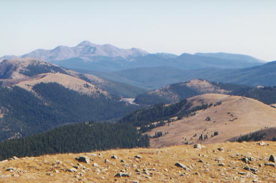
The morning was much like yesterday, a rocky roller coaster. The fire is still burning east of here and the sky is full of smoky haze. It was very cold earlier, but the sun has warmed things up to about 55°, at least out in the open. We had occasional views toward San Luis and Uncompaghre Peaks to the west, and we could barely make out the Sangre de Cristos Range to the east.
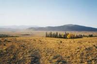
We ate lunch in the sun in the meadow at Colorado 114 beside Lujan Creek. This is where we started our hike through the San Juans two years ago. It looks very different now. The rich green flower-filled meadow of August is now mostly brown and dry. There are still a few golden aspen in the hills behind us. Were below 10,000' for the first time in a while. We saw several little yellow butterflies, just the size and shape of aspen leaves. Good camouflage. The next few miles should be easy as we follow dirt roads through the hills of the Cochetopa. I have good memories of this part of the trail.
LATER: It was a good day. We arrived at our planned campsite beside Los Creek at 4:30 and decided to just cook dinner there and move on. Theres no water for several miles, but we should be able to find a good flat campsite in the next two or three miles. The afternoon was nice and easy. Even the horrendous climb that I remembered so well wasnt nearly as bad as expected. Amazing what 2000 miles of conditioning will do to you. It stayed warm and sunny with just a touch of cool breeze. We saw two deer down by Pine Creek. Yesterday we saw a blue grouse right where the guidebook said, Look for blue grouse around here. It doesnt usually happen that way. My feet are sore, but without the toe cramping that has been bothering me, and since I switched to shorts and long johns, my chaffing has been much better. I dont know why I started to get chaffed by my pants after having no problems for 1000 miles. The more weight I lost, the worse the problem. Odd.
The sunshine the past few days has been a real morale booster. It is beginning to seem that we may get through Colorado without serious snow problems after all. I know, we still have a long way to go, but if we take the Creede cut-off, we can be out of the high country by the middle of the month. I think the present good weather will hold until we get to Creede. From there it is four days to Wolf Creek Pass. South of there, in the South San Juans, there are forest roads we can follow if the snow makes the high country impassible, so we should be all right. So, basically all we really have to worry about is the stretch before Wolf Creek Pass, which is very remote. Well check the forecast in Creede, though that may not help. The forecast for this week said snow flurries on Sunday and Tuesday, but weve had gorgeous weather. Though there was a 90 second flurry on Sunday evening. I guess that counts.
Just as we were packing up to leave Los Creek, a herd of elk, about 18, started down toward the pond for water. When they saw us, one let out a bellow. They milled about uncertainly. When we donned our packs, they ran, raising a cloud of dust. They fled over a small ridge and down the other side into broad grassy Cochetopa Park. I was sorry to chase them away, but we needed to get going, and they werent likely to approach the water while we were sitting there.
We found a grove of trees, very popular with the cows evidently, and were able to clear out a spot and set up just as the sun set. Its amazing how casual weve gotten about sleeping amidst the cow pies.
Jim: Somehow I managed to hurt my ribs today. While we were stopped for a break this morning, I twisted the wrong way and must have pulled a muscle. I felt and heard something snap in there. Today we passed CO Route 114 at about the same time of day that we started there on our trip 2 years ago. In 1997 it took us 6 hours to make the 9 miles to Los Creek. This time it took us about 3 hours. A little difference in conditioning makes a lot of difference in performance. We camped at a cow camp in the middle of almost solid cow pies. While we were clearing a place to put the tent I realized how casually we were kicking the cow pies out of the way and that we werent even complaining. Weve truly been corrupted by the trail.
Tuesday, October 5 - 21 miles to Cochetopa Creek campsite

Another warm and sunny day, very quiet and peaceful. Lunch was on the bench above Cochetopa Creek where we camped two years ago. I think the beaver dam and lodge below are new. The beavers have been very busy along the Cochetopa; there are dams everywhere. It was a good morning, gently meandering through sage, grassland and aspen on dirt roads. We saw three antelopes, a big golden hawk, a flock of bluebirds, and a tiny downy woodpecker. Most of the aspen are bare and grey, but occasional clumps still hold their golden leaves.
We tried to make it to our next campsite from two years ago, but it was getting late and we were weary. The afternoon was an easy climb along Cochetopa Creek with lots of beaver dams, lodges and ponds, but not much else. We saw two men on horseback, a hunter hiding in the brush, and one man sleeping in an enormous canvas tent at the Eddysville Trailhead. Otherwise, it was a quiet day.
We got a bit frustrated earlier at the lack of trail maintenance. Between the horses and the cows, the sidehill is nearly gone in a few places, making a steep slippery slope with little treadway, the kind of balancing act I dislike most. I hate being a tightrope walker! Also, a beaver dam flooded the ford across the creek, leaving us to wallow through the willows in search of a way across. Not fun.
Jim: So much for the vaunted Colorado Trail. Two years ago the trail was in really good shape, now its not. A lot of the sidehill needs heavy maintenance and the crossing of Cochetopa Creek south of the Eddysville Trailhead is a swamp walk through the willows. We missed getting to the campsite we wanted to reach by less than a mile.
Wednesday, October 6 - 16 miles to Creede
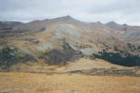
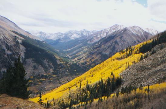
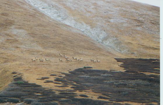
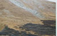
We woke to the gentle slither of snow on the tent. After about an hour it stopped, so we got up and found that none of it had stuck. We ate quickly, packed up and climbed toward San Luis Pass. Actually, there are three passes up there. The first is hardest, as you switchback uphill through the willows. On the other side is a big cirque, which the trail traverses, then a smaller pass, then another large cirque, with a good climb to the third pass. The area is really beautiful, but I wouldnt want to go around those cirques early season when they are covered with snow. In the summer it is a lush green. In October, the hills were orange and grey. The clouds spat snow at us from time to time and it was cold and grey and windy, but still beautiful. Heading up to the first pass, we scared up a herd of 22 elk. They moved away from the trail and watched us for a while, then disappeared over the ridge.
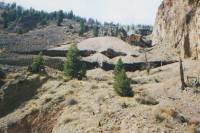
From San Luis Pass, we took a side trail and then jeep roads down to the town of Creede, following Willow Creek. There are lots of mining remnants: cabins, railroad bridges, lots of cribbing and old buildings. It was a busy place at one time. We got to the Post Office, called Lake City where our maildrop was supposed to have been sent, and discovered our package wasnt there. We are a couple of days early, and Kahley trusted Priority Mail to actually get the box there in two days. Oops! At least we didnt have to hitchhike the 50 miles or so from Creede to pick it up. Our original plan had us going to Lake City, but time and weather urged us to cut this stretch short, so we ended up in Creede instead.
Jim: The trail from the Divide down to Creede wasnt what I expected: it was partly trail and partly jeep track and then a gravel tourist road. Wed gone to Creede 2 years ago, but I didnt really remember much about it - probably because I didnt really expect to go there again. It was a better town than I remembered. Even losing the maildrop wasnt that big a deal - the outdoor shop had the maps we needed, theres a decent grocery and there was an ATM so we could get money. But we got here just in time - a lot of the stores have closed for the season and the ones that are still open will close as soon as hunting season is over. When we got here, the snow really got heavy - I think we got out of the high country just in time, too.
Thursday, October 7 - Day off in Creede.
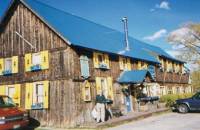
Jim: Were staying at the Blessings Inn. Its one of the few places in town still open. The room is nice, the cat likes us and breakfast is great she makes it to order and actually makes enough to keep me happy.
Home | Links| Trail Journals |
The Thruhiking Papers | Bun-bunMontana | Wyoming | Colorado | New Mexico
Created: Fri, 16 Jan 2004
Revised: 30 Sept 2016Copyright © 1999-2017 Spirit Eagle