|
|
|
 |
 |
 |
 |
|
|
|
|
|
|
|
|
The Pacific Crest Trail
Snoqualamie Pass to Manning Park, B.C.
Friday, September 8: Park Lakes — 15.4 miles (2412.3)
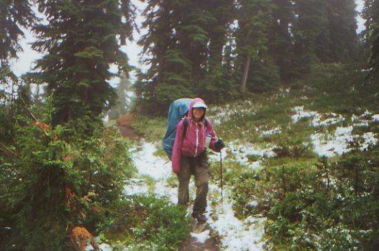
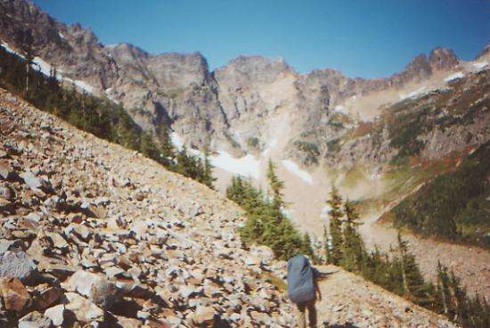
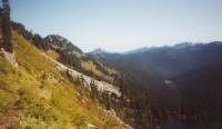
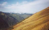
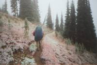
We took Thursday off to do laundry and rest. It was warm and sunny in Cle Elum. Today it was raining, both in town and up on the trail. All day it rained, hailed, sleeted and snowed. By 5:00 we were soaked and frozen, so we stopped early. We had only stopped once all day, for about 10 minutes, so we were tired and hungry. Hypothermia wasn’t far away. I started to shiver as soon as we stopped moving, then couldn’t stop. My fingers didn’t work, making it very hard to unpack and help put up the tent (never easy when it’s raining.) I cried from cold and frustration. It wasn’t a great day. All we could see was that there were steep cliffs all around us. The many talus slopes we crossed told us that too. We did see six lakes. This is the Alpine Lakes Wilderness, and for once the PCT actually goes near them. (I still remember Oregon’s Sky Lakes Wilderness.) The only wildlife we saw were birds, including two grouse that didn’t want to move out of a dry spot they had found on the trail. They were quite upset with us.
We met seven backpackers, including one southbound PCT flip-flopper known as Beaker and one guy camped almost on the trail in a tent. It is frustrating: from the glimpses we got, and the guidebook description, this is beautiful dramatic country. Our best views were about 100 yards, but mostly we could only see about 10 feet ahead. The snow/sleet was interesting, and there were lots of flowers, but it was still disappointing to see so little. Singing helped on the downhills, but it was frustrating slipping and sliding in the mud on wet roots and rocks. There were some powerful thunderclaps nearby as we topped one ridge. Thundersnow!
Saturday, September 9: Spade Creek — 21.9 miles (2434.2)
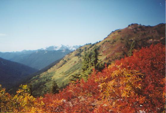
It rained all night, but stopped for a while as we were packing up. We were camped at 4800’ and snow level was 5000’, so we were lucky not to have to deal with frozen gear, just wet. I hate putting on wet clothes in the morning! Today was much like yesterday: off and on showers and drizzle. No sleet or hail though. We got doubly soaked from the bushes. We only walked in snow for a short while up on Escondido Ridge. It snowed about an inch there. We didn’t get much in the way of views, though occasionally we could see across the valley. There were a few gloomy grey lakes and lots of beautiful waterfalls, tumbling from the glaciers above. The prettiest was actually three waterfalls that merged partway down the cliff to become one long 2000’ fall. There was a lot of color from the maples and huckleberries--red, orange and gold. We saw one deer and a couple of backpackers, including Chris, another flip-flopper. He and Beaker were stopped by a forest fire near Belden and decided to jump up to Canada and hike south rather than continue northbound. They have a better chance of finishing the trail this way.
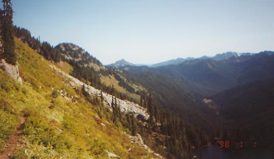
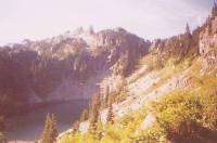
Sunday, September 10: Glacier Lake — 22.8 miles (2457.0)
We woke to heavy rain, which eased as we climbed. It sprinkled off and on all day. The sun came out for about ten minutes late in the afternoon and almost got us to stop early. Our gear is really wet from all the rain this week. There wasn’t much in the way of views, just fog, clouds and drizzle. There were more lakes and waterfalls, some steep cliffs and talus slopes. Cathedral Peak was just a dim outline behind a cloud. We ate lunch hidden in a small grove of trees. There were three big climbs today: 2600’ up to Cathedral Pass, 700’ to Deception Pass and another 1600’ to snowy Pieper Pass. We’re tired. Also cold, wet, sore and chaffed. Not a great day.
Monday, September 11: Skykomish/Stevens Pass—14.6 miles (2471.6)
The sun came out at last. Halleluiah! We can actually see the jagged peaks and ridges all around us. It’s beautiful, especially with the autumn color of the huckleberry bushes. We passed several small lakes and did a lot of steep up and down. At lunch we made a start at drying out our gear. With so much rain, it is impossible to keep the sleeping bags dry. Condensation in our small tents, and even just folding the wet tents in the morning, mean that the inside gets soaked after a while. We spent a pretty miserable night in our soaked sleeping bags. Jim offered to take the wetter side. No wonder I love him! We cuddled to keep warm, but didn’t sleep much. Sly was even wetter in his down bag, but slept like a baby. I hurt in too many places to sleep well, even without the dampness.
We saw only four backpackers this morning, heading south. I imagine the rain kept the weekend crowds down. I don’t blame them. It hasn’t been fun slogging along in the rain day after day. We only had snow and sleet the first day, fortunately, but we walked in a couple of inches of new snow on the north side of Pieper Pass yesterday. Funny, every time we approach a pass I hope the weather will be better on the other side, eternal optimist that I am. Usually it’s worse. The north side of Pieper was solid cloud/fog. The descent, at the end of a long day, across a huge talus field, was really slow and painful. We were chirped at by marmots or picas. They can really whistle! We’ve managed to stay pretty even-tempered, despite the bad weather. It just makes us more eager to be done. It’s definitely a disappointment, missing so much beautiful country. Today’s sunshine makes such a difference. Being warm again, being able to lounge at lunch instead of just eating and running, looking out at the green ridges around us—life is good again. We woke to frozen boots; at lunch we were barefoot. What a contrast.
In the afternoon we passed through the huge Stevens Pass Ski Area. There were lots of chair-lifts in all directions, including some that they seem to be building. Cheryl picked us up at the pass and drove us 17 miles to Skykomish, the nearest town. We had a food drop there and ended up sharing a motel room. It's so nice to be clean and dry again.
Tuesday, September 12: Campsite below Grizzly Peak — 15.6 miles (2487.2)
We had planned to take a day off in town, but the weather was too nice to waste, so we packed up and headed back to the trail this morning. We saw Angela and Duffy, Ken and Marcia and Chris Dawes in town and met two section hikers, Jim and Stephanie. Angela and Duffy are jumping ahead in order to hike the last section before he goes back to medical school. He is already overdue. Chris is an Englishman we’ve been following for a long while. He’s very friendly.
The clouds are moving back in, but for now the sun is shining. We are surrounded by pretty ridges and meadows. The trail has been easy so far today. Washington has had some really good trail--wide and well graded—and some really bad trail—narrow, eroded, muddy and rocky. It’s a lot like the AT. Washington has had a lot of big climbs too. A good challenge, though not always a welcome one. Our packs feel very heavy. We’re carrying extra food in case the weather turns bad again. This stretch is one of the most strenuous, and it’s better to be able to take an extra day, if necessary, than to push in bad weather because we’re out of food.
The clouds dropped during the afternoon to about 6500’. That’s too bad as the nearby peaks were quite dramatic. We’re headed north toward Glacier Peak, which was covered with clouds today, but we saw several snow-covered peaks to the south and west. Best was the view of rocky Lichtenburg Mountain above sparkling Valhalla Lake. We may even have gotten a glimpse of Rainier, maybe. There are saw-toothed peaks, sharp and jagged all around. At the end of the day, we climbed Grizzly Peak, which has a lovely wide grassy ridge sprinkled with purple daisies. We camped in a nearby grassy meadow, below the peak. The clouds are pink and blue. The flies are pestiferous. It is cool, but not cold enough to keep them down.
Wednesday, September 13: Reflection Pond — 19.1 miles (2506.3)
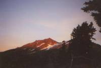
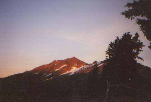
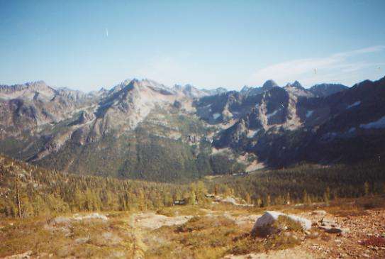
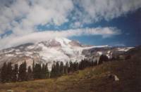
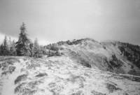
We woke to the welcome sight of blue skies and sunshine. Snow-covered Glacier Peak was visible to the north, and quite beautiful. We could see peaks and ridges in all directions, including a good, though very distant, view of Mt. Rainier. We can’t photograph it, as it looks so insubstantial. It wouldn’t show. There are green flowery meadows and distant red ridges all over. We don’t see as many lakes up here in the Henry Jackson Wilderness. There are a few, mostly small and shallow, but not many. I have really enjoyed the hiking the past couple of days. Sunshine makes such a difference. Taking our time helps too. Since we can’t pick up our food drop in Stehekin until the post office opens on Monday, there is no reason to hurry to get there on Saturday. We’ll aim for a Sunday arrival, which means short days, late mornings and long lunches. When the weather is nice, that’s heaven. The views just keep getting better and better. The rich colors are beautiful. The contrast of red berry-covered ridges against the green valleys and snowy peaks is awesome. We stopped for the night by a tiny pond beneath Indian Peak. It has snow on the flanks, as well as green. The sun is setting on the jagged peaks behind us. It is quite windy, but sunny. We saw several backpackers, a group on horseback and one man with a shovel. I have no idea what he was doing out there, though he may have been a backcountry ranger whose campsite was well-hidden. My imagination gave other explanations.
Thursday, September 14: Fire Creek — 18.1 miles (2524.4)

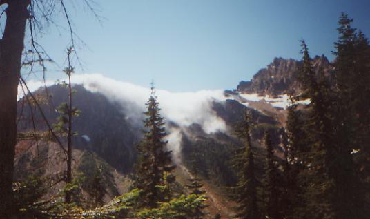
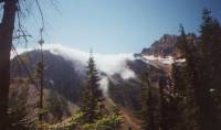
The wind blustered and blew all night, preventing a sound sleep. When we woke, it was still blowing about 30 m.p.h. and made our climb up to White and Red Passes more difficult, though interesting. It wasn’t very cold, just windy. The views from Red Pass were terrific: glaciers everywhere, beautiful peaks above us, and a long glacial valley below. We saw three marmots running from a hawk, a hunter on horseback, looking for bears, two women backpackers and a couple of tents--all before lunch. We started with a 1000’ climb, all above treeline (up to about 6500’), then a long 3000’ descent into damp mossy mushroomy forest, followed after lunch by a climb back up to 6300’. It was cloudy this morning, but cleared up by noon. Yeah!
The afternoon climb was a disappointment because it was mostly in the trees, with few views of the glaciers above us until the end of the ascent. Then the views of Glacier Peak were beautiful. We crossed several streams on logs. Jim slipped on one wet one and jammed his foot between two logs. For a moment I thought he had broken it, but he was able to limp on. Another crossing was a knee-deep milky ford, fast and slippery. We decided to stop early. From here we climb another 1000’ to Fire Creek Pass, then drop down the other side. We had time to do it before dark, barely, but no real desire. So I washed up in the icy creek nearby (snowmelt!), started an early supper in the sun in a small meadow, and made pudding for dessert. Hemlock and juniper trees surround us. We can see a big cliff from our campsite, but not the one below Fire Creek Pass. We saw another falcon this afternoon, but no other wildlife or people.
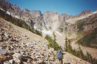
Friday, September 15: Suiattle River — 18.5 miles (2542.9)
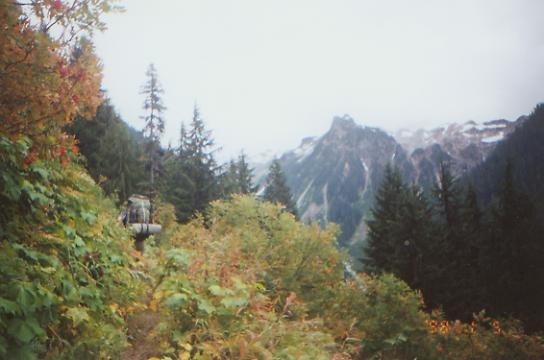
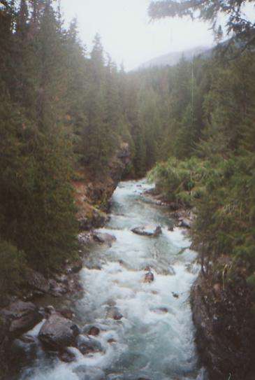
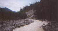
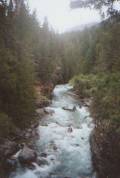
We lost the sun — drat! When we woke, the fog and clouds were back, veiling the mountaintops. We climbed up to Fire Creek Pass, over some snow, then began an interminable descent to rushing Milk Creek. I was glad to see a bridge there. Then we began a steep 2200’ climb up the other side. I saw 12 grey marmots, posing and whistling at us, in the grassy meadows and rocks. There were some views of the glaciers above, a red split mountain, and the long valley below. We spent a couple of hours (including lunch) above treeline, then began the many switchbacks down the far side of Vista Ridge. We were happy to see good bridges across Vista Creek and the Suiattle River — both were raging white torrents. (Glacial melt carries a lot of ground rock, hence the milky color.) Our campsite is a nice one, but noisy with the roar of the river. It does have an outhouse of a sort, a rare thing on the PCT, though we have seen a few in this area.
The biggest excitement today was a wasp nest in a hole in the middle of the trail. Two backpackers going the other way warned us about it. One had been stung six times. His wife was really freaked, and covered herself in her rainsuit even though she must have been broiling on the long climb. We were able to get past the wasps by running fast and jumping over the hole. The wasps swarmed out, but didn’t go far. When they returned to the hole, the next person could run and jump. It took about five minutes for them to calm down between hikers. We all made it safely past the nest, though, oddly, Jim was stung about a mile earlier by a lone bee. It certainly gave us something to think about besides the 53 switchbacks on the way down the ridge. The sun never did come out, so it was rather a gloomy day. The forest near the river is old growth forest, with huge mossy trees. It was damp and dark, but pretty. We only saw five backpackers today, including two who are camped about 50’ away from us. Given the amount of gear they have, they may have come in by horseback.
Saturday, September 16: Five Mile Camp at Pass Creek — 21.4 miles (2564.3)
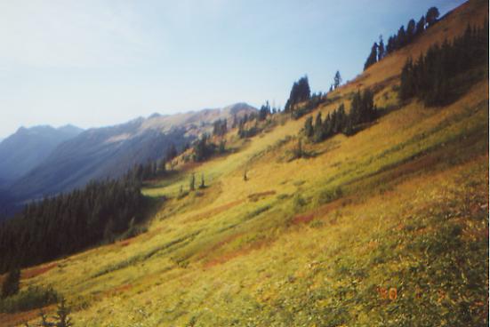
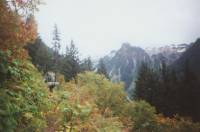
We woke to another grey and gloomy day. Reluctantly, we packed up and climbed into the fog. Soon we were drenched from wet bushes and fog drip off the trees. It was a long but easy 3200’ climb to Suiattle Pass. The guidebook has a beautiful view of Glacier Peak as seen from the pass. All we saw was the usual great white sheet. Once we began to descend though, a strange thing happened — we left the cloud behind. It hung over the top of the ridge, sending tendrils across to the other side, but farther north we had blue skies and sunshine. We enjoyed the views as we circled around two large cirques. The colors were beautiful: yellow ferns, red huckleberries, green moss, and massive white and grey rocks. The walls of the canyon were high and sheer, quite beautiful.
After lunch we descended into the trees and followed the South Fork of Agnes Creek for several miles. Parts were quite dramatic with grey cliffs and tumbling waters. The sun stayed with us all afternoon, though occasionally we could look back and see the large white cloud still hovering over Suiattle Pass. The sunshine helped our mood a lot, though we were all quite ready to stop when we reached the campsites near Pass Creek. A very cold bath woke me up a little, but I’m ready for bed. We’re all ready to go to town, though Stehekin isn’t much of a town. Still it has showers, laundry and hot meals. We may end up camping since the hotel is likely to be expensive, as it’s the only one in town.
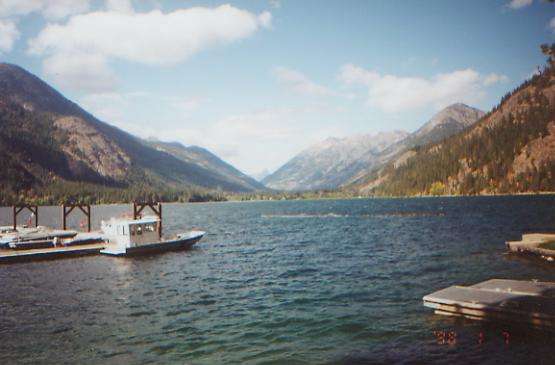
Sunday, September 17: Stehekin — 6.3 miles + 1.0 (2569.4)
We woke late and strolled down the rolling trail to the Stehekin trailhead. There’s a bus that goes from the trails to town twice a day. We were supposed to wait a couple of hours until the shuttle came by, so we settled down to brew coffee and relax until noon. A car came by about 11:00 and we asked them for a lift to town. Five of us (Ken and Marcia, Sly, Jim and I) jumped in the back of the truck for the eleven-mile ride to “town.” It was a pretty drive. The Stehekin River is clear, blue, and fast, with steep grey cliffs looming above, and looks a bit like Yosemite. Stehekin is a small resort at one end of Lake Chelan. The only access to it is by foot, boat or float-plane. There are a few houses, a lodge with a restaurant, a couple of small stores, a post office and a bakery that is very popular. About nine miles out of town there is another lodge with small cabins for rent. The locals have cars, but tourists travel by shuttle-bus. There is a free campground nearby, with tiny little tentsites. We’re sharing a site with Sly and Cheryl, who came in on the ferry. Things got a bit hectic, as we were trying to get laundry and showers done in time to get out to the bakery before it closed. We didn’t make it. We had to make reservations for dinner at the lodge. How absurd, but it’s the only restaurant in town. The other lodge nine miles outside of town offers dinner, but they were full up. I had hoped to stay over a day, maybe taking the ferry out on the lake, but there is a storm brewing, so we’re heading back to the trail.

The group we met in Big Bear, known as the Menacing Vegetables--Ben and Ezra, John and Maria—showed up this afternoon. They flip-flopped from Seiad Valley to Manning Park. They only hike about 15 miles a day and never really expected to finish the trail this year. The group decided that they would rather hike through Washington than Oregon, so jumped north to Manning Park and are heading south to Cascade Locks. One of the guys sounded interested in finishing the trail, even if it meant hiking through November, but the rest seemed pretty sure they would quit when they reached Oregon in October.
Monday, September 18: Six Mile Camp — 11.4 + 2 miles (2580.8)
A good dinner and good breakfast almost made up for a nearly sleepless night last night. It was windy and hot, a bad combination. We walked to the bakery this morning, bought bread, sweets and a slice of pizza for lunch, and then caught the shuttle bus back to the trail. We had a bit of a problem finding the trailhead, thanks to a sign that pointed in the wrong direction, but eventually we got back on track, starting at about 12:30. It was cool and cloudy, with occasional blue “sucker holes” overhead and glints of sunshine. Jim and I saw a tiny rainbow over Lake Chelan as we walked the two miles to the bakery — a good sign? About five miles out we passed a small campground where we ran into Meadow Ed, a very well known PCT personality. He lives in southern California and spends the spring months meeting thruhikers and putting out water caches. Oddly enough, I had just remarked to Sly that I was sorry we had not met him down south when we passed through Kennedy Meadows, when we came around a corner and there he was. We sat and talked for quite a while, then reluctantly donned our heavy packs for another six miles.
The trail follows a river, rarely close, but near enough to see steep grey cliffs dropping down to the water. It’s very dramatic. The only other excitement was a short swinging bridge with considerable sway and very low sides. I usually like suspension bridges, but this was a bit much. We met about 15 backpackers, plus the crowd on the bus, for whom we were the day’s entertainment — “real PCT hikers.” Most were just heading for the Stehekin Valley Ranch, though a few were going on day hikes and a few were just riding the bus to see the valley.
We’re glad to be back on the trail, despite our newly heavy loads. It’s hard to believe we’re so close to finishing. This is the last section of trail. People congratulated us on nearly completing the Triple Crown (hiking the AT, PCT and CDT), but it all seems so unreal. We didn’t come out here to get a plaque. We came to explore the natural beauty of the mountains. But right now, Jim and I are tired. In some ways, I think we’re ready to go back to “normal” life, at least for a while, but I know we will also miss our “real” world out here. There is so much beauty in the mountains and the deserts. I find it hard to find beauty in the city, of any kind. Plus, I really hate living by the clock, and that’s so much a part of that other life. Living by the sun has its own problems, but there are usually a lot more options. If we don’t hike as many miles as we planned, no problem, we’ll do more tomorrow. Or maybe not, it really doesn’t matter. I still love hiking, camping and backpacking. I like the people we meet out here, at least the ones we’ve been able to visit with a bit. Many of the fastpackers won’t take the time to talk. I figure if they won’t take five minutes to say hello, then they aren’t usually worth talking to anyhow. I love the closeness Jim and I share. Before we started on the CDT, I worried that too much togetherness would put stress on our marriage. It hasn’t happened. We seem to be closer than ever. Thruhiking is a very simple life and a good one, despite the problems of sore feet, heavy packs, rain and sleet and very long mileage days. The challenges are mostly physical, and real, and much easier to deal with than the emotional complexity of city life. I’ll miss this life. We had a hard time coming to terms with the PCT, but overall, the moments of harmony more than make up for the frustrations.
Tuesday, September 19: Camp between Granite and Metnow Passes — 18 miles (2598.8)

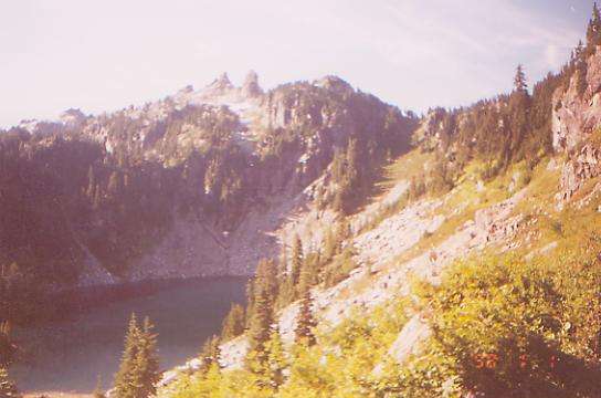
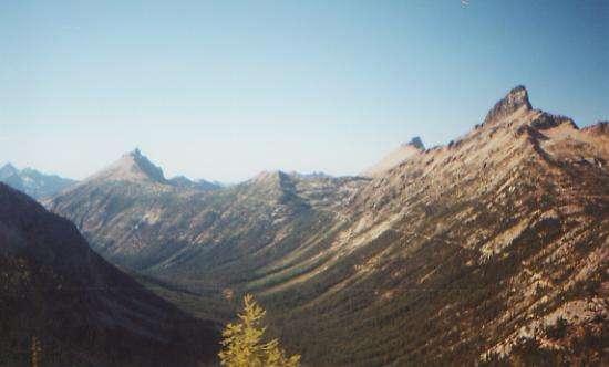
It’s a beautiful day, sunny and cool. I was really happy to see the blue skies after yesterday’s clouds and sprinkles since we were told that the area north of Rainy Pass was spectacular. It is, and for once we got to see it. First we climbed gently through the trees along Bridge Creek, then we crossed the highway at Rainy Pass (our last paved road until Manning Park), then we climbed steadily up to Cutthroat Pass. It was beautiful when we climbed above treeline -- stark ridges, autumn colors, blue skies — beautiful! There are larch trees here, just starting to turn yellow. Odd, I’ve run into them in Pennsylvania and Montana and now Washington — such different environments. Our campsite tonight is high in a little valley, with golden cliffs above us. Most of the trail this afternoon was high and exposed and very beautiful.
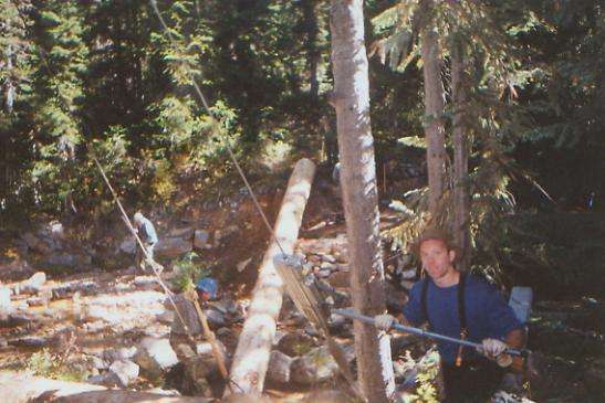
We met a new thruhiker named Jake. He has very holey shoes, no socks and sleeps right on the trail every night. Different. We saw a bunch of dayhikers and some people camped with llamas near Cutthroat Pass. Best was meeting a trail crew using a come-along to move a big log into place for a bridge. There were partly volunteer crew (Audubon Society) and partly professional Forest Service crew. I didn’t tell them that I wouldn’t use their bridge when it was built — too narrow and too high. I’d rather wade the creek.
Wednesday, September 20: Camp before Harts Pass — 19.8 miles (2618.6)
We woke to the slithery sound of sleet on the tent. This despite the fact that at 10:00 last night there wasn’t a cloud in the sky! It rained off and on, but never very hard. We slept a bit late, then climbed to Methow Pass, then dropped down, down, down to the Methow River. Lunch was under a bush next to Brushy Creek. It was grey and damp, but not actually raining then, though it sprinkled off and on all morning. Mostly we were in the trees, though there have been several avalanche chutes that gave us views up and down the valley. The tops of the peaks are cut off by clouds, but it is still pretty with the autumn leaves.
After lunch we climbed above treeline and into the clouds. It continued to rain a bit, but was mostly just grey and gloomy. We could see little except a couple of fat marmots, changing into winter coats. Right now they’re tri-colored. It was a long climb with innumerable switchbacks. Occasionally the clouds would part and give us a partial view of red rock and green forest. For a while we walked along a narrow ridge. That was fun, even without a view. Descending a bit, we got a glimpse of the valley below. There was one arresting image of the ridge across from us, with white clouds behind the rocks, making them really stand out. Beyond was another ridge, with clouds behind it. It was gorgeous.
Late in the afternoon, the clouds finally cleared, more or less. We walked down a road to a campsite near a small spring. We can hear other people car-camping nearby. Sly decided to keep going another mile or two. I’m not sure whether or not he’s mad at us, and if so, why. He just left. Jim and I decided 19 miles was good enough for a wet day, and decided to take advantage of the water and picnic table. We actually built a fire in the fire ring. It’s something we rarely do, especially on our long hikes. But I was cold after being drizzled on all day, there was a big dead branch across the road, and it was kind of a celebration for being so close to the end of the trail. It rained again as soon as we started dinner, and soon put the fire out. I wonder what tomorrow will bring. More rain? Sun?
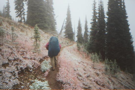
Thursday, September 21: Hopkins Lake — 26.1 miles +1 (2644.7)
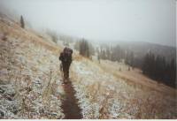
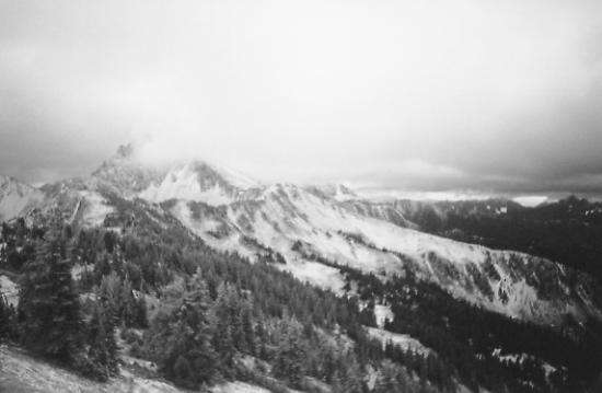
Last night’s rain turned into snow by morning. There was just a dusting when we woke, but it was a preview. While I cooked breakfast, it began to snow in earnest. What to do? We packed up and walked the mile to Hart’s Pass, our last bailout spot. A dirt road to Mazama passes by there, and since there were several people hunting in the area, it would have been possible to get a ride to town, if we chose. Outside the ranger’s cabin there was a posted forecast that said that the next few days would be “clear and sunny, but colder.” We hoped that meant the snow would quickly end. It didn’t. Though it didn’t snow very hard, it continued all day. Still, accumulation was minimal, from a bare dusting to about 6” in drifts. It was pretty, dusting the plants and peaks. Everything stood out: the red leaves of the mountain cranberries nestled in a white powder, lightly frosted spider-webs, Queen Anne’s Lace, with a lacy pattern on the leaves to match the white lacy flowers, and white spruce, looking like a Christmas card. Most of the day we couldn’t see very far, but late in the afternoon the clouds lifted enough to give us some really awesome views of white mountains nearby. Someday we’ll have to come back and see what this section looks like. A lot of it was above treeline, and probably quite beautiful.

It was a busy day on the trail. Yesterday, all we saw was one runner; today we saw 16 people, eight mules, five horses and four dogs. The horses were a group of hunters. Two of the mules belonged to a trail crew that was actually plowing the trail. Different! The only wildlife we saw was several grouse.
We ended up going farther than planned. Because of the uncertain weather, we wanted to get beyond the section’s 7100’ high point, just in case it continues to snow. We’d hate to be turned back this close to the border! As icy as the trail was in spots, I’m glad we kept going. In the morning, the whole thing is likely to be an icy slide. We’re protected in the cirque around Hopkins Lake and out of the wind. Whatever happens tonight, tomorrow we’re going to Canada!
Friday, September 22: Manning Park, BC -- 15 miles +1 mile (2658.7)
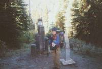
We crossed the border into Canada at 11:00 a.m. There was lots of excitement, hugs, and smiles. Last night was very, very cold. We slept little as a result. But when we woke, the sun was shining, melting the ice on the tent. It was far from warm, but at least it felt warmer. We crunched on rime ice all morning. Late in the morning, we stopped to take a snack break. When we got up and went around a switchback, we discovered that we had stopped about 100 yards from the monument at the border. We took pictures, read the trail register hidden inside the monument, and headed into Canada. The day’s hike was easy, first downhill seven miles to the border crossing, then uphill for about 3 ½ miles over a ridge, then down to the park. There were a few nice views, but mostly we just walked in the trees. It’s funny how the passes in Washington are so well named. It was cold on Frosty Mountain, windy on Windy Pass, foggy at Foggy Pass and cloudy at Cloudy Pass. Only Rainy Pass wasn’t prophetic for us, but I think we just got lucky.
Home | Links| Trail Journals |
The Thruhiking Papers | Bun-bunSouthern California | Central California
Northern California | Oregon | Washington
Created: 16 Jan 2004
Revised: 30 Sept 2016Copyright © 2000-2017 Spirit Eagle