|
|
|
 |
 |
 |
 |
|
|
|
|
|
|
|
|
The Pacific Crest Trail
Castella to Ashland
Saturday, July 22: Castle Crags State Park @ 2.5 miles (1502.0)
It was an unexpected day. We went to breakfast at the Black Bear Diner, then to the outfitter store where we bought lightweight boots and met Guy again. Kerstan is one day ahead of us. An AT friend, Mike Henderson, met us there. He lives in Eureka, about 3 ½ hours away, but came to visit. He drove us back to where we left the trail, then went on to wait for us at the State Park. We walked the couple of miles to the campground, which has a site specially set aside for the PCT hikers. It’s a noisy one, with the constant roar of the freeway and railroad traffic nearby, but otherwise it has been peaceful and cool. There is no one set up in the nearby sites, so we have this corner of the park to ourselves. We chatted with Mike all afternoon, bought some chili at the store at Castella, just outside the park gates, and walked back to the campsite in time to watch Sly and Cheryl drive up. They just finished the next section and had come back to retrieve their car. So we sat and visited with them for a couple of hours. About 8:30 Starman, a PCT hiker we had met briefly in South Lake Tahoe, showed up. It was a fun sociable day, quite restful in its way. We hadn’t planned to take a day off here, but since Mike was willing to come all that way, we were happy to take the rest. And given our chafing and sore feet, a quiet day was good for us in other ways as well. We saw a rattlesnake and a buck in the short stretch we walked into the park. It was a nice day.
Sunday, July 23: Upper Gumboot Lake @ 24.4 miles (1525.1)
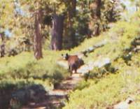
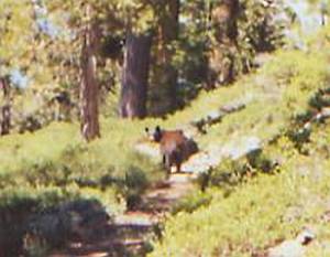
We saw our first PCT bear today. Finally! I heard a rustling in the leaves above us and stopped to see what it was. Instead of the deer or squirrel I expected to see, I spotted a dark brown bear headed down the hill straight toward us. It hadn’t seen us, but when I yelled, “Yo, bear!” it turned around and ran back up the hill. There were bear boxes at the campground, but I didn’t really expect to see any bears. That was fun.
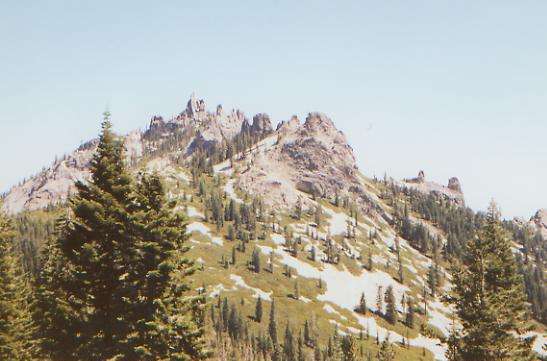
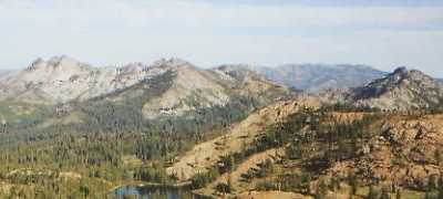
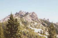
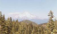
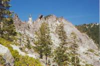
All morning we climbed, first very gently up and down in the park, then more seriously up past the crags. There were intermittent hazy views of Castle Crags as we climbed. They’re big open granite peaks, very like the domes in Yosemite. It is really beautiful despite the smog. We don’t actually climb among them, though there is a side trail we could have taken. It is enough right now to look up and see the jagged peaks. This next stretch is a couple of thousand feet higher than the last section was, and should be cooler. We’ve been walking in live oak and manzanita off and on all morning, but will climb up to sugar pines and whitebark pines — shady trees — this afternoon. I’ll be glad to leave the poison oak and rattlesnakes behind, as well as some of the heat.
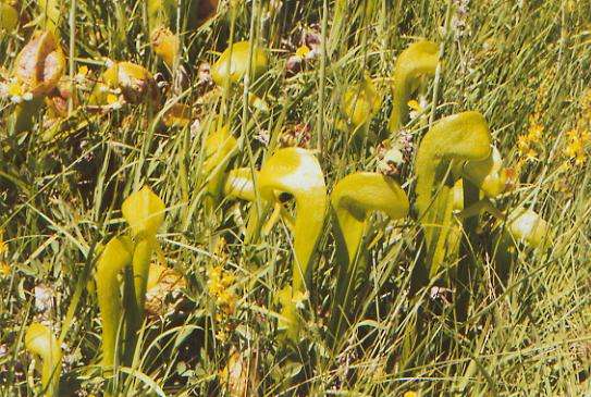
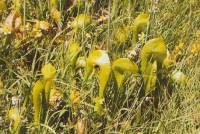
Later: We didn’t actually find much shade. We were mostly out in the open, wading through manzanita and other brush. It makes for nice views, but hot hiking. We had great views of Castle Crags, Shasta, and even as far south as Lassen Peak, plus new views of jagged mountains to the west. We climbed high along a divide for much of the afternoon. Late in the afternoon, there were a few lakes below us, but they were hard to reach. We ended up at Gumboot Lake, which is only about 250’ below the trail, much better than the earlier lakes we passed. We’re both tired and sore. Jim’s foot was really causing pain today. It doesn’t like first days out of town, maybe because the pack is so much heavier. Still it was a good day with all the ridge-walking and beautiful views. Our lake isn’t even all that buggy, despite being very shallow. There’s another larger lake nearby, but we could hear voices over there, so we decided to come to the smaller one. We saw some new flowers — little green pitcher plants — plus some azaleas at a spring. Jim saw a deer sneaking away while I went to get water. It’s funny how they do that. They look so furtive.
Monday, July 24: Bull Lake — 22.6 + .5 (1547.8)
We slept late, until almost 7:00, when the sun’s heat forced us out of bed. We don’t want to rush this section as we don’t want to end up in Etna on Wednesday evening. If we arrive the next morning, we’ll have all day to take care of chores and rest, but will only have to pay for one night’s lodging. The morning hike was fairly easy: some gentle climbing, lots of hazy views, and a couple of lakes below the trail. We had a nice view of Toad Lake with Mt. Shasta rising beyond it. Lunch was at sparkling Deadfall Lake. Lots of red rock all around there. There’s a little snow up above and we crossed one drift this morning. We followed a deer up the trail for a minute or two. There are lots of wildflowers, especially around the springs. The breeze is cool. I’ve really enjoyed this section.
There were an amazing number of dayhikers around Deadfall Lake. The trailhead is only three miles away, the trail is almost perfectly flat, and it is beautiful. I guess I shouldn’t be surprised at the crowd. Our afternoon hike was also mostly level, contouring around a stream basin. Then we started south. For some reason, we head south for the next 40 miles. Why? Still it was easy walking, with some interesting rocks: red and black boulders, green mica, cemented glacial moraines, etc.
Best part of the day was a swim in Bull Lake, which we have to ourselves. It felt wonderful. A breeze is keeping the bugs at bay. Such peace and quiet. It’s lovely. The jumping fish are the noisiest thing out here.
Tuesday, July 25: Meadow at 1570.8 — 23.25 miles
We had a quiet morning, mostly contouring around ridges. There were some lovely views of the snow-covered Trinity Alps to the southwest. Also, some not so lovely views of clear-cut forest. It’s hot again, so the forest stretches feel very nice, though they have no views. We saw Starman again, off and on. We saw another bear as we rounded Scott Mountain. It was another young one, thin with dark brown fur. It was walking up the trail in front of us. When it heard us, it ran off the trail, then stopped to watch us. It walked beside the trail for a minute, then went down the hill. That was fun.
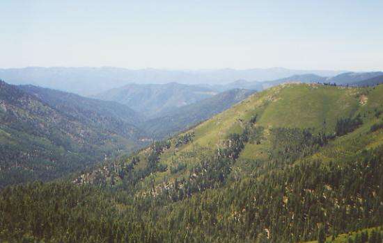
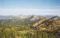
The afternoon had lots of good views of rugged saw-toothed mountains. Shasta continues to appear from time to time. There were lakes and ponds and occasional snow patches. All in all, it’s beautiful country. I like Section P best of all the sections in California so far. At the end of the day we found a tiny creeklet in a green meadow. There were four or five deer grazing below, but they left while we were setting up. All in all, it was a good day.
We met a group on a three-day bike tour at Scott Summit. Their support vans were giving out water, fruit, cookies etc. We talked a bit and got some water, but didn’t manage to yogi anything else. We must be losing our touch. We met a man out section-hiking with his 70 year old father and teenaged son. Dad has only 200 miles to go to finish the PCT in California, so they’ll spend the next two or three weeks doing that, using a car to break it up into short two-day sections.
Wednesday, July 26: Payne Lake -- 23.5 (1594.3)
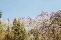
It was a lovely morning, with beautiful views and lots of springs. There was a lot of steep up and down, both on and off the trail. Many of the ridges and peaks come to sharp points. There are also lots of glacial bowls. They’re related. This was an active glacial area, and there are a lot of signs of their activity.
I’m feeling happy and peaceful, but hungry. I’m ready for town tomorrow, but also a bit sorry to end this section. It has been a good one for both of us. Seeing the bears helped; it felt more like a wilderness than anyplace else we’ve seen in California. Having lots of water and lots of nice options for camping also made this a nice section to walk. No death marches were necessary. We could have pushed to get to town in four days, but we both agreed not to even try. Yeah!
The afternoon was much the same, with some good views of glacial cirques, granite cliffs, and green forest. The climbing was greater than expected — lots of up and down — but the views were worth it. We saw one deer, who wasn’t at all afraid of us, and some cows with bells on, clanging with every step, and some friendly dayhikers and two more backpackers, plus the section hiking family we met yesterday, heading south. It was a busy day. This area feels like wilderness, but isn’t quite, though it’s called the Russian Wilderness. It looks a lot like the Sierras, but wilder. We finally stopped for the day at a long narrow lake in a steep-walled valley. The guidebook said there were no campsites for another half mile, but was, fortunately wrong. It felt good to get cleaned up, though I didn’t go for a real swim this time. It was too late and too windy. It’s not much of a site, but it will do.
Thursday, July 27: Etna — 5.9 miles (1600.2)
We had a peaceful night by the lake, listening to the fish jump. I had fun filtering water, watching three big tadpoles try to make sense of the bobbing pre-filter. They couldn’t decide whether it was friend or foe. Their curiosity was amusing to watch. From there we had a lot of climbing, just to get up above a small lake, but then afterward there were other views that were terrific.
We had a long wait at the highway for a ride to town. There were only three cars in two hours that were headed our way. A construction driver going the other way, who saw us yesterday when we crossed a road 20 miles back, offered to pick us up if we were still there when he passed by 3 ½ hours later. Fortunately, a local man who runs a kayaking school picked us up eventually. In town, we got a sandwich at the deli, went to the post office to pick up some new pants and socks I had ordered from REI to replace the holey ones I’ve been wearing, and got a room at a local B&B that is very hiker friendly. Joyce Bradley has a beautiful home and is very particular about things like no boots or packs in the house, so she opened up a hostel in the barn for $12 night. She said we could stay in the house if we were willing to leave the smelly gear outside. We opted for clean sheets, even if it is more expensive inside the house. We spent the evening out on the porch talking. There are five other guests here, including a couple who are acting as trail support for their daughter and son-in-law, a guy on a motorcycle and a man and his father who came to look for an old friend of the father’s. I may have met the son at church in San Francisco, many years ago. Small world. Dinner was another sandwich at the deli, then ice cream out in the garden by the fountain. Jim wasn’t in the mood for Thai food, which was the only other option within walking distance. It is a lovely garden. Just for fun, I climbed up into the tree house. It was a nice stop.
Friday, July 28: Cold Spring -- 21.1 miles (1621.)
We got a ride back to the trail with a neighbor of Joyce’s, a retired forest service fire fighter, and his two-year old grandson. He was driving by, saw us, and decided he had nothing better to do than drive a steep winding mountain road 20 miles out of his way. Trail magic.
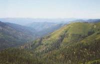
Though the trail was often high, with lots of open views, it was hard to get excited about them. Partly it was the haze, partly that the ridges were just green tree-covered mountains, not dramatic granite spires, and partly we were just tired from too little sleep and full packs.
Water was non-existent for the first ten miles, although the guidebook referred to springs and streams. That has been rare for us on this trip. Usually there are more creeks than mentioned, not less. For a while this afternoon, that was the case. One section still had snow patches above, so it was rife with springs and streams and beautiful wildflowers. The flowers were good all afternoon. I liked the orange lilies especially. There were a few lakes below us and a couple of tiny ones next to the trail mid-afternoon. We started late and so ended late - 7:45 p.m. It didn’t help that we missed the first of two junctions to the spring and had to do an extra 4/10 of a mile to the next one. We saw two backpackers with Russian Wolfhounds headed south. We found an informal trail register on the trail today. Eleven people signed it in the past three days, plus us. Kathy is getting off the trail at Ashland. It’s not a surprise. Last time we spoke, she said that the hike was putting unexpected stress on her husband and her marriage, and she didn’t want to risk losing them. Not unusual for thruhikers. I think she got out of the hike what she was looking for, in any case. A lot of the hikers out here end up just doing California. It is such a big state. When you’ve hiked 1700 miles, and realize you still have two long states to go, that can be hard. It’s a bit like the AT hikers who quit in Gorham, NH, right at the Maine border. They’ve hiked so far, but still have 250 miles to go, and they decide that enough is enough. For us, it’s almost the opposite. At the Oregon border, it becomes, “only a thousand miles to go — piece of cake!”
Saturday, July 29: 22.2 miles (1642.9)
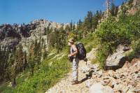
We had a beautiful morning, wandering through the Marble Mountain Wilderness. The rock really is marble, a very light grey that contrasts with the darker volcanic rock above it. Flowers are everywhere, often waist to shoulder high. It makes for slow going, since we can’t see the rocks and holes underfoot, but it is pretty, with white Queen Anne’s Lace contrasting with orange paintbrush and blue lupine. A lot of the trail was out in the open, with views in all directions, especially of Black Mountain. We started late (8:00) and very slow, but otherwise it was a good day. We saw lots and lots of bear scat on the trail, but no sign of Yogi Bear.
At lunch we watched five hummingbirds chase each other about, stopping from time to taste the flowers in front of us — a purple clover of some sort. A family passed us as we ate lunch to go for a swim in tiny brown Paradise Lake, and later we saw a backpacker headed toward Castella, but mostly we had the trail to ourselves. We climbed up to an open ridge, which we followed for several miles. It was covered in short sage and wildflowers, with beautiful views. A rocky red ridge paralleled our route for a while. We saw masses of blue butterflies, drying their wings in the sun, fluttering up as we passed by. A small hawk, a bit larger than a falcon, but not much, soared overhead, as did a quartet of dragonflies.
Then we began a very long descent in cool woods. Some old logging roads provided an unexpected treat: ripe strawberries (tiny but delicious), blackberries (though only a few were ripe) and thimbleberries (a bit mushy, but tasty.) We stopped early, thanks to sore feet, a bad case of chafing (my hips are raw) and a good sure site versus an iffy site up the trail. I’m too tired to pass up a sure site even though it will make tomorrow longer. We took a very cold bath in the creek, washing away the salt and soothing our various hurts. It felt good.
Sunday, July 30: Seiad Valley — 14.1 miles (1657.0)
We woke early and began the trek toward town along Grider Creek. It was a good thing we stopped early yesterday, as the next campsite had been flooded out and was basically just a wide spot on a gravel bar. Last night Mike and Debbie showed up just before dark. They had walked 32 miles that day. She’s a former nurse and only 4’11”. He was career Army until he retired this year. They’re both about 50, I guess. It was too late to talk last night, since they were trying to set up in the dark, and they took off early this morning, so we never got a chance to do more than say hello. With the mileage they’re doing, we won’t get a chance to talk to them again. We talked to Debbie’s parents--who are giving them van support--at the B&B in Etna, which is why we know the little we do. So many people are into doing big miles out here. I don’t know why, since it isn’t really necessary to hike 30 miles a day to finish the trail. But a lot of hikers enjoy pushing themselves to their limit. I just like enjoying myself, without pushing. There’s enough tyranny in doing 20-mile days, I don’t need to add to it. Different strokes, I guess.
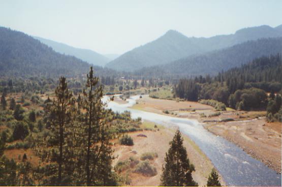
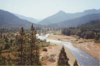
After following the creek for eight miles, we began the six-mile road-walk into town. It turned out to be a surprisingly nice walk. The road was lined with blackberry bushes. We grazed as we hiked — a handful here, a handful there. Heaven! Two hours later, we were absolutely stuffed, covered in purple juice from fingertips to elbows, and quite happy. The road follows the Klamath River, crosses a bridge, then doubles back. We kept looking down at the water, thinking, “I bet we could cross here. It would save a lot of backtracking.” But the guidebook specifically warns against doing that, so we just walked the road. It was hot though, and the water looked awfully inviting.
We reached Seiad Valley around noon. There isn’t much there — just an RV park with shower and laundry, a small café and store. There used to be a lodge down the road with a bar, but it was sold recently and hasn’t reopened yet. We ate lunch, but since the café closed at 2:00 (four hours early) we just bought a can of chili at the store for dinner and some ice cream. The RV park lets PCT hikers camp there, or they have a small bunkroom with a fan and two beds. It had a TV with VCR, and free movies, so we took the bunkroom. The fan was the big attraction, as it’s 105° outside, so we settled in for an evening of chili and "Galaxy Quest." Another hiker, Mark Davis, showed up and decided to camp outside, though we invited him to join us in the relatively cool bunkroom. We considered hiking on this afternoon, but given the heat and the 4400’ climb out of the valley, we’re happy to wait until morning.
Monday, July 31: ridgetop -- ~19 miles (1676.0)

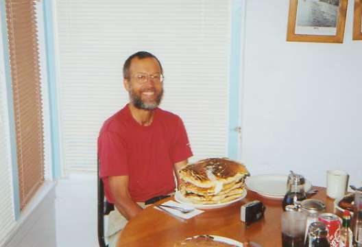
Seiad Valley is famous for its “pancake challenge.” If you can eat five of their enormous pancakes, then you get them free. Only four people have ever succeeded, though many try. When we heard that Mark intended to try the challenge, we decided to hang around and watch. Mark gave up after three pancakes. They are huge. We each ate one, with eggs and sausage, and barely managed to finish that. They were good, just big. Another hiker, Ed, showed up while we were eating, and didn’t even manage to finish one, so Mark’s attempt was a good one. According to the register, the best attempt so far this year has been 4 ½, and that was a section hiker, just starting out. Mark is taking the day off. I don’t think it would be possible to climb out of the valley after trying the challenge. The cook said the all-time champ was a German who ate six, then came back a couple of hours later for an omelet.
Anyhow, it was 9:30 by the time we left town, after a visit to the post office to pick up some cookies Dave had sent us. About a mile up the road, I realized we had left our small water bottles in the fridge in our room. Jim went back for them, while I kept an eye on our packs. Fortunately, Debbie’s parents gave him a ride back to the trail, so he didn’t have to walk the road both ways.
The climb was as bad as we expected — nice trail, but very very hot. It is six miles to a spring, where we filled our now empty bottles, then we managed lunch in the shade of one of the few trees that didn’t burn in the fires in 1987. The views were nice, though it was very hazy. We could see Kangaroo Peak to the north, Shasta and the Seiad Valley to the south, hazy blue and green ridges all around. It’s mostly manzanita in the fire zone, making for scratched legs, but with a scattering of pines and firs. We were drenched with sweat. We got our shower from the inside this time. There’s still some climbing to go, but we’re back above 5000’ again. Town was only 1300’. We passed the point today where we only have 1000 miles to Manning Park. Out here, that’s a major milestone. Tomorrow we hope to hike into Oregon. It’s progress.
The climb continued after lunch, past rocky Lower, Middle, and Upper Devil’s Peaks, red Kangaroo and Red Butte Peaks. Jim saw a doe and fawn in the brush. There were a few small springs, but only the well-named Lily Pad Lake had any appreciable water, though not enough to swim. We decided to cook dinner at Cook and Green Pass, near a spring, then move on afterwards. The next water was too far to get to tonight, especially with the 1200’ climb after the pass. We hiked until almost dark, then found a clear spot on an open ridge where we could watch the stars and set our sleeping bags out in the open.
Tuesday, August 1: Wrangle Gap — 24.4 miles (1700.4)
Our open campsite was a dewy one. We woke up soaked. Still, it was worth it to watch the stars last night. We slept well and long. The morning hike followed ridges, with lots of open space and nice views. Water was scarce, and mostly off trail, so we made do with what we had. We met a section hiker, out to hike Oregon at 10 miles a day, and the father-son team we met a week or so ago. Ed passed us. He’s averaging 30 miles a day, and not planning to visit Ashland, so we won’t see him again. He was a nice guy though.
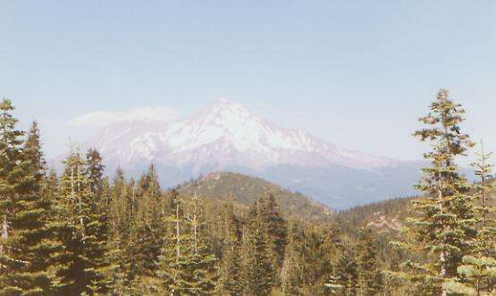
Shasta looks surreal, like a holographic image superimposed on blue sky. Only the snowy outline really shows; the blue ridges blend into the hazy background.

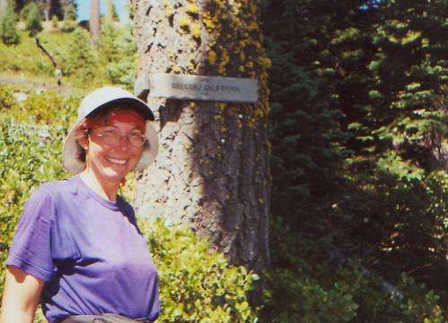
The afternoon was mixed, with some flowery ridges, some heavily logged forest (including some currently being logged), and some green grassy meadows. We heard cow bells frequently, but only saw one herd, at Donomore Meadows. The highlight was reaching the Oregon border, after almost 1700 miles in California (more if you count off-trail miles, which we don’t.) It was in the middle of a logged over hillside, so I was afraid we’d miss the border, but there were big signs and a trail register. We went on to a nice spring to cook dinner, with the intent of moving on afterwards. The next water is in 13 miles, supposedly. The view is nice, albeit hazy. We considered camping at the spring, but it was too early to stop. I did wash some of the dust off, at least. We ended up right next to the road at Wrangle Gap since the trail is all sidehill for the next four miles and there won’t be any place to camp. At least the road doesn’t get much traffic. We saw three deer in the meadows and scared one herd of cows.
OREGON
Wednesday, August 2: Callahans — 21.1 miles (1721.5)
We slept well, despite two jack-lighting pickups that drove by just as we were going to sleep. The morning was nice, with some up and down, but mostly easy contouring through woods and grassy flowery meadows. There were lots of tiny streams to keep the grass green and the flowers bright. We saw blue monkshood, orange tiger lilies, cow parsley, lupine, purple asters, etc. We met a group of dayhikers who stopped to talk to us. It turned out Jim had worked with one of the men several years ago. Small world.
We ended up at Callahans, a hotel and restaurant by the freeway that leads to Ashland. The owners--Ron and Donna--are very hiker friendly, giving hikers a discount on rooms and a free beer upon arrival, whether or not we stay, and rides to town or the trail. It is a bit expensive but very nice. We had a late lunch/early dinner out on the deck next to a waterfall and beautiful Japanese maple. It is very peaceful.
Thursday, August 3: day off in Ashland
Home | Links| Trail Journals |
The Thruhiking Papers | Bun-bunSouthern California | Central California
Northern California | Oregon | Washington
Created: 16 Jan 2004
Revised: 30 Sept 2016Copyright © 2000-2017 Spirit Eagle