|
|
|
||
 |
 |
 |
 |
|
|
|
|
||
|
|
|
|
The Pacific Crest Trail
Cascade Locks to Snoqualamie Pass
Thursday, August 23: Day off in Cascade Locks
After talking to friends and family, thoughts of the future and worries about the present intrude. A part of me is already in that other, outside world. My natural world is much safer and happier. As difficult as it is to hike 23 miles a day, it is still easier than dealing with illness, monetary uncertainties, and fear of the unknown future.
When this is over and we look back, I wonder what these travels will have meant to us? What effects will they have on our lives, our attitudes, and our future? I had such hopes: that living simply would bring serenity and wisdom, a reconnection with what really matters. To some extent, that has happened. How much remains to be seen. We know long distance hikers who never seem to grow beyond their first hike. Over and over they go back to relive that first adventure — not really growing or learning, just repeating one great experience. I would hate to do that. Each of our hikes has been different, as we have been different. I have felt internal changes which I take to be growth. But it seems to me that the experience, in order to really mean anything, must extend beyond the time we actually spend on the trail. At the same time, it is unrealistic to expect a long hike, no matter how intense, to fix all the broken pieces. I wish it could.
It is easy to enjoy beautiful views, flowers and wildlife, all the good parts of long distance hiking. And the difficult aspects make good stories, at least in retrospect. We’ll look back on 25-mile days, 30-mile waterless stretches, snowy passes and raging rivers with pride and belated affection. But it all means more that just five or six months of “adventure”. The lessons learned go beyond the trail, I hope. The closeness Jim and I have experienced goes far beyond our hours on the trail. Inner peace, learning to play, appreciating the simple pleasures, taking time to enjoy life instead of rushing through it, persistence despite physical and mental difficulties, a willingness to take chances, to confront fears, to step outside the normal boxes, to explore beyond the safe boundaries of regular life — those are a few of our trail lessons. What other lessons? How will they affect our lives? Can we hold onto them in our other lives? Of course, the two years of hiking may have changed me so much that I can no longer fit into the normal world. That is quite possible. All changes are not positive ones.
August 24: Day off in Cascade Locks
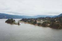
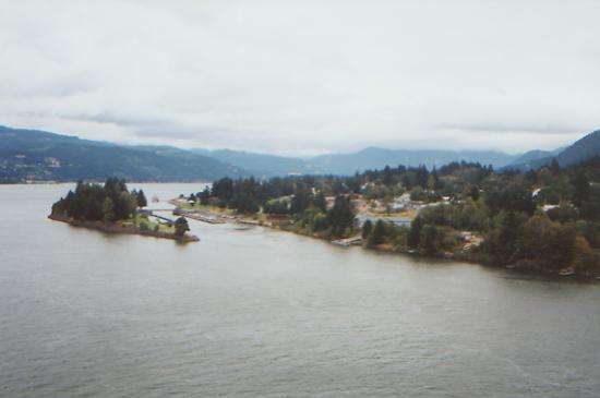
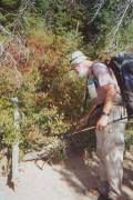
It was a busy day for a rest day. We bought groceries for the next three weeks and repackaged them to send out to towns along the trail, then tried, unsuccessfully, to get Internet access at the library, and did laundry. At the grocery, we met Firefly, whom we had met a few years earlier, and Gepetto. They are hiking Oregon and Washington, and have been just ahead of us since Ashland. We talked to several other hikers in town: Weathercarrot and Laura, Steve, Sly and Cheryl, Alan, Ann, another hiker named Steve, Don the Abominably Slowman, Redgoat, etc. Evidently we missed several others who zipped through town, including Lady Godiva, a thru-rider. She wants to be the first solo woman on horseback to thruride the PCT. I can’t understand not taking at least one day off here. It’s a nice compact town, with decent food and resupply, and even a free place to camp down by the Columbia River for the low budget hikers. Some may be stopping in one of the towns across the river. Most of the hikers seem to be taking a long roadwalk alternate route out of town. It’s much shorter and with less climbing than the PCT, but it is still paved roadwalking through towns. We aren’t in that much of a hurry. We’ll follow the trail.
Cheryl took us all out to the Bonneville Dam, about four miles away. From an underwater viewing area, we watched the salmon trying to head upriver. Some of the fish were absolutely enormous, the size of a large dog. A few seemed to hover by the window, watching us as we watched them. It was fun. Volunteers count the fish as they pass the windows. There were also videos and photos of the building of the dam in the 1930’s. We didn’t take time to check out the powerhouses or the canal locks, though we got glimpses of both. Mostly it was nice to just be out in the sun and the cool wind, lollygagging along, packless and free. We’re not ready to leave town, and we have time enough, so we’re taking tomorrow off too. Maybe we will actually get some rest? WC and Laura are taking a couple of days off in Portland, but Sly and Steve will head back to the trail tomorrow.
August 25: Cascade Locks @ 2 miles walking through town
Saturday, August 26: Rock Creek -- 21.9 miles (2271.1)
Back on the trail again, after a very pleasant two days off. Yesterday we slept in, ate a lot, checked our e-mail at the library, visited the Marine Park by the river and ate some more. It was very relaxed and easy, once we got our mail-drops mailed out. Ken and Marcia were the only thruhikers in town yesterday, besides us. We met them briefly at the campground by the river. There were lots of blackberries on the bushes in town, warm and sweet, like pie on the vine. Simple pleasures are the best!
Today we ended up back at the Post Office, though it was supposed to be closed on Saturday. Jim’s daughter Michelle told him last night that she had sent some brownies. We called the Post Office, and sure enough, they were there. The Postmaster said to come on down and he would open up for us. Trail magic. When I called, he was distributing the local mail, so we didn’t put him out that much, but we still gave him a couple of brownies in thanks for his consideration. He was a nice man. We have run into a lot of really friendly postal workers along the trails.

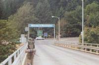
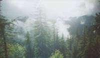
Today was cool and cloudy, which was good since we spent the whole day climbing. Cascade Locks is in the Columbia River Gorge, only 170’ above sea level. We had to climb to 3400’ in the first 12 miles, then we’ll go up and down and end up back at 900’ tomorrow, then work our way back up to 5000’. It’s a rather strenuous section. The roadwalk alternate route avoids about 7000 feet of climbing, and about 20 miles, but the trail starts off quite nice. It was very green, with lots of ferns and mossy trees and rocks. There were even some maples, just starting to change color. We passed one pretty green lake and a couple of streams. The views were scarce, but nice when we got them. The Columbia River Gorge was beautiful, though the walk across the Bridge of the Gods was rather unsettling since there was no pedestrian lane on the narrow bridge and there was a lot of traffic crossing the river. I imagine Lady Godiva was not happy, trying to lead or ride a horse across it. The cliffs above the river are quite dramatic.
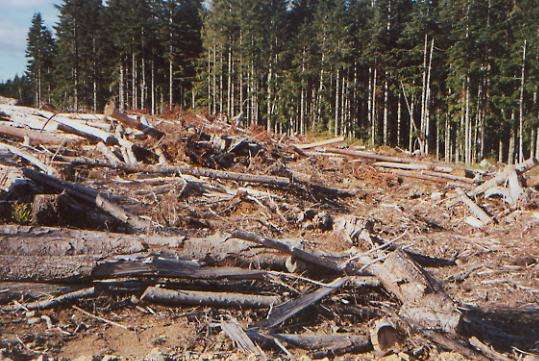
Our late start made for a late finish. We had to keep going long after we were ready to stop since there was no water for a 13-mile stretch. While there were a few nice views of Table Mountain, the Columbia River, and Mt. Hood, most of the day we just wound through the woods, up and down, round and round. It’s another connector section. We got rerouted through a huge clear-cut on a “temporary detour.” A lot of the hills around here have been clear-cut, mostly in the checkerboard sections. It’s very ugly, especially the freshly cut areas. Selective cutting is bad enough, but the clear-cuts are a devastation. In contrast, our campsite by the creek is among some very old trees—beautiful giants. There are signs of autumn, mostly red maple and huckleberry leaves. It may be a sign of drought rather than cold though. It was warm enough to wash up in the creek tonight — barely. Today we’ve seen some people on horseback, a backpacker heading south and a dayhiker, not many for being so close to town on a Saturday.

Sunday, August 27: FS 68 -- 19.9 miles (2191.0)
We had another cool cloudy day, winding through forest. There was a lot of climbing to start the day, but we had no views since it was so overcast. We met one southbound backpacker (WalkOn, attempting a yo-yo hike of the PCT) in the morning, but otherwise had the trail to ourselves. We had a very late start. Since we were at the bottom of a canyon, sunlight didn’t reach us until much later than usual. Besides, we were tired. It was a pointless sort of day, no views, no lakes, no berries, just up and down in the woods. It was pleasant, but we couldn’t help thinking that we were fools for doing the extra mileage.
We stopped at 4:30 to cook dinner at Panther Creek Campground, our last water for ten miles. We didn’t want to carry a lot of water as we began the next climb since neither of us had much energy, and it was nice to have pumped water and a picnic table. There were a few people camped there, but not that many. There were a lot of reserved signs for next weekend (Labor Day.)
At the campground we rejoined the alternate route. After a rest and dinner, it wasn’t as hard to do a few more miles, even though it was a 1900’ climb to the next campsite. As we were climbing, we met a couple of southbounders who were doing the Washington section of the PCT. Later on, we met a retired logger who was out for an evening stroll. We asked about campsites. He said he had worked the area 20 years before, but couldn’t tell us whether there was any camping ahead since he hadn’t walked that way recently. We finally found a small spot next to a dirt road. Not ideal, but it will do. I usually enjoy walking in the evening shadows, except when we’re desperately searching for a campsite. The chances of seeing wildlife are usually better at sunset, and we haven’t seen much lately. A few deer tracks and some bear scat lets us know they’re out there, though.
Monday, August 28: Deer Lake -- 21.6 miles (2212.6)
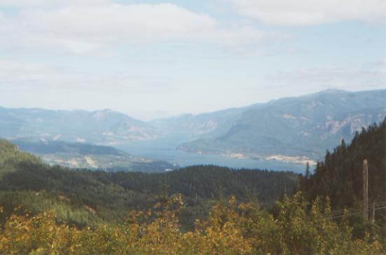
It was a pleasant morning ramble in the woods, despite starting with a 2000’ climb. There were a few views south to Mt. Hood and northeast to Mt. Adams. The blueberries were tasty and abundant. We skirted an old lava flow for a few miles.
Best part of the morning was meeting Namie Bacille (aka LET IT BE), a perennial long distance hiker who has done each of the long trails three times (a triple Triple Crown!) He was headed south to Castella. Namie recognized us from the CDT video we were interviewed for last year. Evidently we did all right; he was willing to talk to us. We had heard of him, but never met him. We sat down and talked to him for about an hour, then reluctantly moved on.
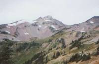
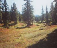
During the afternoon we climbed some more to a nice view of snow-covered Mt. Adams and another westward view of Mt. St. Helens. We passed several ponds and lakes. A couple — Blue and Bear Lakes — were large and clear. We ended up camped at Deer Lake, smaller and quite shallow, but with no other campers. We saw several people camped at the other lakes. We considered moving on after dinner, but decided to just relax and enjoy our lakeside solitude. It is very peaceful and pretty with the trees reflected in the still water.
Tuesday, August 29: Spring by White Salmon River -- 24.1 miles (2236.7)
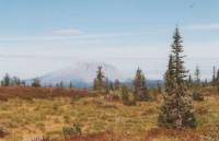
It turned into a grey day, though so far it hasn’t rained. The morning hike was very easy, though the afternoon had some stiff climbs as we approached Mt. Adams. A couple of the climbs reminded us of some of the Pennsylvania trails we know. Steep and steeper! Most of the day was in the woods with few views. Mt. Adams and briefly glimpsed Mt. Rainier were both covered with clouds. We had a good view of Mt. St. Helens over the russet colored huckleberry fields. We ate a lot of berries, though not at the fields that were reserved by treaty for the Indians. This area is known as the Indian Heaven Wilderness – lots of berries, lakes and wildlife, sounds like heaven. There were plenty of huckleberries before and after the reserved area. We met one speedy thruhiker, Jeff, who raced past us with hardly a hello, and then we spoke for a few minutes to a woman who works at Olympic National Park and is out for a week or so. A couple of dayhikers stopped to say hello on their way down Mt. Adams. We were able to find the off-trail spring where we planned to camp by listening for it. It is a gusher! We’re both sore and tired today. It was early when we stopped (5:30) but we didn’t really want or need to keep going, so we didn’t. Because of the clouds it feels much later than it really is. Clouds came and went all day, but now seem to have settled in for the night. It figures — tomorrow is supposed to have good views.
Wed., August 30: Midway Creek -- 20.9 miles (2257.6)
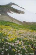
It only sprinkled for a short while last night as we were finishing dinner, then again an hour or so later. It was just enough to wet the tent and the bushes along the trail. Our feet and legs got soaked as we walked through the many meadows around Mt. Adams. It was clear when we woke up, but the clouds soon moved back in. So much for views of Mt. Rainier! We did get occasional glimpses of the glaciers above us, though none of the mountain as a whole. Still, it was pretty walking, fairly easy with short steep ups and downs as we wound around the ridges. I was surprised to see the same kinds of flowers up here that we saw in the desert: lupine, paintbrush, mariposa lilies and purple daisies. We tried to dry the tent at lunch, but the sun didn’t cooperate. Later the clouds lifted and we got views of blue-green mountains to the west of us.
Jim and I have been in hungry hiker mode lately, constantly starving. However we found a solution: huckleberries. We ran into acres of ripe berries, lining the trail. The bushes are turning red, but the fruit is prime. We spent a couple of hours munching on berries, one handful at a time as we walked. That slowed us down, but was fun (and filling.) We ended up stopping early again. We wanted to dry the tent and air out our damp sleeping bags, and besides, a bath was definitely overdue. The water was almost as cold as last night’s spring, but it hurt good! There was another spring today that was interesting. It came out of a huge lava flow. The rocks were piled up 20-30 feet high, looking as if a bulldozer had pushed them together. Lava Spring had good water too. We crossed a couple of lava areas today. Mt. Adams is still considered active, although the last eruption was 1000 years ago. We saw lots of people, as usual, mostly day hikers out gathering huckleberries. Mid-afternoon we ran into someone we knew, Yoyo, who hiked the AT in 1998. We sat and talked to him for about an hour. He was out for just a few days.
Thursday, August 31: Lutz Lake -- 27.9 miles (2285.5)
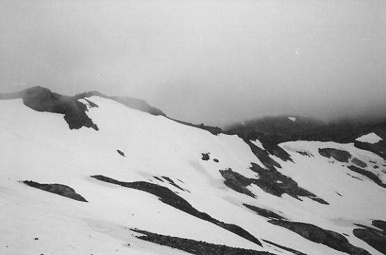
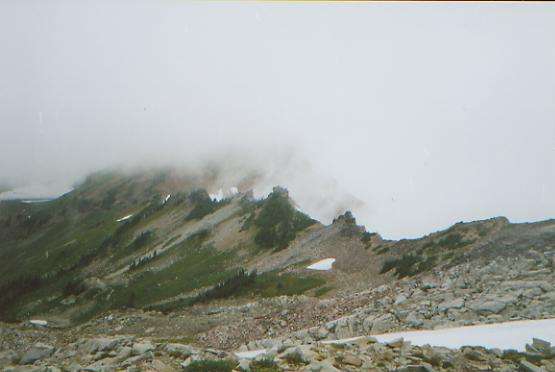
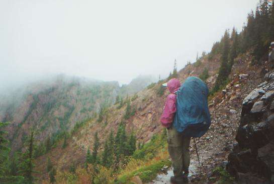
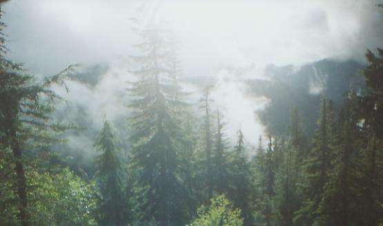
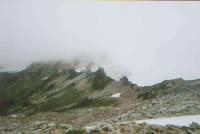
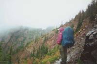
We woke to dense fog shrouding the forest. It didn’t really matter since the morning hike was mostly a woods walk past ten small ponds. It was cold and damp, but not really wet. Occasionally the clouds would part, allowing us to glimpse a flash of blue sky or even sunlight, but then the clouds returned. That was yesterday’s pattern too, until the clouds finally broke up mid-afternoon, so there’s hope for us yet. We’re hiking through the Goat Rocks Wilderness, one of the more scenic parts of Washington, and I would really like to see it. We get glimpses of autumn-colored ridges ahead, and had one glimpse of Walupt Lake below us, but mostly this has been another day of just wandering through the woods. I had high hopes for Washington, but so far, aside from steeper, more frequent climbs, it has been just like Oregon: lots of trees with only occasional views of far-away peaks. We will go up to an alpine environment this afternoon, so I really hope the weather clears--for safety’s sake, as well as for aesthetic reasons. So far we’ve only had one brief shower, despite three days of clouds, but I know that can change quickly.
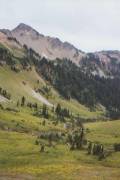
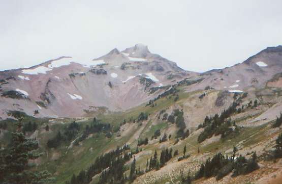
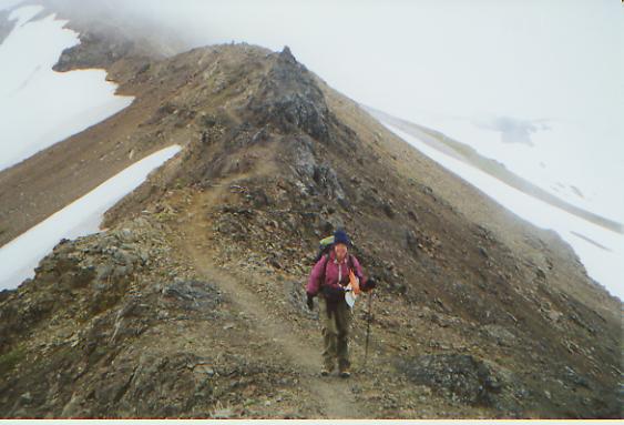
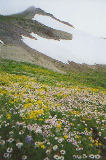
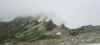
Later: It was a long and difficult day, but often a fun one, despite, or perhaps because of, the difficulty. We started the day with mist rising from the ponds, and ended with clouds pouring over the mountains, rising from the glacial bowls below us. It seemed as if they were giant cauldrons, brewing up clouds. In between, there was much beauty. All afternoon, we were out in the open, either on open slopes, walking through flowery meadows, or up above treeline. The clouds came and went all day. For a while, cloudline was about 500 feet above us, so we could look out, but not up. Occasionally the clouds would part so we could see beautiful ridges and glacial valleys. We climbed over the highest point on the PCT in Washington, then crossed the top of a glacier. We had crossed a few good-sized snowfields earlier, but the north side is all glaciers. Until then, we had been really enjoying the day — the beauty, the clouds, the abundant wildflowers, etc. It reminded me a lot of Colorado, especially around Cispus Pass, which was very much like San Luis Pass on the CDT. It was really beautiful.
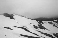
Unfortunately, we went too far. We had wanted to cross the snow late in the day, when it would be soft. We gambled that the clouds would clear. They didn’t. The far side of the high point was total white out. We followed footsteps across the glacier and up to the rocks on the far side, unable to believe that the extremely bad path across the talus was actually the trail. Then we met another couple coming up, and learned that yes, that narrow rocky path was really the PCT. We followed a narrow ridge for a mile or two, with 30-40 mph winds trying to knock us off the edge. It was cold! There were occasional views through the clouds of the snowfields around us and the cirques below us. We decided to push on to treeline, where we would be protected from the weather. Unfortunately, that meant a very long day. Parts of the trail were very rough, steep and rocky, but the last mile or so was great.
We finally ended up near a small pond. There were some people camped nearby, but we didn’t disturb them. We arrived at 7:45 and it was dark at 8:00. It started to rain soon after and rained off and on all night, though never very hard. The whole day was a gamble: that we could get over the passes before the weather turned really bad; that the weather wouldn’t clear up completely overnight, making it smarter to wait in order to get some views; and that we would be able to find a good campsite before dark. We won, sort of.
Friday, Sept. 1: White Pass -- 12.5 + .75 (2298.0)
It was raining when we woke up, so we rolled over and went back to sleep. It cleared up off and on, then big black clouds moved in. The first few miles were down in the trees, but then we climbed up Hogback Ridge, with beautiful views back toward Goat Rocks and down to Shoe Lake. I don’t know whether we would have done better to wait yesterday or not. We still can’t see Mt. Rainier, and Old Snowy is still mantled with cloud. It is noticeably colder and I really don’t like the look of the clouds to the south. Parts of the trail this morning were completely dry, but some backpackers we met said they got snowed on last night at Shoe Lake.
After a short lunch at a windy pass looking back at snow-covered Goat Rocks, we descended to White Pass, a ski area with a small gas station mini-mart where we had our next maildrop. At the store, we met Chad, Sly and Cheryl. Sly and Cheryl had taken a couple of days to visit friends, which is how we caught up with them again. It started to pour, so we decided to get a room at the motel next door with Sly and Cheryl. We did laundry at the store, and took a wonderful hot shower, then drove about 30 miles to a restaurant for dinner. White Pass is limited in that regard. There are a few hot foods at the mini-mart, but not much. We met Alan Douglas at the restaurant. We had met him in Cascade Locks. His wife came out to meet him for the weekend. Chad’s wife did the same thing. We’re not far from Seattle, I gather.
Saturday, September 2: Two Lakes -- 20.5 +.75 (2318.5)
We woke to grey skies, but no rain. We got some coffee and muffins at the little store for breakfast and met a couple more thruhikers, Angela and Duffy. They came over Goat Rocks the day after we did, and said the weather was much worse — wet and cold. I had corresponded with Angela before the trail, briefly. The PCT really is a small world. Sly is going to hike with us for a while, I think. He’s a good trail companion.
It’s Labor Day weekend so there are lots of people and horses out here. Several were leaving as we entered the wilderness, probably unprepared for the weather. There are a lot of lakes in the William O. Douglas Wilderness, so it is popular. Final total: 27 people, 9 horses and one dog.
The walking has been really nice, despite the cold and grey skies. We had rain and sunshine alternating all afternoon, with serious rain only after we set up camp. The long climb felt really good. It was one of those days when I really remembered why I love to hike. We got into the rhythm and just hiked up and up, smoothly and easily. There were few views, except of rocks above us, a few lakes below, and clouds all around. Still no Rainier. Every time the guidebook says we’ll get a good view of Mount Rainier, it rains or is completely overcast. The curse of the mountain? We saw one deer, one tiny frog and one dead (and very smelly) mountain goat. I think the ridge top is probably quite beautiful, in good weather. Maybe tomorrow will be better.
Jim’s foot is giving him a lot of trouble. He seems to have developed a Morton’s Neuroma (a pinched nerve on the bottom of his left foot.) Between that, blisters, and the broken toe on his right foot, he has been in pain for most of the trip. As usual, as I was happily climbing, he was feeling miserable. We have a hard time getting it together sometimes. Maybe that’s best. On my bad days, he cheers me up, and on his bad days, I can share a smile and a hug. The camera broke this afternoon. Kind of a frustrating day. I enjoyed it though. I always enjoy starting a new section. There is a feeling of endless possibilities. Each section is unique, one way or another.
Sunday, Sept. 3: Martinson Gap -- 22.6 miles (2341.1)
We woke to blue skies and sunshine, but by 10:00 the clouds were back and by noon it was raining and hailing on us. It rained and sleeted off and on all day, with only occasional moments of sunshine. The views were spectacular, when we had them. We finally got a glimpse of Mt. Rainier this morning, wreathed in clouds. We walked on or near ridgeline for a large part of the afternoon. There were several nice lakes and views down to them. The clouds created their own beauty, especially the big black menacing thunderheads to the south. We saw one elk and four deer. It was interesting walking, but we ended up pushing until almost dark because we couldn’t find a campsite. Our first choice was occupied, another was soaked and not very flat, the next we missed somehow, and then we had miles of sidehill trail, with no flat spots. Finally we passed through a flat gap and found a place to set up. It rained again soon after. The night was very cold, especially in our damp tent and sleeping bags.
We met up with Cheryl briefly at Chinook Pass in Mt. Rainier National Park. There were a lot of dayhikers there, despite the rain. Sly picked up some food for the next few days. Having Cheryl’s support means he can carry a much lighter pack. Since our current partnership is pretty loose, we haven’t really taken advantage of her frequent visits to the trail to lighten our loads. We never talked about it, we just hike together. If Sly decides he wants to go faster or slower on any day, we’ll separate, then meet up again farther up the trail. It’s not really a partnership, we’re just travelling companions. He’s good company, very laid back and easy to get along with. It’s odd, we’ve met so many other thruhikers out here—at least 50 or 60—but the only hikers we’ve hiked with for any extended period of time were people we knew before we came out here. Of course, a lot of the early hikers we met are off the trail: Doug and Christa, John, Emily, Pete, Garey, Ryan, Jonathan, Marc, Kathy, Brad, etc. Most of the others we passed, we don’t know where they are. Occasionally we’ll ask one of the fast hikers, and they’ll tell us that Sundance and Drew are still on the trail and some of the others. As for the ones that passed us, we rarely saw any of them again. Steve is the only one we really played leapfrog with. We know how far ahead some of them are from the occasional registers in Post Offices, but that’s the only contact we have with them once they pass. A lot of hikers were either faster or in more of a hurry than we are. Oh well. There isn’t as much of a sense of community out here as on the AT. I miss it sometimes. Without the shelters to concentrate the hikers, we can be hiking within a few miles of another thruhiker for days, and not see him/her until we get to town, and often not even then.
Monday, September 4: Beyond Blowout Mountain -- 22.1 miles (2363.2)
We woke to blue skies, ice in the tent, and frost on the ground. The sun on the frozen ground created a dense fog, so we couldn’t see much except the great white sheet. Lunch was at the Ulrich Shelter in Government Meadows. It was a really nice cabin that would be a good place to stay, though we just used it to dry out the tent a bit since we were so early. It’s too close to a road though. There were some people there when we arrived: a family out bow-hunting and two men hunting mushrooms. The only others we saw were two day hikers munching berries and two backpackers at the end of the day, looking for a campsite in an area with no water. We all ended up stealth camping in the forest. We went too far again, passing a nice site, then finding nothing for the next two miles. It started to rain, so we finally cleared a couple of spots on a small hill above the trail. It’s a bit lumpy, but it will do. We have carried water from a small spring seven miles back. An old fire zone provided a bit of excitement in the form of downed trees that were quite a chore to go over and under and around. We got a few nice views in the afternoon, but mostly we just had views of clear-cuts. We will go though a lot of them over the next few days. A big thunderstorm to the south provided some visual excitement and our first rainbow on the PCT.
Tuesday, September 5: Cle Elum -- 15.2 miles (2378.4)
Another cold grey day. This is getting depressing. The fog was so thick we could see nothing. The hike was through alternating clear-cuts and dense forest. The contrast is interesting, but it is still sad to see the huge stumps where trees used to be. There were lots of fat berries in the clear-cuts, but are they ugly!
Jim has some sort of stomach upset with diarrhea. About 3:00 Cheryl came to meet us near Stampede Pass. She said she had a room in a nearby (30 miles or so) town, were we interested? We looked at the drizzle falling around us, thought about setting up and cooking dinner in the rain again, and answered “yes!” So we ended up in town a day early. We have our own room this time, as the motel is not very expensive. Cle Elum is next to the town of Roslyn, where they filmed Northern Exposure a few years ago. We stopped by to see the Brick and the Café, looking much as they did in the TV series.
A hot shower eased a lot of the pain. Even when it wasn’t raining, everything was damp and chilly. Between that, the grey skies and clouds that blocked all hope of a view, and the devastated forest, we were not very enthusiastic about the trail today. Last year we didn’t want the trek to end. This year, I think we’ll be ready.
Wednesday, September 6: Cle Elum/Snoqualamie -- 18.2 miles (2396.6)
Cheryl drove us back to the trail after breakfast. It was drizzly, but not really raining for the most part. Everything was soaked though. We got drenched just walking through the overgrown brush along the trail. We hiked packless, but it wasn’t as fast and easy as we had hoped. Parts of the trail were pretty rough, rocky, wet, overgrown, and steep, so although we pushed as hard as we could, the hike took longer than expected. I hate pushing for speed. It makes the end more important than the journey. Not that the journey was very exciting. There were more clear-cuts and lots of clouds, I-90 far below and a couple of small lakes. One, Mirror Lake, was a beautiful sapphire color. The others were just mucky ponds. We saw Alan and a fisherman carrying a blown-up U-Boat on his back and a couple of dayhikers collecting blueberries, but the weather and terrain kept most people home. We reached the ski resort at Snoqualamie around 5:00, picked up some of our mail at the small store, said hello to Weathercarrot at the motel, went to Roslyn for pizza, then happily returned to our room to shower and rest. We’re tired.
Both Jim and I got really depressed today. When Alan told us that, according to someone at the NOAA Weather Station near the trail, the forecast is for at least ten more days of rain, we both wondered whether it was worth continuing a hike in which we see nothing but clouds, and where we push so hard for so little reward. If we weren’t so close to the end, I’m not sure what we would do. With only 14 hiking days left, I know we’ll continue, but I’m not sure how much fun it will be, dealing with grey skies, constant drizzle, wet gear and no views. Why are we out here again? It’s not the best way to end our trek, but it’s probably appropriate. Much of this journey has been more about endurance than enjoyment. We knew Washington could be wet, but we hoped for a dry September. Some years, September is great for hiking. Just not this year.
Thursday, September 7: Day off in Cle Elum
Home | Links| Trail Journals |
The Thruhiking Papers | Bun-bunSouthern California | Central California
Northern California | Oregon | Washington
Created: 16 Jan 2004
Revised: 30 Sept 2016Copyright © 2000-2017 Spirit Eagle