|
|
|
 |
 |
 |
 |
|
|
|
|
|
|
|
|
The Pacific Crest Trail
Wrightwood to Mojave
Sunday, May 14: Rest day in Wrightwood
We took it easy, just eating, reading the Sunday paper and talking. As the day wore on, more and more hikers drifted into town. We saw Emily, Sundance, Brad, Marc, Ryan, Jonathan and two southbound hikers — John and Sandy. They started northbound, flip-flopped to Walker Pass and are hiking south for a while, then they’ll head north again when they finish Southern California. We all gathered for pizza in the evening at the karaoke bar. (We ate outside, away from the 'music'.) John told us in great detail about trail conditions ahead. Dave went home about 4:00. Brick came up from San Diego and spent the afternoon with us, talking trail and showing how to make a super-light alcohol stove out of Pepsi cans. It was a good restful day. It was really nice to see Dave and Brick.
Monday, May 15: Little Jimmy Campground — 14 miles (385.9)
While waiting for the Post Office to open, we ran into an old AT acquaintance, White Buffalo (aka Jean), whom we met in 1992. She lives in Wrightwood now. She offered to take us back to the trail after we finished sorting and repacking our drift box. It turns out we could have gotten our box on Saturday after all. The postmistress hands out mail on Saturday morning, even though the window isn’t open. Oh well, if we’d known, we still would have stayed, probably.
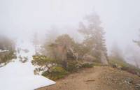
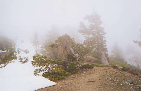
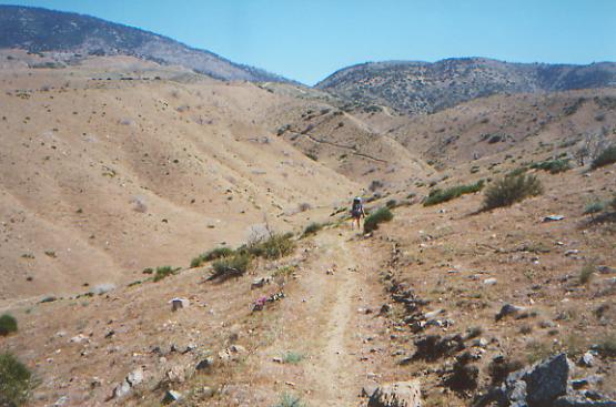
The day started out fine, but as we were eating lunch about three miles up Mt. Baden-Powell, low clouds moved in and decided to stay for the rest of the day. It was also very windy, a cold wind that smelled like rain and blew the clouds in all directions. About that point, the snow on the ground became more frequent and the trail more obscure. We lost the treadway, but since we knew it switchbacked to the top, all we had to do was find a safe route up the ridge. Not so easy. The PCT doesn’t go quite to the top, though there is a side trail that climbs the last 100 feet or so. We had intended to climb to the summit, but the wind was so fierce we decided it wasn’t safe. The trail followed along or near the ridge for several miles. When it was on the right side, there was lots of snow on the ground, but no wind; when on the left, there was no snow, but an icy wind buffeted us. I’m not sure which was worse. Jim and I were ahead of the group, so we had to make our own footsteps in the snow. Not all that easy. It spit rain at us occasionally, but not much. There were no views to make up for the exertion, except for a few glimpses of gray hills under the clouds.
The spring and campground at Little Jimmy were very welcome sights, tucked out of the wind and without much snow. We were very cold and tired by the time we reached them. We were soon joined by Jonathan, Ryan, Brad, Sundance and Marc. There are a lot of backcountry campgrounds in the San Gabriels with picnic tables, outhouses and fire rings. Nice. In the summer, they are probably pretty crowded. So far, we have had them to ourselves.
Tuesday, May 16: Sulphur Creek Campground — 21 miles (406.9)
We woke to the slithery sound of sleet on the tent. Quickly, we pulled our packs under the vestibule and went back to sleep. We were reluctant to get up in the morning, but eventually we emerged to a campsite covered by about half an inch of fresh ice and snow. Packing up took forever as we kept wandering over to Ryan’s fire to visit and warm up, then back to our wet gear. It wasn’t snowing, though there was fresh snow underfoot and clouds came and went all day. Sometimes we were walking in the clouds, sometimes in cool sunshine. The snow was mostly melted by noon.
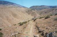
Much of the morning was spent following some creeks in Cooper Canyon. The creeks we followed would have been good for bathing, if the temperature had been above freezing. I didn’t expect to be in the pines this long. At the moment, desert heat sounds appealing, but it is nice to still be in the mountains. We avoided one big climb over cloud-covered Mt. Williamson by walking through a tunnel on the highway, as recommended by John and Sandy. There were no cars on the road, (thanks to the heavy fog) which was nice since we ended up following it for about a mile. There just seemed to be no point in doing a steep long climb with no views, when an easy alternate route existed. There were a lot of fallen rocks in the road; we moved some of them out of the travel lanes. We crossed the highway several times. Some of the others just skipped the trail entirely and stayed on the road all day. The endless winding gets to us all, from time to time.
We had lunch at a campground, where we watched some Forest Service people sifting dirt. I finally went over to ask what they were doing, and was told that they were doing an archaeological dig prior to moving the outhouse as there are signs of Indian artifacts in the area (stone points and obsidian, mostly.)
We then moved on, up and down on new trail, back and forth across the highway. They had done a relocation there that we didn’t know about. It added a mile or more, and a lot of climbing. It hailed, rained and snowed on us. Finally the sun came out. We never got really wet, but it was chilly. More winding through manzanita and oak brought us to an equestrian campsite just off the trail. It’s sunny and has a creek nearby, so we stopped instead of moving on ¼ mile to the regular campground. Marc stopped here with us. Jonathan missed the turn and passed us, so Ryan went after him. I don’t know what happened to Brad and Sundance.
It’s very windy and cold. I tried the Pepsi can alcohol stove that Brick gave us, but with this much wind, it wasn’t very efficient, so I switched back to the Whisperlight. The alcohol stove just wouldn’t boil the pasta. I had to refill it three times. A lot of hikers love them though. They’re light and cheap, but time consuming if you’re cooking for two. I guess I’m a bit hidebound. I like my Whisperlight--it has worked well for me for many years—so I’m reluctant to change. Kind of along the lines of “if it ain’t broke . . . ” How far am I willing to go to save weight?
Wednesday, May 17: Messenger Flats — 24.1 (431.0)
We did 13 miles this morning, climbing easily in pine forest, then dropping down to the ranger station at a trailhead which has a real bathroom and good water. The hills were pretty-- covered with pines--and the trail was easy. We spent lunch drying out our gear again. There was a heavy dew/frost that soaked us last night, then froze. The sun came out this morning, but the breeze was still cool.
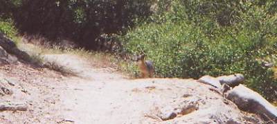
Later: The afternoon was more of the same. It got warmer, especially on the sides of the hills that are covered with chaparral instead of trees. The big excitement was seeing a kit fox on the trail about 15’ away. He was wary, but not afraid. Usually you barely glimpse them. This one let us take its picture before he ran off.
Later we were passed by a man leading a laden packhorse — Len and Pancho. They left Campo April 28 and plan to go as far as Kennedy Meadows, just before the Sierras. They stopped at the campsite we had planned to use, near a tiny creek, but since it was at the bottom of a ravine, I was just as happy to pass it by. I like sitting in the sun at the end of the day. We moved on to a Forest Service campground, where we caught up to Doug and Christa, Emily, John Meyer, and the dogs. They’re moving slowly right now because Monty, the black chow/lab, has a problem with one foot. They were a full day ahead of us. Ryan and Jon ate dinner there and kept going. Marc hasn’t appeared yet, but he will. We really didn’t expect to meet up with them, but it is nice to have company again. One funny incident: Jim and I had gone up to the outhouse. When we returned, Monty wouldn’t let us go to our tent. Evidently he decided he was supposed to protect it, along with Doug and Christa’s gear. Doug called him off, but we weren’t sure whether to laugh or get mad. Evidently Chows can be very protective. The German Shepherd is very shy and unaggressive, in contrast. She and Monty get along surprisingly well – to the point that at least once she ran off and followed him instead of staying with John.
Thursday, May 18: Ridge between Soledad and Aqua Dulce Canyons — 16.6 + .6 (449.6)

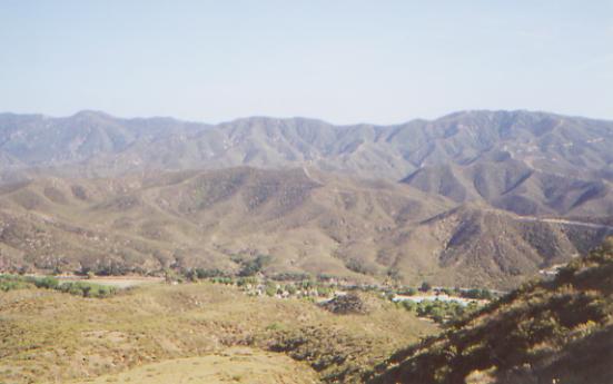
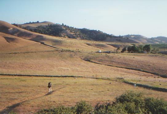
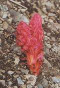
We’re taking it easy as we descend back to the desert. We stopped at a ranger station for water, then continued winding down through the chaparral. Flowers provided a little interest. We can see the trail ahead, a scar across the landscape. They built it wide through here, and its path is visible for miles. We’re debating whether to do a long day or a short one today. We’re heading for Agua Dulce, our next resupply town, tomorrow. Do we want to arrive in the morning or the afternoon? Does it matter? There’s a campground where we could stay tonight, but it would make tomorrow longer. Sore feet and ankles cry for rest. We were both hurting last night and were too tired to be very sociable.
Later: We took a long two-hour break at the RV campground, then went on another four miles or so to a ridge high above the canyons. The views are nice looking south, back toward the area we hiked today. Ahead is a freeway across the Antelope Valley and some houses. It was very hot down in the Soledad Valley, so a long rest in the shade was welcome. As we descended, the swimming pools below looked so inviting. I took a quick shower and drank a diet Pepsi, since that was all that remained in the coke machine. Jim was very disappointed, as he was really looking forward to a cold Coke. Still, it was cold and wet. Doug, Christa, Emily and John ordered pizza from a place in Agua Dulce. Jim and I planned to move on, so didn’t join the order, but when we couldn’t get up the energy to move, we looked on enviously as they ate and gratefully accepted one slice. They were talking about staying at the RV park. It only costs $5 to stay there, with shower and laundry facilities. Since we plan to stay at Agua Dulce tomorrow, and will do both there, stopping tonight wasn’t as appealing. Breakfast in town tempted us more.
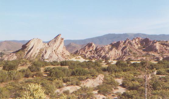
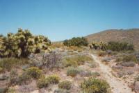
The benefits of my shower were quickly lost as we began the climb past Vasquez Rocks in the late afternoon heat. They’re big round domes, made out of conglomerate rocks. Some caves looked interesting. I wonder if they hold any mountain lions? There are scattered desert flowers. Yellow and orange poppies and white morning glories are a nice change from the usual paintbrush and lupine. It feels odd to be back in the desert heat after the cold of the past few days. Our bodies have forgotten how to deal with it. For the next two weeks it will become very familiar as we skirt the Mojave Desert. I like being able to sit out in the evening and not be cold. I love sleeping under the stars without the tent walls closing us in. I like the constant chorus of birds. We’ll see how I deal with the heat, dryness and the long long waterless stretches.
Friday, May 19: Agua Dulce — 5 miles (454.9)

We had a restless night atop our ridge, fighting mosquitos, listening to the trucks on the freeway, and watching the full moon float across the sky. It was a relief to get started down the canyon toward Agua Dulce. We had a really interesting stretch wandering through Vasquez Rocks State Park. The formations, a mix of sedimentary and conglomerate rocks, were really interesting. It looked like New Mexico, with red and white tones and juniper and pinion trees scattered about. The trail was somewhat obscure though. Several hikers got lost in the park.
We reached town at 9:00 and were disappointed to discover the café there doesn’t serve breakfast, so we went to the grocery and bought some eggs and bread for breakfast, as well as supplies for the next week. Agua Dulce is a pretty area, with nice houses, many with horses and dogs. Town is very small though, a lot like Warner Springs. The Post Office was funny: they just put all our packages helter skelter on one of the shelves of the grocery. There was no record of the packages received, and they were in no order at all, so we had to look through every package to make sure we hadn’t missed anything. The hikers’ letters were just placed willy nilly in a box. Not your usual post office! They were very nice though, just not organized.
Then Donna Sauffley, a local trail angel, came to pick us up. She and her husband live about a mile and a half out of town, and have a trailer annex just for PCT hikers. They are really incredible people — very generous. The trailer has a kitchen, a living room with stereo, TV and computer, a couple of bedrooms and a nice garden. She is even doing our laundry (yech!) One really nice touch was that they had clean shorts and t-shirts to change into while she does the wash, so we can hang out in comfort. Since so many hikers carry minimal clothes, she said it was better than having half naked people waiting impatiently for their clothes.
So we are now clean, rested and ready for dinner. It will be a full house tonight. When we arrived, we saw Drew and John, who plan to leave tonight and do a night hike, Doug, Christa, Emily, Marc, Ryan and Jonathan. Later six more hikers arrived: Sundance, Brad, Kathy (aka Sunshine), Ed, Mule and Dave. The Sauffleys have a lovely property here, with flowers, fruit trees, a view of the mountains, and six dogs to keep life interesting.
It was a fun evening. Jim and I ended up ordering pizza and salad from town, then couldn’t finish them. We shared with the group that shared with us yesterday. HairBear (Marc) and Drew went to the city to buy material to sew kilts for themselves. I can see the value of a loose skirt, but I would think wool would be too hot in the California heat. Brad and John exchanged haircuts, sort of. Brad ended up with a Mohawk, and John ended up with a clean-shaven face, but with his longish hair intact. Everyone watched the proceedings. We’re so easily amused. Marc is a professional musician, so he played the Sauffley’s guitar for a while. It was nice to have real music. That’s one thing I really miss on the long hikes.
Saturday, May 20: Green Valley Ranger Station — 22.7 + 1 or 2 miles (477.6)
We had a late night, listening to all the conversations around us. On the trail we all go to bed with the sun; in town, electricity keeps us awake a lot longer. The more people, the later we stay up. Still, we managed to get an early start. Christa made pancakes for breakfast and we got on the trail about 7:00 a.m.
Jim and I walked through town, then up into the hills beyond. The heat was intense, though there was an occasional breeze to make it bearable. While watching a quail trot up the trail, I noticed a coyote on the switchback above us. He ran off fairly quickly, but it was fun to see a coyote after only hearing them for so long. Soon after, a quartet of motorcycles appeared. We confronted them and made them turn around, since they were on the trail illegally. “What, do you think this is your trail?” one of them asked. "Yes," I answered quickly. "It is my trail."
Donna left a water cache near a road about 10 miles out of town, so we stopped for lunch in the shade of an oak tree with Marc, Ryan and Jonathan. We left too soon, not waiting for the heat to ease, and paid the price. We were slow and halted at every hint of shade. The trail was longer than expected, or at least it felt that way. We weren’t that slow! There had been a relocation, which didn’t help.
We got water from some people at the Messenger Flats Ranger Station and set up camp nearby just as it was getting dark. It wasn’t a great site, being too near a road and under high tension wires that buzzed, but we were so tired we didn’t care. The others got a ride to a nearby restaurant, then took off to hike by the light of the full moon. We considered doing that, but after 23 miles, we were just too tired to keep going.
Sunday, May 21: Bear Campground — 24.9 (502.5)
We woke up at 5:00 and got an early start. It was nice hiking for the first couple of hours, but by 9:00 the heat was oppressive. We stopped in the shade of a sycamore grove, where we met Jon, Ryan and Marc, and were surprised by a group of trail runners doing their Sunday morning run. It turned out the water cache in the trees wasn’t intended for PCT hikers, but belonged to the runners. Oh well. We hadn’t taken any, since there was supposed to be a good spring a mile or so away, which was just as well. We climbed and wound around the hills on badly eroded trail heading for a campground in the trees where we stopped for a long overdue lunch. The plan was to rest all afternoon at Shake Campground and hike on in the evening when it was cooler.
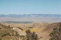
The morning was very mixed, emotionally. There was more shade than yesterday—oaks and a pine plantation—and occasional views off the ridge toward the desert and mountains north of here. I got frustrated at the winding and the eroded trail, and very mad at the motorbikes that contribute to the erosion. At the same time, I was moving well, happy to do 15 miles before noon, and not quite as bored as I was yesterday. When we got to Shake Campground, we couldn’t find water at first. I was ready to quit the trail right then. Marc finally found some water in the creek about ¼ mile downstream. So much of this hike has been endless twisting and turning in dense chaparral, with views only of green chaparral-covered hills in all directions. The distant reservoirs, when glimpsed briefly, are pretty, but too far away. The blue waters tease us. The land is pretty, but really repetitious as we wind in and out of each and every gully. When we parallel dirt roads, taking twice the mileage to do the same distance, I really get fed up. Jim is in a lot of pain from his feet, so he is slow and quiet. I remind myself that the heat and chaparral are temporary, but it doesn’t make it much easier. The Sierras seem a long way away. We’re pushing hard because of the lack of water. It’s another 23 miles from here to the next water source. That’s ridiculous. It forces us to do very long days, just when it’s so hot the smart thing would be to hole up in the heat of the day. Some people get into night hiking, but that has its hazards, like snakes you don’t see until you step on them. My night vision isn’t good, so we haven’t done any night hikes yet.
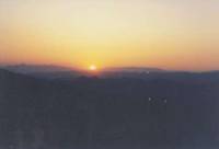
After a long siesta, we hiked another 10 miles, starting at 5:00. The last three miles were on a dirt road, as I didn’t want to hike the rough overgrown trail in the dark. There was a beautiful sunset as we walked, and we ended up setting up camp in the dark at a small dry campground. There were a couple of section hikers camped nearby. The afternoon walk was mostly nice, through oak groves and Coulter pines. Only the last few miles were in chaparral. After sitting out the heat all afternoon, it was a bit ironic that most of the afternoon’s hike was shaded. We could have kept going after all.
Monday, May 22: Aqueduct — 26 miles (528.5)
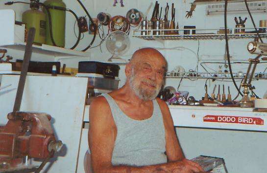
We woke up with the sun and headed down the trail early. In the lower elevations, as we wound up and down over the hills of the Tejon Ranch, it was already hot by 9:00. Two trail angels helped us out. One left a water cache, so we drank a pint apiece and moved on. A mile farther, we ran into a small cooler with some sodas, put out by a man who runs the Three Points Roadhouse, a few miles off trail. He lets PCT hikers eat and stay there for free. I wish we could have gone there, but it was too early in the morning when we reached the road leading to the roadhouse. Instead, we kept going to Jack Fair’s house, on the edge of the Mojave Desert. He is a 76-year-old former hard-core biker (founder of the Shaggers) who gives hikers water and lets them sleep in the garage, take a shower, or get a ride to the near-by grocery, for a small fee. Jack is a real character. Not a nice man, but interesting. At one time, he trained ocelots, he told me. He liked Jim and me, though I heard he can be pretty rude when he wants to be. He looked at the group in the garage and said, “You hikers remind me of the worst of this country. So much waste!” I don’t know if he referred to the junk food we had picked up at the store, or the waste of our lives because we were hiking instead of doing something more productive with our time. Or maybe he meant something different entirely. With Jack, you can’t tell. He had signs with little sayings all over the walls of the house and garage. They almost made sense, but not quite.

We walked 14 miles to his house and then sat in the shade to wait out the afternoon heat. The next stretch crosses a finger of the Mojave, following aqueducts, before climbing back into the dry hills. Mid-afternoon the temperature was in the low hundreds outside, despite the wind. Our plan was to wait until it cooled off, then do an evening hike across the desert. I dread two more weeks of this heat. We wake up dry, walk dry, and only get really hydrated at the water sources. We end up pushing from water source to water source, 20 or more miles every day. It’s not that difficult, but it isn’t much fun either.
We saw a big fat diamondback rattlesnake in a bush this morning. Jim saw the tail end of a deer yesterday. I saw a coyote vanish in the brush this afternoon. There are compensations.
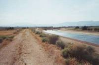
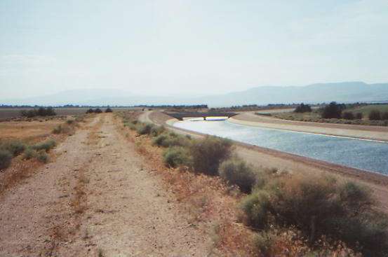
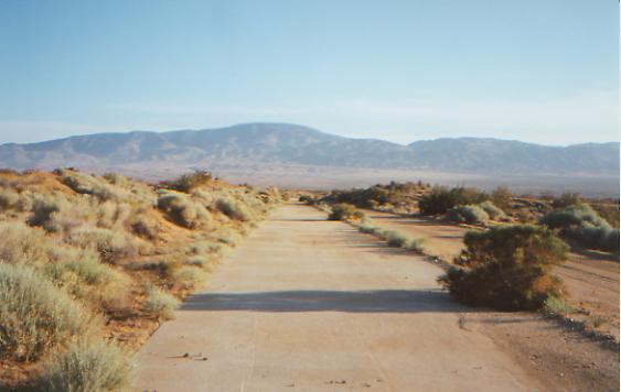
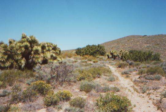
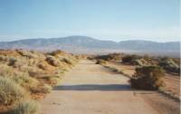
We left Jack Fair’s at 5:00, and followed two aqueducts across the desert. One was an open one, with blue sparkling waters that we followed for a couple of miles. The second was a buried pipe. For the next 15 miles we’ll follow the concrete-covered pipe on jeep roads. The desert here is different, with mostly low brush and occasional clumps of Joshua trees or creosote bushes, and lots of little flowers (ghost flower?) There are a lot of houses scattered in the desert. We walked 7 or 8 miles, then stopped to rest and cook dinner. After dinner we continued to walk in starlight until we got too tired to keep going. The moon didn’t rise until after we stopped for the night, but the concrete covered aqueduct was easy to follow in the dark. We just had to watch out for the occasional low wall across the path. It was fun watching blue and green shooting stars overhead. Jim said it was probably a satellite breaking up. He should know. There is a town nearby--pretty large, judging by its lights. A few cars passed, but mostly the road was pretty quiet. Eventually our sore feet forced us to stop in a dry sandy wash just off the dirt road. It was a nice hike, all in all. Different, anyway.
Tuesday, May 23: Oak Creek — 26.4 miles (554.9)
Despite our late night, we woke up before dawn and continued across the desert, climbing gradually toward the Tehachapi Mountains. We crossed some burned areas, but even the unburnt stretches were dry, with little vegetation. We got water at the spring/aqueduct at Cottonwood Creek (which only has one cottonwood tree, but lots of Joshua trees.) Six miles later we got more water at Tylerhorse Canyon, but it tasted like ashes from a bad fire upstream. The sides of the canyon and the water were grey and dusty. Lunch was eaten in the arid confines of Gamble Spring Canyon, under the very meager shade of a Joshua tree. It was a long hot climb out of there, on soft eroded trail, badly damaged by dirt bikes. They’ve really made a mess of the area, riding carelessly on fragile desert soil. We heard one rattlesnake last night, but didn’t see it. This morning only a few lizards kept us company. The guys never caught up with us last night. Jon, Ryan and Marc left Jack Fair’s right after we did, and Dave and Mule weren’t that far behind. Maybe they went for a swim in the aqueduct. Or they may have passed us while we slept. Jim and I are both tired from the long miles on short sleep. Climbing from 2000’ desert to 6000’ doesn’t help, though there is some hope that it will be cooler up higher. At least there will be trees. Tylerhorse Canyon had a lovely big pinion tree, but it was too early to stop for lunch when we passed through there.
Later: The climb out of Gamble Spring Canyon was exhausting. It was only three miles, but the trail was totally exposed without a bit of shade until we had climbed the first 700’. Then there were some nice pine and pinion groves. Where were they when we were looking for a cool place to eat lunch?
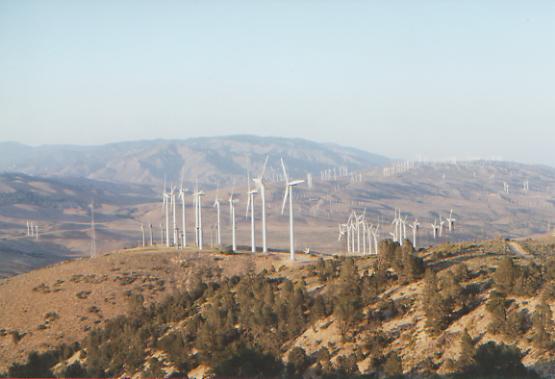
We barely made it to the water at Oak Creek before dark. I wanted to camp a few miles back, but Jim wanted to get closer to the creek. We were carrying enough water to dry camp, but by the time I convinced him to stop, there was no place to camp. We hiked way past exhaustion. We hurt all over. The whole area for about 10 miles is posted, “Do not leave the trail.” Given that the owners allow dirt bikes and ATV’s to totally destroy the land, it is hard to take that very seriously. It made me really angry and sad to see the destruction. There was a maze of sterile ruts everywhere. Later on we passed beside a big wind farm. We saw three rattlesnakes in the last couple of miles: one baby, one medium-sized, and one grandfather snake, big as my arm. They were three different varieties too.
Wednesday, May 24: Mojave — 8.6 miles (563.7)

We got an early start, as we were eager to get to town and get cleaned up. The morning hike was nice, over big rolling hills, covered with windmills. They are weird things, but interesting. We saw one yesterday that had fallen over. That’s a bit scary when you’re walking right under them. We passed a couple of ranches this morning, with cows and horses and grassy meadows. It reminded me of Wyoming. Then we dropped down to the freeway. It turns out the guidebook was right; that wasn’t an easy place to hitch a ride. We would have done better to go into town on the Tehachapi-Willow Springs Road, 8 miles earlier, but it makes the next section more difficult, so we kept going. We watched as car after truck zipped by. Finally a Canadian truck driver stopped and gave us a ride the ten miles to the town of Mojave. It’s a highway town, with lots of fast food and motels, and very very hot. We ate breakfast at Dennys, checked into the motel, turned the air conditioning on high, walked to the post office three blocks away, and finally came back for our showers. I dread going back out in the heat, but our dirty clothes need attention too, then it’s about a mile to the grocery store. By then, we’ll need another shower! I’m glad we’re taking a rest day tomorrow. There’s no hurry. If we push, we’ll get caught up with Memorial Day weekend at Onyx, our next mail drop.

This desert stretch has been exhausting. We’ve pushed too hard, hiking early and late to get the miles done, sitting out the midday hours in shady spots, or not sitting them out and discovering that trying to climb when the heat is so intense is utterly draining. Yesterday we would walk two miles, then sit for 20 minutes trying to get the energy to go on. I’ve enjoyed the multitude of flowers and the occasional wildlife--the snakes, coyotes, fox, deer and hawks--the sunsets and the stars, but I really hate pushing as hard as we have. Carrying a gallon of water — or more — doesn’t make the climbs any easier!
Home | Links| Trail Journals |
The Thruhiking Papers | Bun-bunSouthern California | Central California
Northern California | Oregon | Washington
Created: Fri, 16 Jan 2004
Revised: 30 Sept 2016Copyright © 2004-2017 Spirit Eagle