|
 |
 |
 |
 |
|
|
|
|
|
|
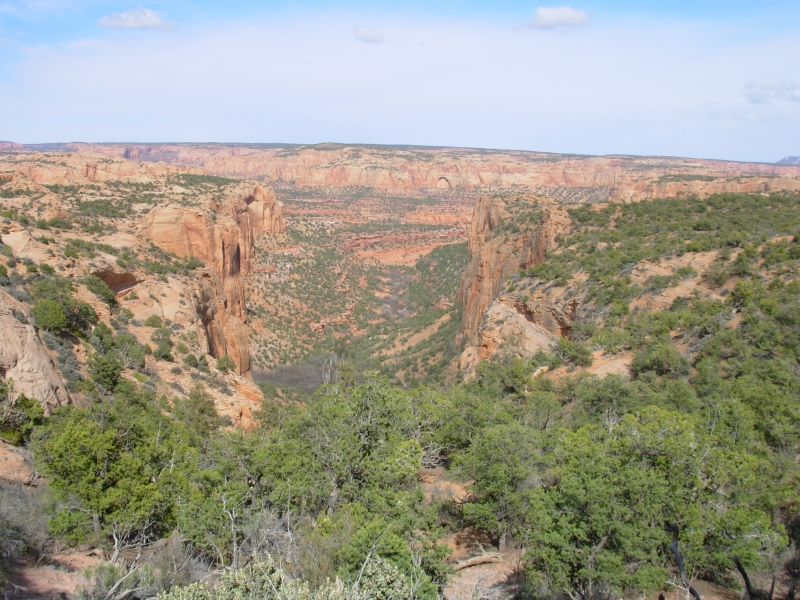
Monday, April 16: 3 miles - Navajo National Monument
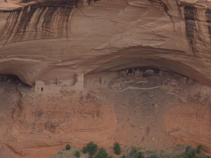
We enjoyed a peaceful night at Cottonwood Campground. We woke to cool temperatures (about 45) and dark clouds. After breakfast we finished visiting the northern rim of Canyon de Chelly, admiring the various ruins visible far below. The ooh-ah factor was less than yesterday, perhaps because we knew what to expect in viewing the red cliffs and hidden ruins. After a brief stop at Bashas grocery to pick up ice and milk, we continued north past more sandstone bluffs and pinnacles. Its a pretty drive, though you do have to watch out for stray dogs, horses and sheep on the road.

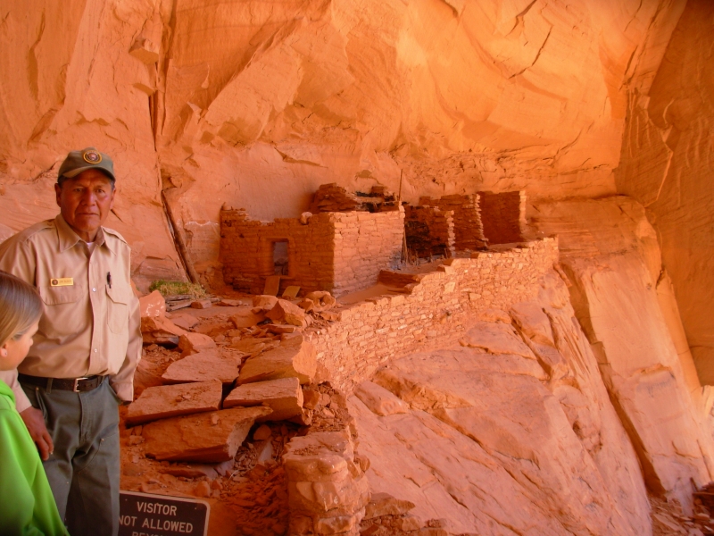
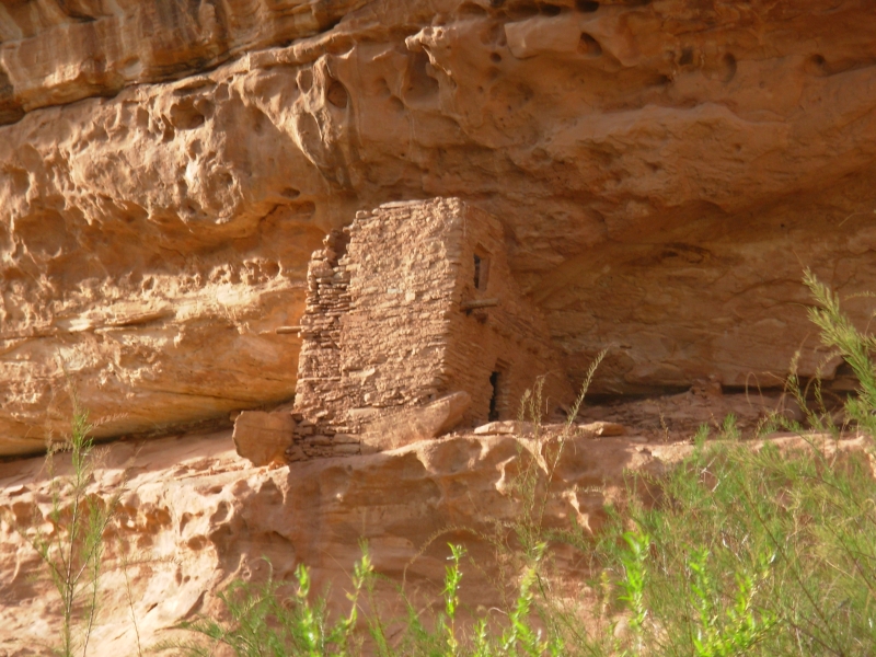
Early afternoon found us in Navajo National Monument. There are two good ruins there, both accessible only via free ranger-led tours. Keet Seel isnt open until May, except once every every two weeks as a long dayhike led by a ranger. (In the summer you can do it as an overnight backpacking trip, which is what most people do. A ranger is stationed out at the ruin all summer to keep an eye on the place and conduct tours of the site.) The next tour is next Tuesday.
We signed up for tomorrows tour of Betatakin, then did the shorter hikes around the Visitors Center. One led to a nice viewpoint above Betatakin; the other dropped 300 into the canyon, demonstrating how the vegetation changes as you drop into the cool damp shade of the canyon, so its as if you were climbing a mountain instead of descending one. At the rim theres sage and piñon and juniper, deeper in theres Douglas fir, deeper still you find aspen. It was a steep climb out, but worth it.
Then we had some time to relax in the sun at the campground. Earlier, we walked in snow flurries, but the clouds lifted and the sun came back so we were able to take off our jackets. We sat in the back of the truck reading until dinner time. As we waited, it began to hail, lightly. No rain, just hail. Weird.
Navajo NM is a small park, but worth a visit if you are willing to hike to see the ruins. Even the Overlook Trail requires a one mile hike. The Betatakin hike is 5 miles long and the Keet Seel trail is a 16 mile round trip from the parking area. Its not for everyone, but it is beautiful.
April 17 5 miles in Navajo National Monument (Betat'akin)
We enjoyed the hike to Betatakin this morning. Our guide was a local Navajo volunteer. He had a lot of stories and information about plants, the ruins, his life and family, Navajo governance, etc. He has had an interesting life: rodeo bull rider, teacher, rancher... He said that when he was a baby, his mother would ride horseback with him in a backboard, though they are rarely used any more. It was funny to hear that after seeing the backboard the other day.
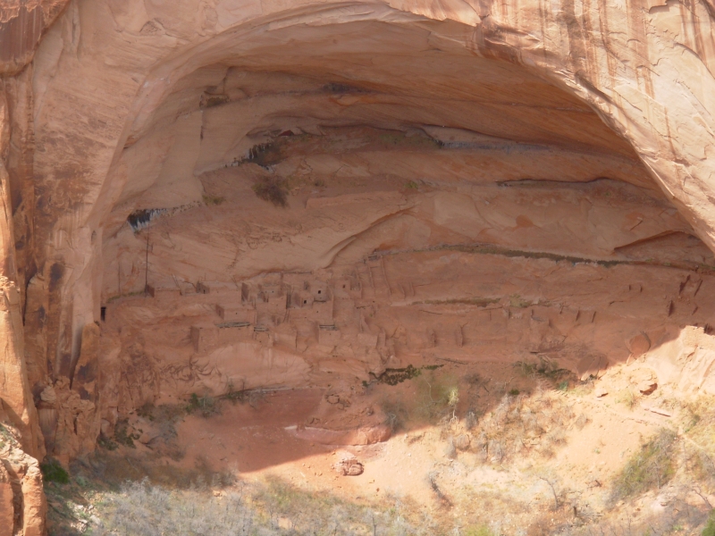
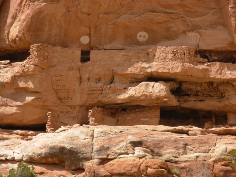
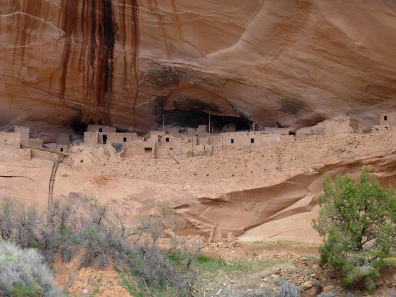
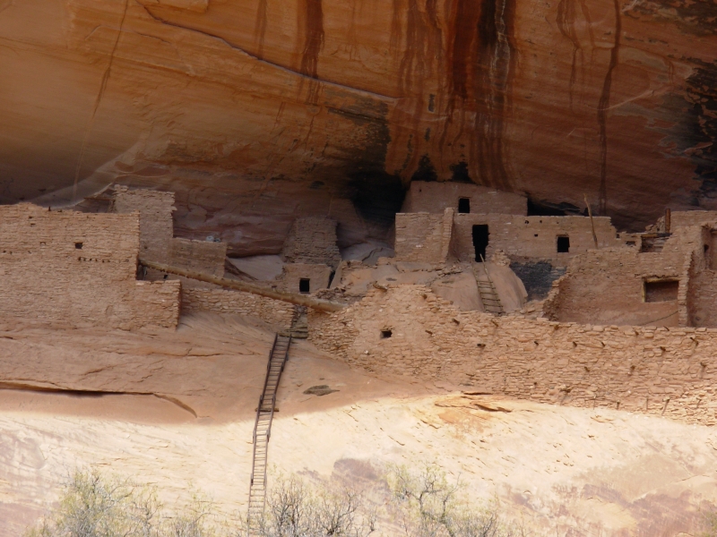
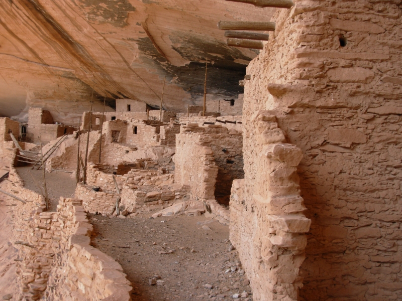
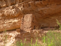
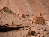
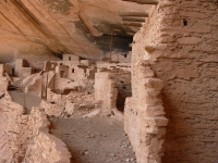
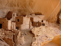
The Betat'akin ruins were in a beautiful alcove. In December it gets sun; in June it is in shadow. The Anasazi were smart builders. There were a few petroglyphs and pictographs. The ruin had about 100 rooms. Some remain whole, some were only partial rooms. It was only inhabited for about 50 years. Considering the amount of time it would have taken to build the many-storied buildings, that is surprising.
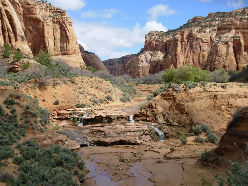
The valley below the ruin is pretty, with richly colored sandstone walls, springs and a stream. It goes on to meet the larger Tsegi Valley, which is where Keet Seel is located. We signed up for next Tuesdays tour of Keet Seel. That is supposed to be the best preserved of the Anasazi ruins, probably because it is so remote.
The hikers in our group were diverse: a family from Vermont on spring break, a couple from Durango, a teacher and her friend who is a beekeeper in France, and two young men from Eastern Europe. It was a slow hike because we stopped often, but no one got impatient.
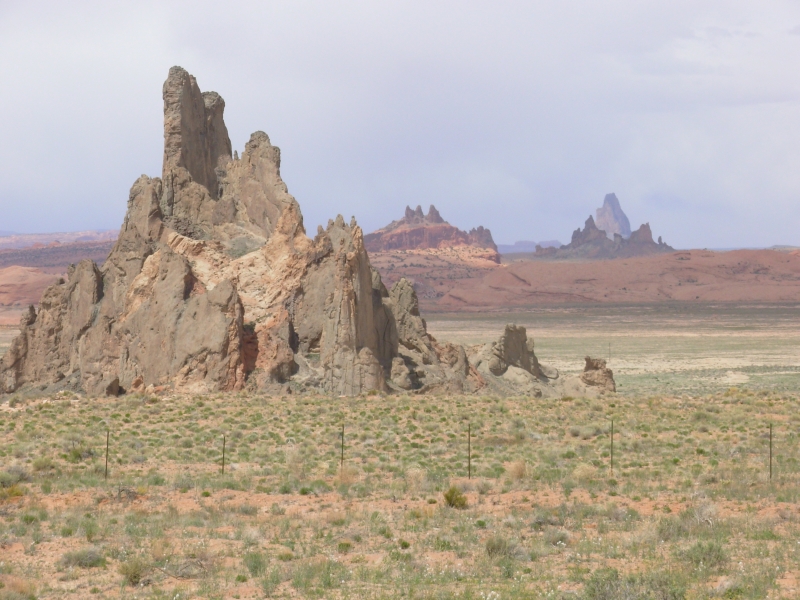
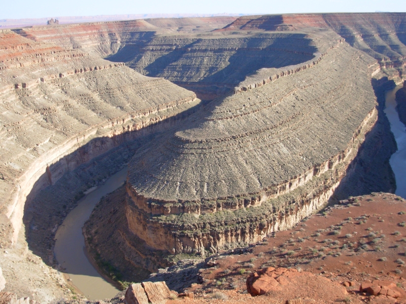
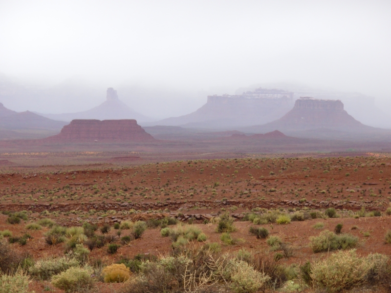
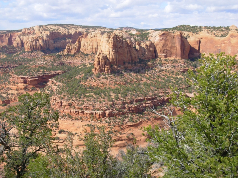
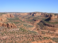
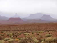
We left the Park and headed north. The drive through Monument Valley was beautiful, with red mesas and pinnacles in every direction. We detoured to Gooseneck State Park to view the meanders of the San Juan River from above. It was rather incredible the way it twists and turns. To the east the mountains are pink and gray, in zigzagging layers. Purple and blue mountains rise in the distance, far above the closer red peaks. Its beautiful. The land is very arid high desert, with sage and rabbitbrush, but no trees in sight.
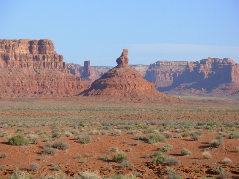
We ended the day by driving a dirt road through the Valley of the Gods, an open valley with scattered rock formations. Its BLM land, so camping is free. Its beautiful, remote, wild country. There are several groups camped out in the desert, but heres plenty of room. We found a lovely spot with cliffs in all directions, one of our more scenic campsites.
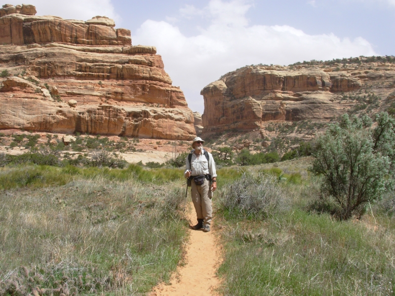
April 18 12 miles to Step Canyon in Grand Gulch
We drove the long way around to the BLM Ranger Station at Kane Gulch where I was amazed to be told we could get a permit today to hike the canyons of Grand Gulch. After running into the problem of Paria Canyon being booked two months ahead, I didnt expect it to be this easy.
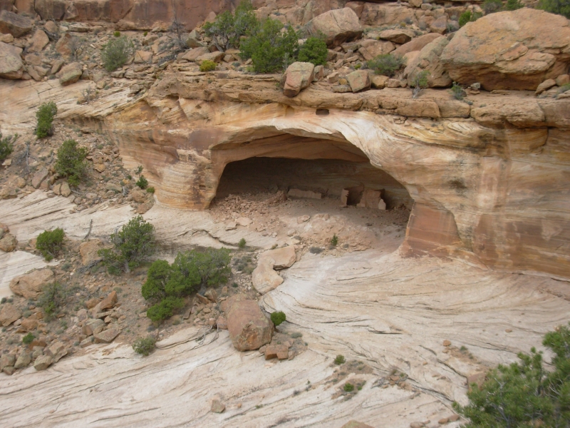
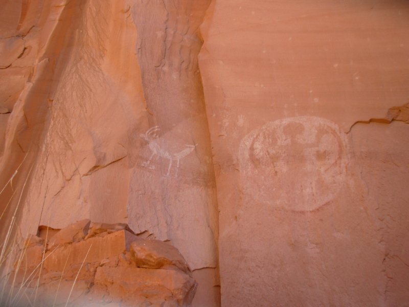
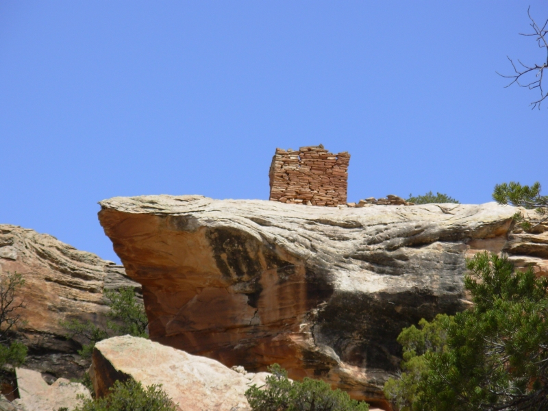
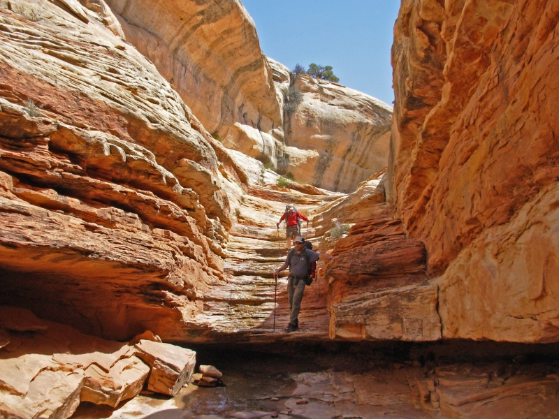
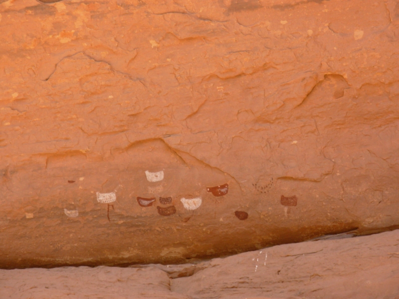
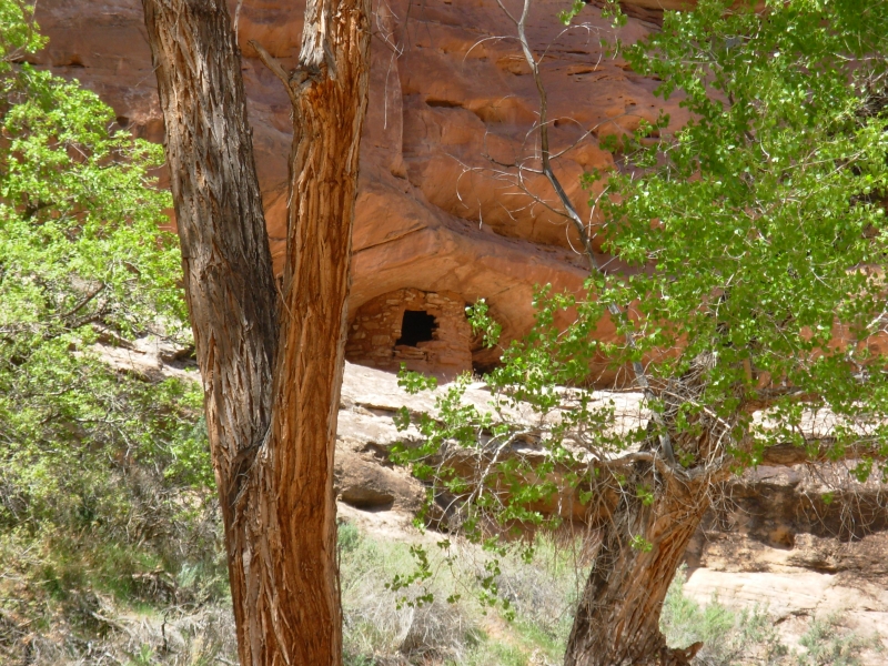
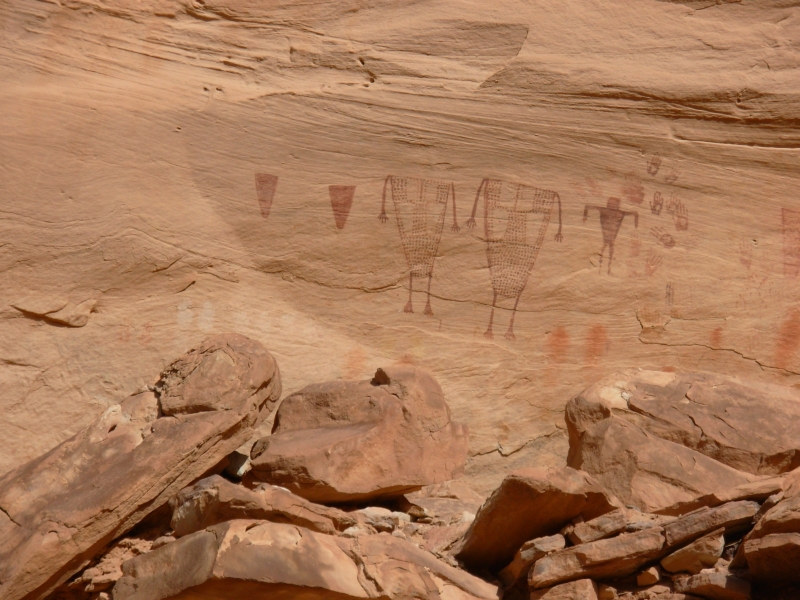
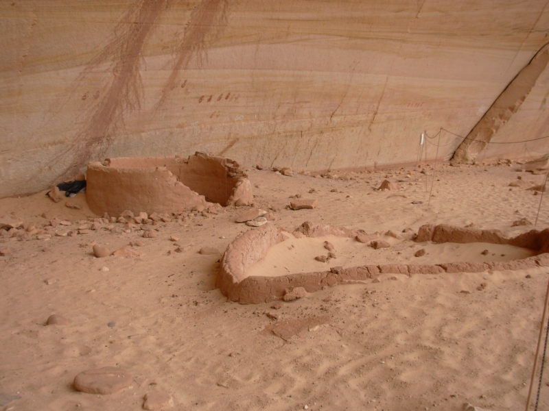
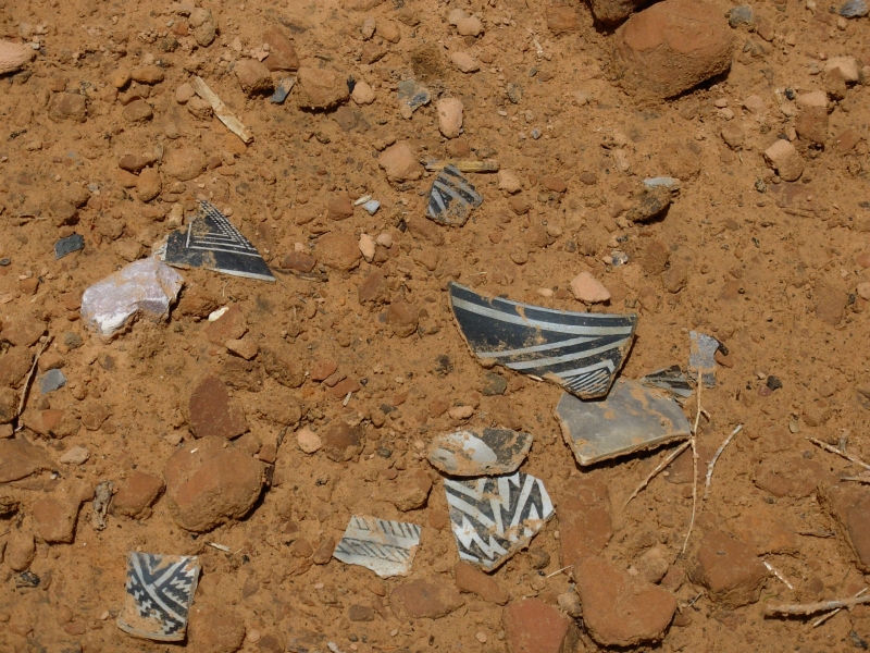
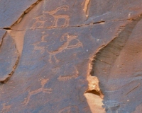
We had to get our packs ready, so we didnt leave the Bullet Canyon trailhead until noon, heading down toward Grand Gulch. It was an interesting start, with a pictograph panel and stone tower within the first mile, then a long section of slickrock. After that, things settled down and we followed good trail through the canyon for 7 ½ miles to Grand Gulch, which we followed downstream for four more miles. We saw five certain ruins and a few possible ones, with two good pictograph sites. One had three clan/shield signs, one dark, one with stripes and one with two circles (eyes?) Interesting. The canyon is sandstone, striped black, red and white. Its hard to tell whats a pictograph and what isnt.
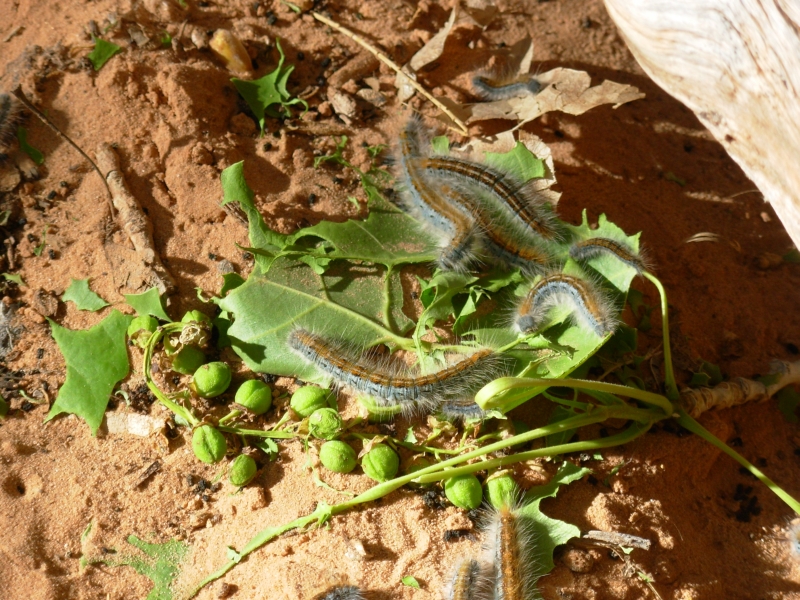
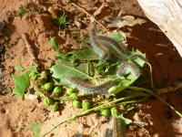
We met a lot of people, mostly heading the other way. We leapfrogged one group that started when we did. The area is rife with caterpillars. It sounds like rain as the chewed leaves fall from the trees. When we sit down for five minutes, were covered with little caterpillar bodies.
We missed an important trail junction at a camping area earlier, but somehow ended up on the right trail heading down the canyon. I have no idea how we did it, but we were lucky. I wonder how many people end up going down Grand Gulch instead of up it? Well have to be careful that we dont end up going back up Bullet Canyon instead of up the main canyon. It was frustrating looking for a junction that never came. But there are lots of good campsites under the cottonwood trees.
Water was intermittent. I'm glad we're hiking now and not a month from now. By mid-May the water is probably all gone. Near our campsite its very stagnant, so Jim went up a side canyon looking for a spring while I attempted to set up camp. The tent fought back. It was very windy all day, with sand blowing in our eyes. Its cool here at 5600 when the sun goes down. The wind kept us cool earlier as we walked.
Grand Gulch is known for its many Anasazi ruins. Ive wanted to hike there ever since I first heard about it years ago. Getting a permit and having the time to stretch out the hike is wonderful. I was surprised at all the people we met, but I guess I shouldnt be. You can dayhike the ends and there are five trailheads into the main area, so lots of loops are possible. The most popular hike is Bullet Canyon to Kane a 23 mile semi-loop. (Its 7 miles by road between the trailheads an easy hitch.) Were adding part of the main canyon down to a good pictograph panel 8 or 10 miles down Grand Gulch, so well double the middle section, then head out to Kane Gulch Trailhead. The BLM ranger suggested that it is easier to get a ride from the Visitors Center back to Bullet Canyon than to get a ride from Bullet Canyon to Kane Gulch. Well see.
April 19 17 miles to Confluence of Grand Gulch and Bullet Canyon
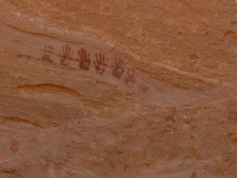
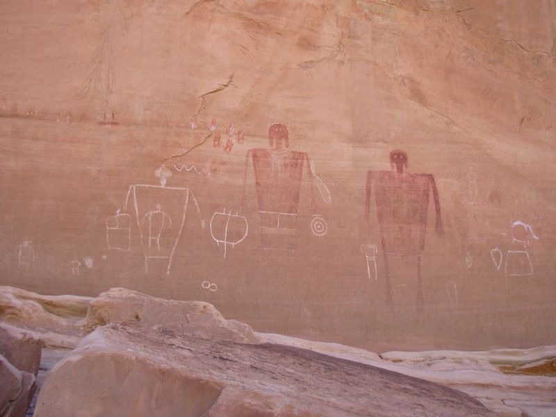
We ended up going farther today than we intended when we missed seeing the Big Man Panel that was supposed to be our turn-around point. When we were sure that we had missed it, that it wasnt just around the corner, we continued to Polly Canyon where there is a ruin and a trail junction. We ran into a couple of day hikers there and a group of backpackers who were camped nearby. One of the backpackers told us what to look for to locate the Big Man Panel (a cairn and steep sandy trail up. She didnt mention that it was the second cairn. Oh well, we didnt go too far up that cliff!) We turned around at Polly Canyon and eventually found the right trail to the pictograph panel. It was a good one, with two big red people, several white ones, 30 hands and other unknown images. We had missed it because we were following a trail that was very close to the side of the canyon so the perspective was wrong to look up and see the alcove with the pictures high above us. When hiking in the canyons around here, there are often multiple paths and no official trail. You just have to make your way as best you can.

It was a nice morning with easy walking, mostly in the wash, occasionally above. There was less zigzagging up and down over ridges and across water than yesterday, so it was less tiring, though walking in soft sand can get wearing. We did a fair amount of sliding down sandy banks sand skiing! Going up is harder. Pieces of petrified wood appeared among the river rocks. I wonder where they come from. There were lots of birds and lizards, but we saw only one snake. We also passed three ruins this morning, including the one high above Polly Canyon. One had pictographs. There was another large pictograph panel in a big alcove. The pictures looked like birds maybe chickens, or turkeys or ducks? There were a lot of them there.

Our return trip was pretty straightforward. We got access to one ruin we had only seen from a distance this morning. It had only one room, but there were several pictographs. Some were yellow, which had really faded with time. We spotted a ruin late this afternoon that we missed yesterday. The adobe color really blends in, especially when the alcoves are in shadow. We spotted another possible site: we could see two sticks in an alcove high overhead, but the angle was wrong to see if there were any walls below the sticks.

Hiking here has felt like a treasure hunt as we look for ruins and pictographs. For some reason, the people in this area painted pictographs rather than carving petroglyphs. What is really amazing is how untouched the area feels. Weve seen no obvious vandalism, despite the fact that the ruins are so accessible.
We hiked too far today, but campsites were scarce for a long way. The only one we saw was covered in caterpillars. So is the one we ended up in, but its later so theyre less active. Were beat, but happy.
Friday, April 20 13 miles to Junction Ruin
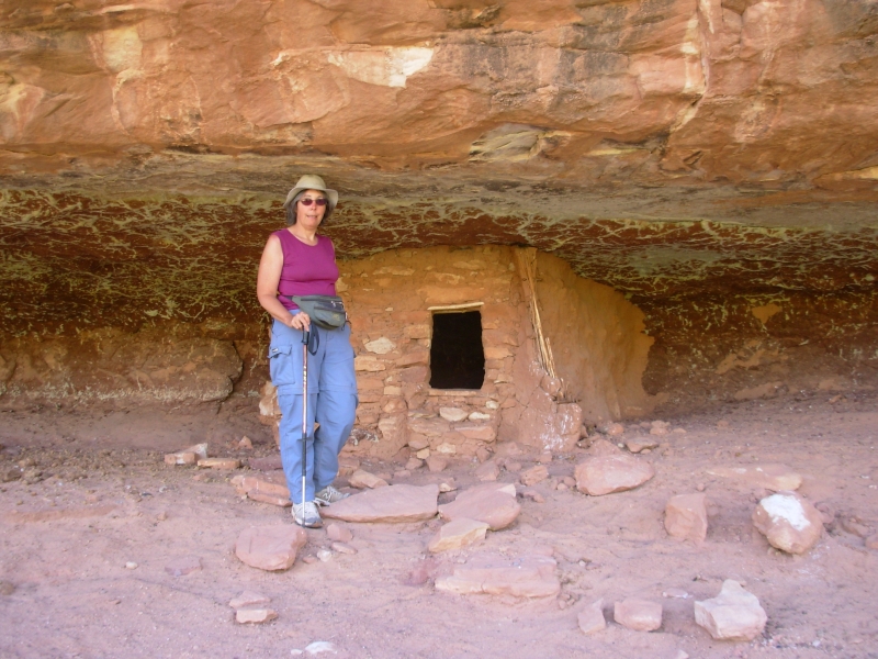
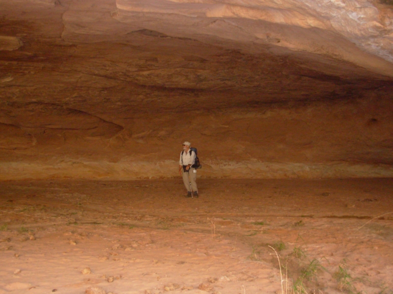
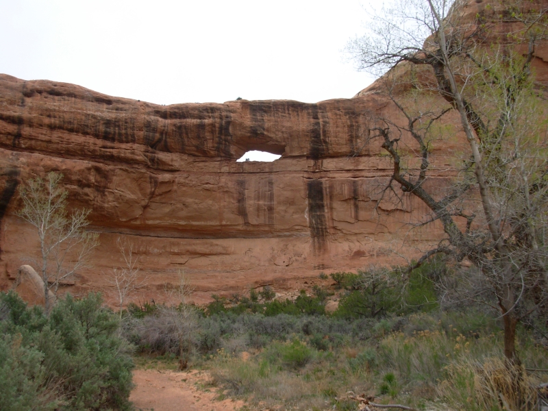
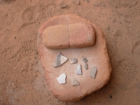
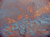
The wind and clouds have come back. The forecast was for rain/snow on Saturday, but it may be here early. We had a really good morning as we headed up Grand Gulch on new (to us) trail. We detoured up a couple of side canyons. The first led to a really big alcove, a lot like one we saw in the Grand Canyon on our river trip two years ago. The second led up Sheik Canyon, to some very old ruins with walls and ceilings covered in rock art from many different eras: archaic, basketmaker, and Anasazi. There was an ammo box that had a notebook which explained the significance of what we were seeing. I really appreciated having that information. There were figures, some with heads, some without. Some of the figures were pecked pointille style. There was an unusual green mask, some animals, lots of handprints, white figures, counting sticks, and many others all interesting. In the ruins was a cache of old corn cobs, some arrow heads, an arrow straightener, a few pieces of pottery, etc. We spent an hour at the one site, and Im sure we didnt see it all.
We saw three other ruins before lunch. One was obvious--it had towersthe other two were barely there, but we could see a few walls. Unfortunately, the ceiling of the alcove collapsed and took out most of the walls. Sometimes its hard to tell which is a ruin and which just stone, but thats part of the fun. We had the trail to ourselves all morning. Nice. Water was a problem though. The creek runs intermittently, with some stagnant pools. The side canyons had good water, but we left our packs behind so didnt fill up. Finally we headed up Coyote Canyon, which has a good spring, and decided to have lunch. Its a pretty place for a long break. In a couple of weeks this area will be too dry for backpacking. We got lucky in our timing.
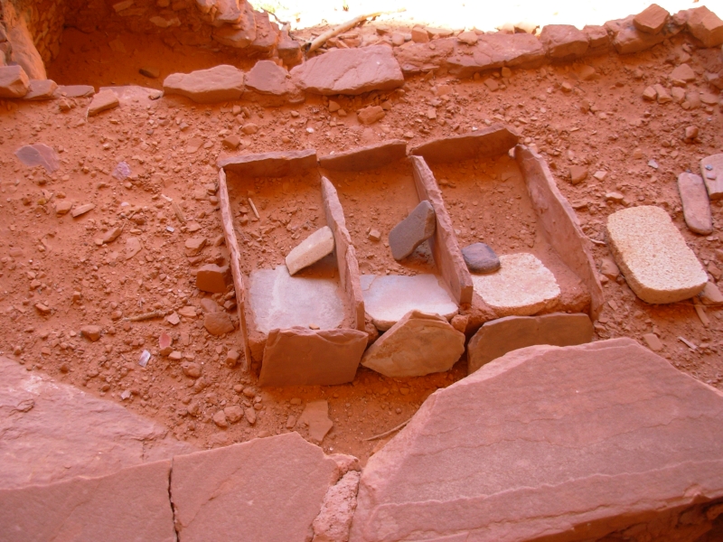
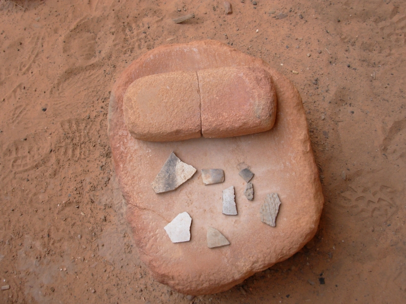
Our afternoon hike continued to surprise us with frequent ruins. Our days total was 13. Several were close enough to the trail that we could wander through them. Three had information notebooks in ammo boxes explaining the ruins. Several were on multiple levels, with some walls at ground level, some higher and some way way up on a narrow ledge. One had about six different levels. There were pictographs and a few petroglyphs. One had a rock covered with carvings, but they were too far to see clearly. The middens (old garbage heaps below the ruins) were fenced off but you could see lots of pottery sticking out of the dirt. There were a couple of whole metates with manos (grinding stones, used to grind corn). I was surprised to see them, given the looting that went on in the early days and still does in many places. Of course, few backpackers are willing to carry heavy stone bowls or tools, but even so, it amazes me to be able to wander so freely amid ruins built 800-1200 years ago, and to see rock art that may be several thousand years old. I am in awe of this place. It has been an incredible hike, unlike any other Ive every done. The canyons are beautiful, especially with the spring greenery and flowers. The cliffs twist and turn. There are rock towers and spires and even an arch or two. Apart from the ancient sites, it would still be a really good hike. With the ruins, it is an incredible one.
Saturday, April 21 4 miles in Kane Canyon Motel in Blanding
Today was a day with a few minor mishaps, but nothing major. It rained in the night and again as we were driving to town and the temperature dropped considerably. Ive been hiking in a t-shirt, but at noon it was only 45. Brrr! Some people at the Ranger Station said they had had snow last night and this morning.
Our walk out of the canyon was mostly an easy one, though we passed no ruins in the four miles from our campsite to the road. We missed a turn on some open rock and ended up trying to climb over a lot of rock-fall in the stream. Those were BIG rocks, 10-20 feet tall. We soon realized that we must have missed something, so we turned back and found a fallen cairn (which we repaired) leading in the opposite direction. We met two groups of backpackers and one group of dayhikers going in. We talked for a few minutes with a man who had section hiked the PCT. He and his wife were out for four days.
At the ranger station, Jim quickly got a ride back to the car, seven miles away. I waited and looked at the book display. Jim didnt come back. I waited and waited and waited. An hour went by and I was getting worried. I talked to one of the volunteers who said if he didnt appear they would run me out to the trailhead. Finally, Jim turned up. When he got to the car he found we had a flat tire. The lug nuts were frozen so it took a long time to change it. Besides, there was the problem of setting up the jack in the sandy soil. We drove to the nearest town, Blanding, about 40 miles away and learned that all the tire shops in the area are closed all weekend. Do we dare drive these roads with no spare?
In the meantime, we got a quick lunch at the A&W, then took a most welcome and overdue hot shower, followed by an equally necessary trip to the laundromat, then the grocery store. I dont think the grocery will be open tomorrow as its Sunday, so it seemed better to take care of errands today. This is a Mormon town, so chances are most businesses will be closed on Sunday.
April 22 3 miles another night in Blanding
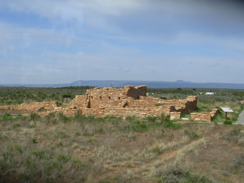
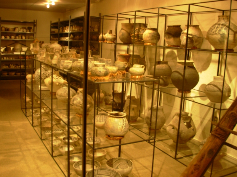
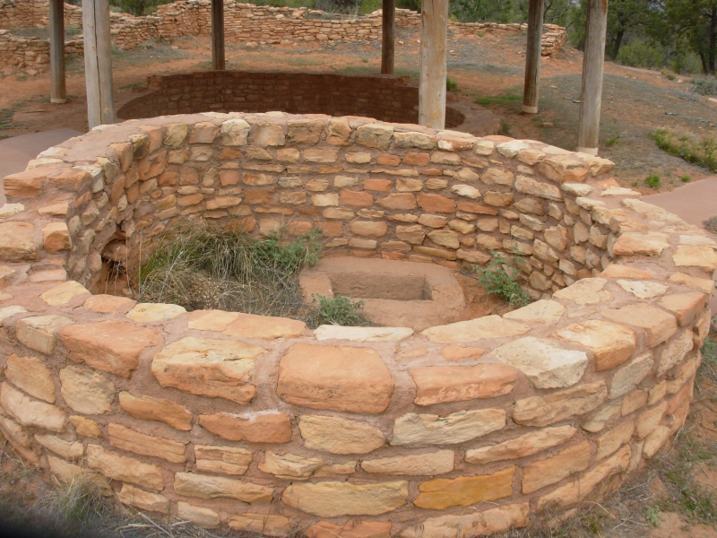
We had a slow-paced touristy day, driving from Blanding to Natural Bridges and back. We started at Edge of the Cedars State Park which has a ruin and a nice museum with artifacts from the Cedar Mesa area, as well as more modern Indian art. It was well presented. Then we headed west, stopping at two more ruins; Butler Wash and Mule Canyon. Butler had a short ½ mile walk to an overlook where we could see ruins in the canyon below. Mule Canyon was heavily reconstructed but had a good example of a Great Kiva, but without a roof.
One of the exhibits I enjoyed at the museum this morning was a wall that told stories about major finds that were discovered by ordinary people out hiking. I think every hiker in this area dreams of finding a previously undiscovered intact pot or other treasure. The museum was encouraging folks to report their finds to the archaeologists rather than sit on them (or worse, taking the artifacts home). I enjoyed reading the stories of people like us and what they found. It is still possible to discover something new.
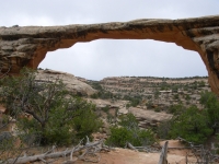

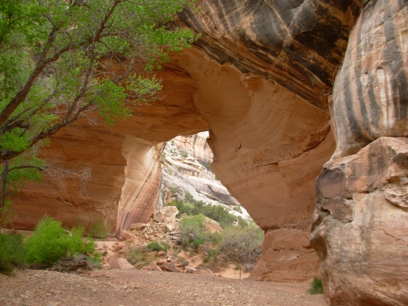
Then we headed on to Natural Bridges National Monument which has three very large natural bridges caused by a river cutting through a meander. (Natural Bridges are caused by flowing water cutting into rock, while arches form by other natural forces that crack off pieces of rock to create an arch). The weather was very threatening gray, cold and windy so we didnt do the 8 ½ mile hike through all the arches. Jims knees were hurting from all the short steep sandy climbs in Grand Gulch, so he wasnt interested in any serious hiking today, especially given the gloomy weather. It spit on us a couple of times, but not seriously.
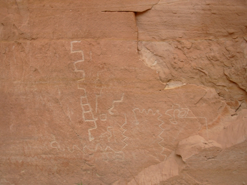
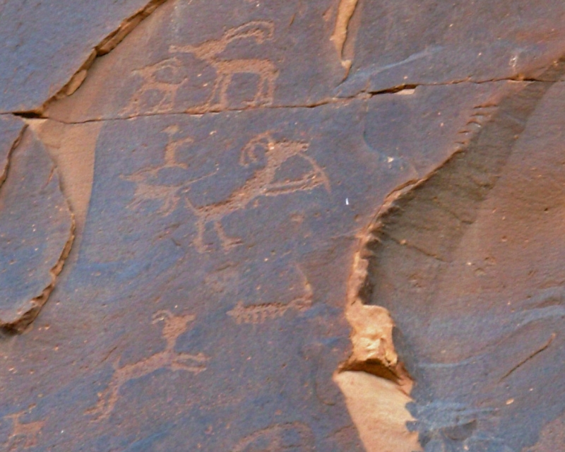
We ended up just walking down to the last two arches (Kachina and Owachomo) and visited the overlooks for the biggest (Sipapu) and the Horsecollar Ruins. Kachina was interesting because it had a small ruin beside it and petroglyphs and pictographs on both sides of the arch. Most were hard to decipher because they were carved on clean rock, not rock with a dark varnish to provide contrast. There were mazes and snakes and people and kachinas, a bighorn and map-like squiggles. It was fun looking for the rock art. The bridges were impressive; two were over 200 high. Sipapu is the third largest natural bridge in the world.
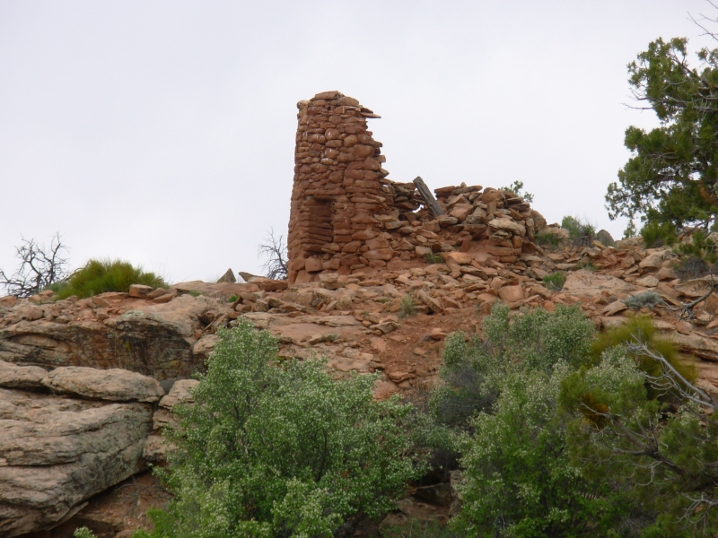
We ended the day by visiting a place with seven towers clustered around a spring at the head of a pretty canyon. Why were they built? There wasnt much left of the towers and no explanations whatsoever. There was another couple wandering about with their dogs, but it obviously isnt a major tourist stop. We were told that most of the canyons in the Cedar Mesa area have some sort of ruin or rock art. A few, like Grand Gulch, are visited by a lot of people, but most are off the beaten path, so only a few people visit them. I wish we had more time to explore.
Monday, April 23 1mi. Camp at Navajo NM
Last night we discussed plans for the next couple of weeks. Were agreed that we want to visit more of the major Anasazi sites like Chaco, Hovenweep and Mesa Verde but Im worried that we are doing so little backpacking or real backcountry hiking. I enjoy playing tourist, but I want more. Jims knee got hurt again on our last backpacking trip so hes less than enthusiastic at the moment about doing backcountry trips. Its a problem. I sympathize, but I really want to experience the remote areas, not just the tourist stops. We have a month or so before heat becomes an issue in Utah, I think. I know we cant do everything Id like to do there just isnt time. We didnt even manage to do the hikes I hoped to do here in Cedar Mesa. Maybe next year we can hike Mule Canyon, Owl/Fish Creeks and Butler Wash and go back to Grand Gulch to hike the rest of the way to the River. Well see. Reconciling my desire for backcountry experience with Jims painful knees is not going to be easy.
Getting the flat tire fixed took only a few minutes this morning, but was most necessary for our peace of mind. Were heading back to Navajo National Monument for the hike to Keet Seel tomorrow, so we didnt have a lot planned for today. That was a good thing since it started raining while we were eating breakfast and became a serious downpour just at the point where we arrived at the Sand Island Petroglyphs. That is a wall of rock art next to a campground and boat launch. There are some good carvings there: a couple of Kokopellis, a more modern one of someone on horseback shooting a buffalo, lots of bighorns, a maze, maps, etc. There is a shaman with a horned headdress playing a flute. We cant take pictures in the rain, so we sat and read for a while as we waited for the rain to stop.

When the rain slowed down we got out to look at the rock art panels. It was hard to get good pictures of the wet rock, but we tried. As we drove off, the rain stopped and the sun came out. We headed a few miles west to Butler Wash where there are more ruins and rock art. As we contemplated one ruin and tried to get across the wash to see the petroglyphs, it began to rain again. We decided to leave before the dirt road became impassible. Another couple was there whom we had seen at Natural Bridges yesterday and again today at Sand Island. Theyre heading home tomorrow, so we wont see them again, but it was funny running into them so often.
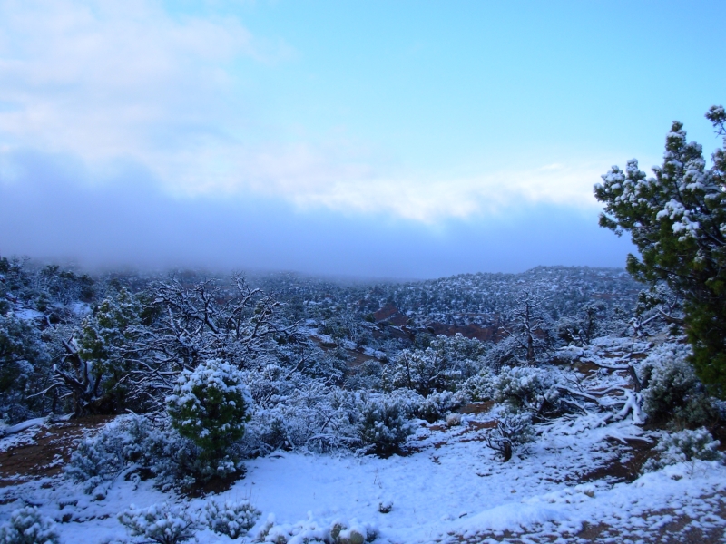
Heading south, Valley of the Gods was filled with clouds. The sculpted rocks poked up through the fog. A little later, it began to snow. There was already snow on the ridge above the road, but when we reached Navajo National Monument we were hit by hail and snow, which continued for about an hour. The campground was empty when we arrived, but a few RVs showed up later.
Tuesday, April 24 16 miles in Navajo National Monument (Keet Seel)
It snowed last night again after dinner. By morning there was an inch or more on the ground. We werent sure whether or not our hike would still occur, but we showed up at the Visitors Center at 7:30 as instructed. Our guide showed up soon after, saying she thought the hike would be cancelled because of the weather. A few minutes later she came back out to where we were waiting and told us her supervisor told her the hike was still on, but there were others coming up from Phoenix and they wouldnt be there until 8:00. We waited in the car where it was warmer. Sure enough, they arrived just before 8:00.
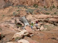
We drove a mile or two to the trailhead, where the mountain top was still covered in cloud. Soon afterwards the sun broke through, the clouds lifted and the snow began to melt. We ended up with a beautiful day to hike: some clouds, some sun, temperatures in the high 40s. The hike was a really good one. Tsegi Canyon is beautiful, with big sandstone cliffs and rock formations There were arches and caves and wind- and water-carved rocks. We followed the creek, passing three waterfalls. The ground was very muddy near the creek, with some quicksand, so we ended up covered in red goo. We crossed the creek numerous times. It wasnt deep, only a few inches, and often we were able to jump across or rock hop.
The group was small: just us and a couple from Cottonwood, Arizona with her brother from California. Our guide was a local Navajo woman who was a soldier for two tours in Iraq. She left the Army because she was homesick. Her supervisor told her to get us back in eight hours, which was absurd since the hike is 16 miles round trip, plus we had a lunch break and spent an hour or so touring the ruins at Keet Seel. There is a 1000 climb in the last mile. Eight hours for all that? Right! The other hikers were in their 60s-70s, in good shape, but not really fast, especially as the day wore on. We ended up pushing hard, and I resented feeling like we couldnt take the time to take photos without slowing down the whole group. Even so, the hike was beautiful and very worthwhile.

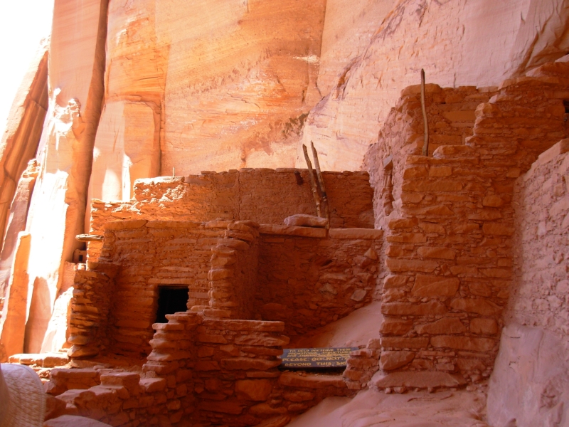
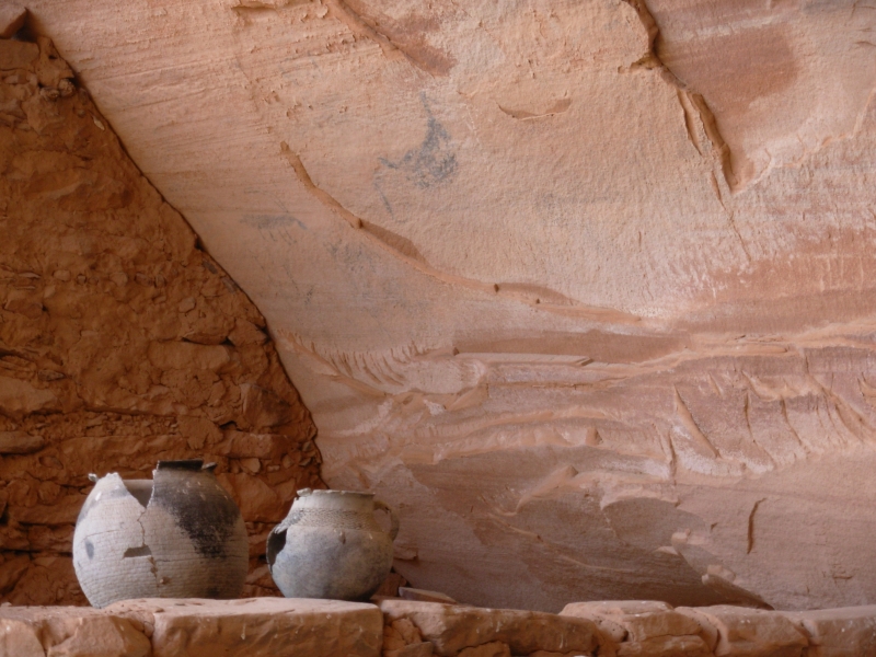
The ruins were awesome. They were well preserved and not much picked over because of their remoteness, so there were lots of details lacking in most ruins, like beautifully patterned pottery shards in the midden, hangers in a store room, original 800 year old rope holding the roof beams together, a piece of necklace on the ground, pots up on a wall, etc. Many of the buildings still had roofs, and most of the walls, doors and windows were intact. It was fascinating. We climbed up on ladders and wandered into several rooms. I learned that human waste was sometimes mixed into the mortar in these old buildings, which I hadnt heard before. Adeline said that when she took her mother on the tour, her mothers first comment was, It doesnt stink the way they usually do. It does answer the usual question of what was done with the waste, since there were once 100-150 people living there.

We made it back to the cars before the rains hit at 5:00. We all felt pushed by the pace and Adeline still ended up working unpaid overtime.
We really enjoyed the hike. The site is so remote. There are no houses en route, and just a few cows and horses grazing. A jeep road follows the wash up to the first waterfall, but its strictly 4WD. Getting stuck crossing the stream multiple times would be easy. The only people who use it are the rangers, occasionally, and a few locals who live downstream.
It was so beautiful, a lot like Zion in color and dramatic beauty. Keet Seel was worth the exhaustion and sore muscles we felt at the end of our day. We didnt take as many pictures as I would have liked because of the brisk pace, but we took enough.
Afterwards we decided to eat dinner at the Anasazi Inn about 15 miles from Navajo NM. I was cold, wet and tired and not in the mood to cook at the campground. Then we continued east to New Mexico, ending in Farmington. We tried to visit Four Corners Monument, but it was closed when we arrived. It was a pretty drive past Shiprock. We could see snow-covered mountains not far away.
Home | Links| Trail Journals |
The Thruhiking Papers | Bun-bun
Created: 10 November 2007
Revised: 30 Sept 2016Copyright © 2007-2017 Spirit Eagle