|
 |
 |
 |
 |
|
|
|
|
|
|
A Short Tour of the CDT in Southwestern Colorado
August 6 - Campsite at headwaters of Ruby Creek - 13.1 miles - Total 66.4 miles
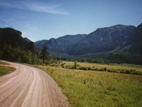
Ginny: We ended up last night with a bad Mexican dinner, late to bed and unable to sleep. Too soon, morning broke - bright and beautiful. We enjoyed a good breakfast with Kathy and Larry (our hosts), two couples from Texas (most of the tourists in Colorado are either Texans or French), Kathy’s son Tolan and his friend, just back from 5 weeks in Ecuador. Larry played the piano while we ate breakfast, including a lovely "San Juan Suite" that he composed. He then drove us back up to the trail (about 20 miles) and we started hiking at 10:00. It is a lovely drive, with incredible views at the pullouts. We stopped at a couple of viewpoints both coming and going to Spring Creek Pass. Beautiful mountains all around. The weather was beautiful - cool and sunny with clouds building up and passing by.
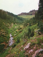
We climbed out of Spring Creek Pass and could look back to see Snow Mesa’s rim (where we hiked yesterday), and ahead to today’s hike along the Divide, and clear to the Rio Grande Pyramid to the south which we’ll hike past next week. There was an interesting formation called Bristol Head - which does remind of pictures of England’s coast. There were snowy mountains in all directions. Uncompahgre is very dramatic, and Red Cloud and Red Mountain distinctive in their coloring. Sunshine is another fourteener, and pretty distinctive too. The snow doesn’t cover the mountains, it streaks them. Up close they are just scattered patches of snow, but from afar, they look pretty dramatic.
We spent the first 9 miles today on the Jarosa Mesa, following a jeep road over rolling green hills. After the first mile or two there were few trees except for a lovely grove near Buck Creek at mile 10. It would have been a good place to camp, but we needed to make more miles, so on we went. As lovely as the morning and noontime was, the afternoon deteriorated. It began to rain at about 2:00, just as we passed a herd of sheep. Their shepherd was in a small mobile hut up the hill. He came out and waved at us as we passed by. At first it just spit at us, then it became a steady rain, then the clouds moved in and we were totally socked in.
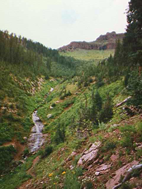
Water is pretty scarce along this section, so we had to bushwhack to a creek that was off the trail. We turned off the trail too soon, so climbed back up and crossed a knife-edge with sheer drops on both sides, then eventually found the right valley. It seems to be quite dramatic under snowy cliffs, from the occasional glimpses we get through the clouds. We had to drop a couple of hundred feet in elevation to find a flat spot. By that time, we were soaked and freezing, so we threw up the tent and crawled in.
It took us a long time to warm up. Two hours later, we’re still socked in, so we’re having lunch for dinner instead of trying to cook (gorp, granola bars and cookies). With luck, morning will be better. My ankle is killing me. I have some sort of bruise on the bone, and the boot rubs against it. Otherwise we’re okay.
We hiked about 13 miles, despite our late start. No wildlife except birds, though Jim saw a deer in the trees. We met a forestry person looking for a hidden spring. He kept passing us on the dirt road, stopping the truck and wandering off into the brush, and returning to the road to try again. He never found the spring. We met five people on horseback. They really tore up the trail. It is so muddy, they were slipping and sliding and sinking 6-8" deep. The ATV that ignored the "Trail closed to motorized Vehicles" sign just after we left the jeep road, did even more damage. That was recent, today or yesterday. The only hikers we saw were some guys camped at the trailhead at Spring Creek Pass.
I feel pretty good. The weather is a pain, but endurable especially since the sunny hours are so glorious. My ankle is a serious concern. I don’t want to stop hiking, but by the end of the day my left ankle was in agony. I can’t hike like that. Especially since, by trying to compensate for the problem and hike with my foot in certain positions that prevent the rubbing, I could screw up the rest of my body. We may end up drastically shortening the hike, which I would hate. [NB: I found a way to wrap my ankle with an ace bandage above the bone so that the boot stopped rubbing against the bruise. It didn’t get rid of the problem entirely, but it sure helped.]
Jim just keeps on smiling. He bears his own aches and pains better than I do, agrees to cookies for dinner with a grin, and is a great companion all around. A better partner can’t be found. When we lay in our sleeping bags shivering and trying to warm up, I was looking for distractions, so I thought, "Okay, I’ll sing to myself." The only song I could come up with was, "On a clear day, you can see forever . . ." Given the dense fog outside, we both had to laugh.
Jim: The morning was just great - it was clear and we could see mountains all around us - including the Rio Grande Pyramid. We probably should have camped at Big Buck Creek - it started raining on us a couple miles earlier - but we got into the thruhiker "gotta make miles" mode and kept going. Unfortunately, the trail headed up above treeline and there wasn’t much in the way of camping up there. By the time we got to Ruby Creek, we were a little too close to hypothermia for comfort. We had to drop 300 ft off the ridge to find a place to camp - and we were still at 12,500. It took us a couple hours to warm up - and that’s not happiness. The tent was only a little wet after we spent yesterday afternoon trying to dry it out, but it’ll be wet again in the morning - the fog rolled in as soon as the rain stopped.. The sleeping bags are also coming apart at the seams - and they’re not very effective. I guess I shouldn’t be surprised - they’re the same bags that made the AT thruhike in 92 and they’ve been in constant use since then.
Water II - there are no "good" water sources here. Almost all the streams are born in snowpack - and I have yet to see snowpack here that isn’t RED. Don’t eat RED snow. In addition, even the local literature makes no pretense that the local water sources might not be contaminated by at least Giardia if not other, nastier livestock. And given the proliferation of cattle and sheep, a good water filter is a necessity.
August 7 - Meadow near Pole Creek - 14.9 miles - total 81.3
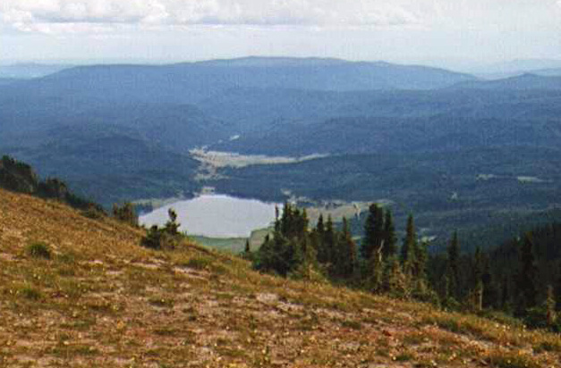
Ginny: The fog was still there when we awoke, though the sun tried to burn through from time to time. We cooked breakfast at the door of our tent, still wrapped in our sleeping bags, then made the long slow climb back up to the trail. As we came over a rise, the clouds cleared and we had a fantastic view of the valley below, with Lake San Cristobal, Sunshine, Red Cloud, Red Mountain, Handies Peak and many others. That view came with us up the climb, just getting better and better the higher we rose. Clouds still filled the valley to one side, but on the other was mostly sunshine. There was a lot of climbing for a while along the Divide, over promontories, down to saddles, then back up again. We detoured around one snowfield and ended up slipping and sliding in mud and loose rock instead.
Coming down the final knob we entered a different world. All of a sudden there were jeeps, ATVs, and dirt bikes everywhere. This was Carson, a deserted old mining town, with mostly just a few wooden walls and scars from the mines remaining. Only one building still had four walls, sort of, and no roof. But it is very accessible if you have four wheel drive. Four wheeling is very popular around here, it seems.
We also ran into a trail crew working on the Colorado Trail there. There were about 20 people out for a week, digging side hill and putting in culverts. We ate lunch there with them, then followed the dirt roads out of town. We met 3 Colorado Trail thruhikers at a road junction. We had been following their footsteps our first few days, but they got off in Creede for a day or two. They stopped soon after we met them to camp somewhere on Lost Trail Creek as they had done a 20 mile day already (it was 2:30 or so then.) We saw three more backpackers wandering in the willows below us (trying to follow the stock driveway or Jim Wolf’s route?) And then three more who caught up to us at the pass between Lost Trail and Pole Creeks. They stopped to camp there, so we never saw them again either. Lots of people.
We also spoke with a forester, Roberto Garcia, who was very interesting. He and Jim discussed the possibility of seeing grizzly bears (remote - but not impossible). We climbed gently for four miles along one creek (Lost Trail) then descended gently for four more along another (Pole Creek). Total for the day was about 15 miles. We’re exhausted. We had mostly sunshine, though it clouded up and sprinkled from time to time. It stayed cool all day though - I never did put on a short sleeved shirt, I just wore my long underwear all day. We finally collapsed shortly after the CDT separated from the Colorado Trail.
Up to now they have coincided and maintenance and marking have been primarily done by the Colorado Trail people. The turn was not marked at all. If the directions in the guide book hadn’t been good, we might have wandered quite a while before realizing that the sharp turn to the right we passed was not just a stray horse track, but the CDT. There were two important unmarked junctions there. It’s not the Shenandoahs, that’s for sure. The first half mile or so across a meadow and up a hill weren’t marked at all either.
Again - the guidebook saved us. I hope this isn’t an indication of things to come. We had three wet foot stream crossings this afternoon - one was knee deep. I’m glad we brought Tevas. We’re camped in some trees below the meadow at the top of the hill. Lots of evidence that cows use this place as a campsite too. Coyotes are yipping up the hill. I’m cold and tired - so goodnight!
Jim: When we got to Carson Pass, some of the trail crew were friendly - and some of them lost interest as soon as they found out we were hiking the CDT rather than the Colorado Trail. We ran into this attitude several times and it was very noticeable. One of the crew was an AT thruhiker - Grey Owl, ‘91. He’d also hiked the Colorado Trail in ‘92 and very obviously had been thinking about the PCT. Another one was sectioning the Colorado part of the CDT. The 3 CT thruhikers that we met a little later didn’t show a lot of interest in the CDT either. I owe the forest service person some pictures - he’s the only person I ran into in Colorado who has any belief in the possibility of grizzlies in the San Juans. Everyone else thinks the last grizzly was killed a long time ago. The last couple miles today was pretty tough - it was all down hill after Lost Trail Creek Pass, but the trail was torn up by horses on the northern (Lost Trail Creek) side of the pass and by dirt bikes on the Pole Creek side. Our campsite was at 11,300 ft and wasn’t particularly comfortable - too many humps, lumps and cow patties. We even moved the tent to get away from some of the lumps – to no avail – we simply found a new set.
Sunscreen - Doesn’t matter how well you tan - take it and use it. Take a look at some mountaineering books - look at the pictures - those people aren’t sporting zinc oxide on their ears and noses just to be fashionable. The sun is a whole lot more intense when the altitude is over 12,000 ft. Ginny and I both got sunburned. And sunburned lips are no fun at all.
August 8 - Campsite near Beartown Road - @ 18.0 miles - total 99.3
Ginny: We are having lunch by the ruins of an old cabin and mine at Stony Pass - another jeep road across the mountains. The sun is shining but the wind blows cold. We have beautiful views of rocky Canby Mountain and a slew of snowy mountains to the southeast. The morning was interesting. We woke to a thick coating of frost on everything. We dallied, waiting for the sun to warm and dry things up, but the bench we were on was protected too well. We should have been out on the meadow, after all. We left about 8:45, and wound our way on good pack trail up the west fork of Pole Creek.
At the head was a huge herd of elk (about 60). We saw them before they saw us, but when they did, they panicked, running back and forth across a snowfield. Finally the herd split, with half going uphill and half downhill. At the pass, we had a choice of following the official route down the other side, then back 600 feet up to the ridge again, with pretty iffy trail, or just following along the Divide as Jim Wolf recommends. It turned out that the divide route was very easy. We followed a good game trail, most recently used by a herd of sheep. We had some climbing, but not too much. It was one of the easiest shortcuts I’ve been on. A word about the trail: posts are far apart and none say CDT, even at junctions. A lot of the trail has been very very wet and muddy and sometimes very eroded -- six inches wide and twelve inches deep. On the other hand, this first half has been easier to follow than I expected. The guidebook keeps talking about faint trail and no trail and bushwhacking, yet usually there has been pretty good treadway, or cairns or posts on alpine terrain with no obvious tread.
Later, same day: Later, same day: After having said that, we managed to lose the trail. It made this into a very long day. Both guidebooks are very vague and we couldn’t place ourselves in the description, so we made matters worse by going the wrong way down a stream, realized we had descended too far, turned around and found the trail not 100 yards from where we lost it. Even when we found it, we couldn’t be sure we were on the right trail as there are several stock and game trails in the area. That was the trouble with the guidebook description, it said, "Ignore the posts and cairns, ignore the treadway, ignore the obvious route, look for eroded patches and obscure trails." Right. We heard a herd of frightened sheep in the rocks being threatened by some coyotes. We couldn’t see them, and couldn’t see or hear any sign of a shepherd. It took about an hour or more to get found again. Aside from a few brief sprinkles, the day stayed sunny but cool. We walked along the Divide for 3 ½ miles with incredible views in all directions. We saw a herd of something in a meadow across the way - could have been deer or elk or sheep. And there was one lone deer as we descended to Bear Creek below Humpback Pass.
We thought about camping at one of the many ponds up on the Divide, but with the clouds, we worried about thunderstorms. Plus the swampy ground makes it harder to find good campsites. There is a lot of that with the snow still melting. We crossed several snow patches. There are lots and lots and lots of flowers: waist high larkspur, pink and yellow paintbrush, marsh marigolds, columbine, harebells, etc. I like the tiny alpine flowers too. There are some pretty pink and white ones. I hurt all over from too many miles. We may have saved a few miles this morning, but we lost them when we were wandering around looking for the trail. It was a pretty area though. Our campsite is near a major trailhead, with a jeep road up to Kite Lake, and several trails in the area. We are pretty close to the road, but no one is passing by tonight. There are cars parked above us though. This is the last pass with road access until we reach Wolf Creek Pass - I won’t miss the jeeps and ATVs a bit. There have been more of those than I expected. They’re not obnoxious, but they’re there. I was expecting more of a solitary wilderness experience. Though not as crowded as the AT, there are more people out here than I expected.
Jim: Stony Pass was a circus - a constant stream of tourons in their rented 4-wheel drives. I’m glad we didn’t stay too long. Actually, there were some hikers up there too, but we didn’t see them - I think we missed them while we were "lost". OK, so we got lost - we both had a brain cramp at the same time and took a left turn instead of a right turn. It wouldn’t have happened if we’d paid attention to the map - and the guidebook. But we weren’t paying attention so we paid the price - a couple extra non-productive and unwanted miles.
On the other hand, it kept us off the ridge long enough for the thunderstorm to pass through before we went back up to the highest point in sight. We also got to listen to the coyotes killing the stray sheep - another lesson in life and death. Ginny wanted all the blame for this one - but she can’t have it. I was as much responsible for that wrong turn as she was - and maybe more so. After all - it’s always the male’s fault, isn’t it?? That’s one of the Rules. Again the last couple miles were downhill - steep downhill. But we were pushing hard to get off the ridgeline, so we got in at dusk - cold, wet and tired. And the water source when we got there was a pond - a green pond. But it didn’t matter - after 18+ miles nothing mattered except food and sleep.
August 9 - Campsite above Ute Lake - 13.2 miles - Total 112.5

Ginny: We woke up and the deer was still grazing on the hill across from us. I started the day worried about sunburn, ended it worried about hypothermia. We made it to a campsite way above Ute Lake, but it wasn’t easy. The day started warm and sunny as we climbed up to Humpback Pass, then down the back side with fantastic views of the Grenadiers, especially the Guardian of the Grenadiers, Mt. Silex and Snow King Peaks. We descended along a creek, and then followed the next creek back up to the Divide at Nebo Pass. It was another place where we could have followed the Divide cross country, but we chose to follow the trail instead since the Divide had a lot of up and down. I’d rather do that on trail than cross-country - usually.
We ended up below Mt. Nebo with a pretty lake with an unusual rock formation in the middle of the lake. Then we descended toward the Ute Lakes. Just before we reached the first one, West Ute, it began to rain. So much for lunch. Over the next five hours we experienced constant rain, four hail storms and frequent thunder about one mile away. We kept going mostly because there was no good place to stop. We missed a turn and ended up taking an alternate route (about the same distance) down and back up to Twin Lakes. We missed Middle Ute Lake entirely. We were following a couple of horsemen who did the same thing. When they realized they had missed the turn and were descending, they tried to go cross-country, but got caught in the heavy willow growth and the bogs, so they decided to follow us instead. We saw a group that looked like scouts near Twin Lakes. They turned off before we could say hello. We finally stopped about 4:00. We put up the tent and jumped in. Two hours later I was still shivering. The rain had stopped, so I decided to cook dinner and see if that would help warm me up. Our sleeping bags are old and worn and just don’t do the job any more. The sun made a brief appearance, but quickly disappeared.
There is a small group camped across the lake. I went down for water - it was a long way down, especially since I was trying to avoid getting wet by avoiding going through the willows around the lake. I had to do a few detours to avoid the brush. Climbing back was harder still. Soup helped a lot though. I sure was getting upset at the trail today: eight inches deep in mud, with heavy willow growth to scratch at the legs. Jokes about bog monsters help, but don’t make up for the slow going. They evidently don’t trim back the brush at all. People that don’t want to get scratched by going through the willows, end up making new trails around them. A pair of loppers would do wonders - or even a brush cutter. It wouldn’t help with the mud though.
Jim: Another hypothermia day. Our boots are like the tent - they haven’t been dry since the first day on the trail. The trail itself is a continual series of mudholes alternating with good dug trail, stream fords and the usual high country stream walks and footbaths (large unavoidable puddles). Today we had the added pleasure of a long, cold, soaking rain. By noon we were both soaked to the skin and by the time we got to Twin Lakes we were both in the first stages of hypothermia. The climb up to Ute Lake warmed us up enough to find a sheltered campsite, and get set up and into the sleeping bags. The rain continued intermittently all night along with the lightning.
August 10 - Campsite at Pinos River ford - 13.5+ - total 126.0
Ginny: Today was a fairly frustrating day. It rained all night. We slept late, but finally decided that the rain wasn’t going to stop, so we might as well get up and deal with it. We cooked and pumped water from inside the tent (stove outside). Finally the moment of truth - putting on the soaked clothes and rain gear and going outside. BRRRRR!!! It rained steadily until noon. After slowly crossing a big snowfield, we sat under the Window (a rock formation near the Rio Grande Pyramid) and ate some gorp as we watched the clouds flow by - above us, below us, and all around us. Nothing like walking the Divide during a storm. Although the only thunder we heard was far away, it is still scary to be above treeline like that when it is stormy. It finally stopped raining as we descended into the trees about 2:00. There we ran into a group of Scouts from Wisconsin on an 80-mile trip along the Divide. They were just getting ready to break camp as we left after a nice chat. Because of the long stretch above treeline, the leaders didn’t want to take the kids up during the storm. And they didn’t even know about the snow crossings! (We had one short steep nasty one, and one broad but fairly easy one.)
Then we reached Weminuche Pass - an innocuous looking place, but deadly. It’s a big meadow about a mile wide and several miles long. Posts led us halfway across the meadow, then disappeared. The meadow became a bog, about a foot deep in water. We crossed several streams, then reached one whose bottom, as far as we could tell, was at least four feet deep. You couldn’t see it, as it was muddy and surrounded by heavy grass, but we tested several areas with our ski poles, and they all disappeared into the murk. Jim finally noted a dammed area, and we went way around to cross below the dam. We looked ahead for the trail but could see no posts. It was raining again. We did see some people disappear into the forest ahead. So after crossing a couple more streams, we reached the woods, but could find no trail, no posts. We wandered up and down looking for where the trail entered the woods. There were several campsites and small trails, but nothing major. Unfortunately, we concentrated on the area where we had seen the people disappear. The real trail was half a mile in the other direction. We finally found it using a little logic and really looking at the maps, but crossing the meadow and looking for the trail cost us at least one and a half hours. We needed that time to dry things out. We climbed up along a pretty stream in the woods to a meadow where we are belatedly attempting to dry out our gear from last night. It is 7:30 and the sun isn’t very warm, but it is better than getting into a soaking wet tent. At least the sun is out. It stopped raining about 5:00. Dinner is finally ready - so enough already.
Jim: Took some pictures of the Window and the Rio Grande Pyramid, but I don’t know how they’ll turn out cause it was overcast and foggy. The Pyramid was generating its own weather system - makes it hard to get good pictures that way. The worst - or at least the scariest part of the day was crossing the snowpack before we got to the Window. The slope was at least 45· with a 400 ft drop and a couple feet of snow pack directly across the trail. We had no rope, no crampons, no ice axes - and there was no way to get around it by going down. So we went up - onto the rocks on an extremely steep and slippery slope. This was NOT a "fun" thing to do - the potential for injury was much too great for comfort. Once we got past the snowpack, the rest of the day was a piece of cake - except for Weminuche Pass which turned out to be a massive bog. And once again, the directions in both guidebooks sucked swampwater. Only a good map, a lot of luck, a lot of dry weather and an Army Engineer Bridge Company would make this an easy crossing of what looks to be an innocuous meadow.
August 11 - campsite on Cimaronna Trail - @ 17.5 miles - total 143.5 miles
Ginny: Today did not go as planned, at all. We woke to a heavy frost and rime ice on everything. Our boots and socks and water were all frozen. Putting them on was NOT fun. It showered off and on all day. Nothing major, but with the wind it was chilly. The views when we had them were lovely as we went around dozens of lakes. There was a lot of climbing up and around all the glacial cirques. The result of all the climbing was a decision to bail out early. Jim has had serious trouble breathing, especially when climbing. He has developed (we both have actually) a dry cough that is getting worse. He started feeling serious constriction in his diaphragm then pain in his right lung - enough already. High Altitude Pulmonary Edema can be fatal. When he said that it hurt to breathe even on level trail and not just climbing, we decided that it was time to stop. We still have 46 miles to go, and about 10,000' of climbing - too much when he hurts all the time. Stubbornness might take us through, but at what cost? It isn’t fun for him anymore, so it was time to get out.
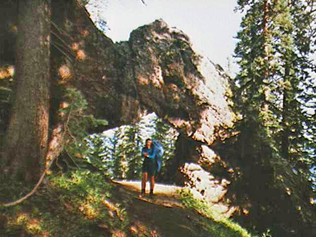
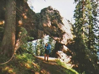
We left at Squaw Pass, which has trails down both sides of the Divide. The trail we chose, the Cimarrona, though shorter, starts with a 600' climb up to the Divide. So much for getting down to a lower elevation. The trail goes up and down and back and forth through spruce forest, endlessly. It took us three hours (six miles) to get under 10,000'. And we started at 11,200. By that time we had walked about 17 miles for the day, and it was past time to stop. We found a small perch near water. There were streams on both edges of the switchbacks, but they were hard to get at from the trail, so we just kept going. The few good campsites were up too high, and we don’t know if there is anything below us, so this little spot will have to do. We walked through a rock window. That was interesting. It was actually a pretty trail, switchbacking through the spruce, but we were eager to get lower, and it was frustrating not being able to descend low enough to do any good. Jim is really disappointed - he feels like his body betrayed him. I’m sorry we can’t do what we set out to do, but we’ve walked over 140 miles, that isn’t bad for 11 days. It has been beautiful, and difficult and worth it.
Jim: Enough - I’ve been developing symptoms of HAPE for the last several days. I thought I could hold on for another 3 days, but it ain’t gonna happen. When every breath is painful, regardless of up, down or level - it’s time to do something else. I’m operating on about one third lung capacity. That one third has become highly efficient at recovering what oxygen there is in the air - but it still leaves me a long way short of what I need to finish the next three days. We’ve actually accomplished our primary purpose for this trip (to complete the San Juan loop of the CDT) - but we’ll fail in our secondary purpose (to hike the entire Weminuche). We’ve camped right at 10000 ft on a small ledge next to the Cimaronna Trail. Still have a couple miles to drop another 1500 ft and get to the road tomorrow.
August 12 - Durango - 5.5 miles - total 149 miles
Jim: We got lucky with hitchhiking - again. Eric Peers picked us up and took us all the way to the Durango airport where we rented another car - well, sort of a car - it’s a Geo Metro. But it’ll get us where we’re going. Found a motel, got a good meal and a shower, did laundry and picked up our gear from Hermosa Court. Culture shock. What a difference from the last few days. Last night we slept perched on a small ledge beside the trail, tonight we’re in a bed with clean sheets. I’m not sure I like the transition all that much.
August 13 - Wednesday - South Fork
Ginny: We had a good day wandering around Southern Colorado and part of New Mexico. Yesterday was spent descending to the trailhead and then walking three miles on a dirt road past a couple of campgrounds, trying to hitch a ride to Pagosa Springs. We lucked out by getting a ride from a student who was chased out of the mountains by fear of bears. He ran into a horse packer who told him all sorts of stories. He gave us a ride 25 miles out to the highway, then 60 miles to Durango to the airport where we were able to rent a car. We ate lunch, showered, got our town gear back from the motel where we had left it before we took off for the mountains, wandered downtown Durango, did laundry, and finally collapsed. It was busy, but not much fun. Still, getting the ride was incredibly lucky. Today we explored places where the CDT passes through northern New Mexico and Southern Colorado, which involved a big circle drive through mountainous areas, high desert, ranch and farm country. We checked out Pagosa Springs (too touristy, and very spread out), down into Chama NM (another narrow gauge railroad town) – to a good Mexican lunch, to Alamosa (nice murals) to South Fork, to Creede It was smaller than I expected. We had dinner (banana splits) at an expensive ice cream parlor. The whole town was closed up at 5:00, presumably to play bingo in the Community Center in one of the mines. Then we drove to South Fork again. We had planned to camp, but it began to rain (surprise!), so we ended up in a motel in South Fork. It was a pretty peaceful wandering sort of day. Tomorrow is still up in the air, but today was nice. Relaxing, despite all the driving. (Jim drove.)
August 14 - Rock Lakes to Wolf Creek Radio Tower - two ways - 10 miles Total 159 miles
August 15- Friday - Durango again
Ginny: Yesterday we drove up to Wolf Creek Pass where we were supposed to end our hike. There’s a dirt road to a radio tower/lookout area that has a good trailhead that saved a 1000' climb to the CDT. From there we walked about five miles to the Divide beyond Rock Lakes. A thunderstorm developed (of course), so we turned around and headed back to the car amidst lightning, hail, rain, hail, thunder, hail - well it was a quick return and we didn’t even get all that wet since all the showers were brief. It was nice trail, mostly in spruce forest. A group of high school students, whom we met at the trailhead, had been working on it for four weeks, doing a lot of waterbars and filling in eroded spots. We saw fresh snow covering the mountains to the south. Although short, it was a nice hike. Jim’s cough returned, so we decided not to try any more hiking. Instead, today we drove west and north out of Durango on the scenic highway route - about 235 miles through desert, plateau, alpine mountain, old mines and other interesting terrain. It was really beautiful. I had forgotten how much red rock there is around here. We did a brief visit to Telluride (claustrophobic tourist glitz) and a much longer wander around Silverton (tourist shops and lots of hotels and restaurants, but wide dirt roads and a sleepier feel to it once the daily tourist trains have gone back to Durango.) We took lots of pictures as we drove around, taking our time. Ouray was a nice town too, but we didn’t spend any time in the shops there - another time maybe. We had a good, though tiring day. Now we’re back at the hotel, trying to decide between sleep and ice cream.
I’m not ready to go back home yet. Seeing all the beauty today reminded me of all the places we have yet to explore. I’ve done a lot of thinking about the reality of a CDT thruhike. Bailing out early might have meant an end to that dream, so I had to think about how much I wanted it, when faced with the reality of long distance hiking. Eleven days was exhausting, am I ready for 15 times that? But there is so much beauty out there. Fact is, I am happy on the trail, despite the rain and cold, sore ankles, no showers, perpetual pasta dinners, endless climbs, sunburn, puffing and panting and a too heavy pack. So much world out there - so little time to explore it all. It isn’t an easy life, but it is a fulfilling one.
Jim: Not much to say for the last couple days - it’s been a good time, although not what we came out here for. There’s an ambivalence in my attitude – I don’t know whether I love this country or hate it. The CDT was both more and less than I expected – more rain, more mud, more problems with the altitude, more beauty than I could absorb, less sunshine, gentler grades (Thank God). In some ways it scared me – it’s bigger, more awesome, rougher and more elemental than anything in the East. And more so than I ever imagined. And I ran into spiritual challenges of a sort that I haven’t had to face in a lot of years. But I also know that I’m addicted to it now. Both Ginny and I realized before we even got home that we had changed. For one thing we’re even closer to each other than we were before – and that’s hard to imagine. But there are other, less defineable changes in our attitude and outlook. Eventually we’ll figure them out, but it’ll take some time. Overall – it was a really good trip, I’m glad we did it – and the "Flight of the Spirit Eagle" is on course for ’99.
Home | Links
The Thruhiking Papers |
Created: 09 Jan 2004
Revised: 15 Oct 2016Copyright © 1997-2017 Spirit Eagle