|
 |
 |
 |
|
|
|
|
|
A Short Tour of the CDT in Southwestern Colorado
Introduction
Jim: Last spring Ginny and I had to decide what to do with our vacation this year - and the obvious answer was that we were going to hike - somewhere. But where? Glacier NP was a possibility, as were the John Muir Trail and the Sierra High Route. But when push came to shove - it had to be on the Continental Divide Trail (CDT). And it had to test our knowledge and abilities at altitude since I’ve never hiked at 10,000+ ft altitudes and it’s been 7 years since Ginny hiked the JMT. For a number of reasons, we finally settled on the San Juan loop of the CDT in Colorado. First, because it’s reputed to be one of the most scenic and beautiful parts of the CDT. Second because it involves distances and altitudes that would test us physically, mentally and emotionally. Third, because of time and weather constraints most CDT thruhikers skip this loop and take the Creede cut-off. And we recognize that we might end up with the same constraints and take the cutoff as well. This way we’ll have hiked this section of trail, even if it’s not in the same year as our thruhike. And fourth, this was a test run for our projected ‘99 CDT thruhike. We haven’t spent more than 4 days on the trail in over 5 years now - we needed to know how we’d deal with longer trail time - and with the CDT itself.
The original plan was to do the half-loop from San Luis Pass to Squaw Pass ( about 100 miles), but being thruhikers - that didn’t seem like enough distance for 2 weeks of hiking, so we added the 43 miles from Squaw Pass to Wolf Creek Pass so we could include the entire Weminuche Wilderness. That felt better. But then, between work, school, snowpack, mosquitos, weather, etc. we couldn’t schedule the time we wanted to go (the end of August), so we had to modify the time frame to the first 2 weeks in August. And then we realized that starting with high mileage days at 10,000 to 11,000 ft altitude wasn’t really smart - so we decided to start at North Pass (CO 114) and head south through the Cochetopa Hills. This would give us 2 extra days at 9,000 to 10,000 ft to acclimatize. Only we didn’t change our end point - we still intended to finish at Wolf Creek Pass - which increased our projected mileage to 185 miles. We thought we could do it, but couldn’t be sure with only 14 days hiking time.
One of the problems we encountered was transportation. There’s little if any public transportation in that part of Colorado that will do a hiker any good and the road distances are larger than life. So we went to the Internet and got very lucky by finding someone who was going to Colorado the day after we were and was willing to drive us to the trailhead. This also gave us an extra day for acclimatization. We flew into Durango and left our travelling clothes and the duffel bags that we used for the packs at the motel and rented a car for the drive to the trailhead.
Resupply was somewhat simpler - starting at North Pass, we planned 5 days to get to CO 149, which runs between Creed and Lake City. So we sent a mail drop to Lake City and planned to pick it up on Aug 5. That part worked very well. The second leg of the trip was to be 9 to 10 days into Wolf Creek Pass and then hitchhike into Durango. And most, but not all of that part worked as well.
The guidebook came from Jim Wolf at the Continental Divide Trail Society, with the late addition of the newly printed "Official Guidebook for the CDT in Colorado" which was published in cooperation with the Colorado-based Continental Divide Trail Association. Of the two, I personally prefer Jim Wolf’s book even though the version we had was an old one. A new one will be published this year. The CDTA book has a lot of good information on trailhead access, off-trail facilities and some alternate routes and is (mostly) accurate and clear. Most of the time we followed the "official" route. The official route follows Jim’s recommendations in most places. (His guidebooks predate the "official" trail by several years.) Occasionally Jim Wolf suggests bushwhacking instead of following trails or dirt roads, either to save pointless ups and downs or because the cross-country route is more scenic. To save time and effort, generally we chose to follow an existing trail rather than bushwhack. When we have a bit more confidence, we’ll probably be more willing to take chances. As a first encounter with the Rocky Mountains, we felt more secure following trails. Each of the guidebooks has unique information and I’d recommend using both of them in preparing for the CDT.
The maps we used were Trails Illustrated and USFS maps, with the addition of a couple of USGS topos. We used the USGS county (1:50,000) topos and they worked very well even though they don’t contain the detail of the USGS 7.5’ series. None of the maps are entirely accurate where specific trails are concerned, but they’re a necessity if you don’t want to spend a lot of time "wandering in the wilderness". The TI map #141 (Weminuche Wilderness) is topographic and easy to use, but is missing one section of trail and has another trail mislabelled as the CDT.
July 30 - Travel - Washington, D.C. to Durango, CO.
Jim: Yesterday was a rotten, no-good, very bad day - I got a dose of 24-hour stomach virus and we weren’t sure I’d make the plane this morning - but I did. It was a long flight to Albuquerque, then a 2-hour layover and a puddlejumper into Durango. Rented a car, dinner in town at the Old Tymers Cafe, a visit to the outfitter, then out to Hermosa Court where we crashed. Not much sleep - I had a little trouble adjusting to the altitude - heart palpitations, Cheyne-Stokes breathing, etc.
July 31 - Mesa Verde
Jim: A much better day - in spite of being locked out of the room first thing in the morning by a malfunctioning door lock. After breakfast and fuel stops we went to Mesa Verde and wandered through the Anasazi ruins. Lots of questions, not a lot of answers, a very precarious lifestyle - I’m very glad I didn’t live there ----- or did I? Back to Durango for dinner, a visit to the bookstore and a short wander through town before going back to the motel to pack the packs - they’re heavier than I care to think about. Then back to the airport to pick up Debra at 10:45 - a LONG day. We crashed again when we finally got back to the motel. My altitude problems are somewhat better after the mild exercise today, but Ginny still has a headache and has started taking Diamox.
August 1 - Campsite on Los Creek @ 9.4 miles Total 9.4
Ginny: We finally made it out on the trail - it was a bit iffy for a while. Jim had a horrible stomach virus the day before we were to leave, but fortunately he recovered quickly. Our flights were uneventful (the best kind) from Washington to Albuquerque to Durango. We wandered around the Albuquerque airport for a couple of hours, visiting bookstores and gift shops. It’s amazing how many interesting things there are to buy when you don’t want to buy anything. Our motel was ten miles out of town, a bit seedy but clean enough, and the owner is very friendly and willing to help us out when we return. Friendly service is worth a lot. We’re storing some things with him so we’ll have clean clothes when we return, and our duffle bags for our backpacks. He even offered to pick us up after we’ve finished hiking and to drive us to the airport when we’re ready to leave.
Thursday we ran errands and drove out to Mesa Verde to spend the afternoon. It was great. After a week of rain, the clouds finally lifted about noon so we had views over the mesas. We did all the free exhibits we could find (you have to sign up for the paid tours ahead of time and the line was too long), wandered around a lot and had a very enjoyable afternoon, thinking about the ancient ones. So much about their culture is unexplained. At 10:30 we drove out to the airport to pick up Debra, a woman from Atlanta we met through the Internet who was coming out to hike the Colorado Trail. She agreed to drive us up to the trailhead as she wants a few days of wandering around getting used to the altitude before she starts her hike. She has worked on the Colorado Trail and hiked most of it over the past ten years. I wish we’d had more time to acclimatize.
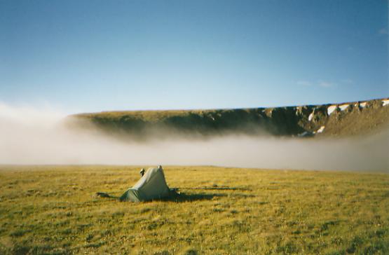
The drive to the trailhead was much longer than expected: about six hours with stops in Silverton for breakfast and for ice cream for lunch. It was a beautiful drive though. I oohed and aahhed all day as we wound our way through the mountains. We hit the trail at 2:00, walking along a green meadow near the highway then up a side creek, over a mountain, down to another beautiful meadow and another creek. Flowers are abundant: lupine, bluebells, gentians, asters, sunflowers, paintbrush, etc. Some I know, many I don’t. The skies were blue in the morning, threatening in the afternoon, but so far we have avoided rain. The altitude has gotten to me, badly. Jim is just breathing hard, but I’ve had the full gamut: headache, heavy breathing, tiredness, etc. Climbing a small hill, I feel like I’m running a marathon. I’ve started taking Diamox, which should help. It made the headache go away anyway. Getting energy may take a few more days. We ended up hiking 9 miles to a hill above a stream and a stock pond. It is in sight of two other campers. We’ll find out who they are when I get the energy to climb their hill. I am very happy, despite my physical problems. It is so very beautiful.
Jim: The alarm went off at 0500, but we didn’t get up until 0630. Packed the car, picked up Debra and drove to Silverton for breakfast at the Brown Bear Cafe. Beautiful drive through the Uncompaghre, then down onto the plains to Montrose. East to Gunnison and a stop at the Sundae Shop for lunch. Got gas and film and then out to CO 114. Found the trailhead, but went on to Buffalo Creek Campground to use the outhouse, change into boots, and do a final check on the packs. Met the campground host - she’s 72 and a delight to talk to. Wonderful attitude.
Back to the trailhead where we said goodbye to Debra, took a couple pictures and finally got on the trail at 2 PM. The first half mile was a gentle downhill followed by a 3-mile uphill and then a 0.3 mile bitchkitty of a climb to the top of the first ridge. I got a little lightheaded, but no real breathing problems other than sounding like a steam engine. A long 3-mile downhill followed by a mile uphill, then we followed Los Creek for a mile - 9.4 for the day. Not bad for a 2 PM start and 9600+ ft altitude all day. We camped at a water impoundment - lots of mosquitoes. Another couple is camped across the way but we haven’t met them yet. Hung the food bags up the hill since we’re still below treeline.
August 2 - campsite on Cochetopa Creek - 13.4 miles, total 22.8 miles
Ginny: Lunch break near a stock pond along Van Tassell Gulch - tired but happy. Jim’s feet are badly blistered. We’re not hungry but need to get rid of the excess food. I overpacked. The two campers last night were two women out doing the whole Colorado Trail. They are taking their time and have met a lot of other CT hikers, including several former AT hikers. They have had a lot of rain this past week and were happy to be doing a short day to meet friends today.
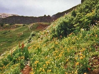
The hike has been beautiful along the edge of Cochetopa Park - miles and miles of open meadows covered with grass, rabbit bush, wildflowers and cows. Cochetopa Dome to the north and Sawtooth to the west dominate, although there were occasional glimpses of snowy peaks farther south and north. To the south are rolling hills covered with aspen, firs and spruce. We had a close encounter with an unhappy herd of cows at Manchego Creek. We must have scared them - they bawled for ten minutes. We saw one deer and one chipmunk, but no other wildlife except occasional birds and lots of flies and mosquitos. The clouds moved in by 11:00, but we've had no rain so far (12:15). We’ll get water here and keep on climbing. Today has been mostly little ups and downs (200' up and 200' down), but still we puff and pant. So far today has all been on old roads - occasionally used evidently. We ran into two jeeps on the trail today. One was driven by an older couple who were sectioning the Colorado Trail. They rapidly lost interest in us when they found out we were hikiing the CDT rather than the Colorado Trail.
Later: campsite on a bench above Cochetopa Creek. Very dark clouds and occasional sprinkles. We moved our gear into the tent, but not ourselves yet. The hike along Cochetopa Creek was lovely. There were lots of beaver dams and lodges. We saw a couple of fishermen too. We stopped for a long overdue water break and saw a moose in the willows below us. We stared at each other for quite a while before Jim and I moved on and let him get back to feeding. We stopped a little earlier than we had planned, but Jim and I were both tired and ready for a cold bath. It was wonderful. So far the trail has been good and easy to follow. There are few trail markers — about one per mile — but the guidebook description is good enough to follow. The occasional markers are mostly reassurance, especially when the map and the trail don’t agree. We ran into one section yesterday where the maps lied outright. It was obvious where the trail went (we were following a dirt road at the time.) Jim Wolf’s description called for a bushwhack and he merely mentioned that we should ignore the new logging roads through the section. The new guidebook told us to follow the road, so we did as it was easier than trying to bushwhack through new growth, and fortunately it worked.
Jim: Alarm at 0500 again, but we didn’t get up until 0645. Just can’t seem to get in sync with my electronic rooster so I may have to reset it. Breakfast, pump water, pack and out at 0815. Finally met the neighbors - Nancy and Twigg (?). They’re thruhiking the Colorado Trail - slowly - about 7 miles per day average - they’re in no hurry. We crossed Cochetopa Park - more up and down than yesterday and lots of road walking (all dirt roads). Lunch at Van Tassel Gulch (and contrary to the latest, up-to-date guidebook - it’s NOT dry). We had a long climb over the ridge then down into Cochetopa Creek where we saw lots of beaver dams and a moose. I expected elk, but the moose came as a surprise. Camped at 10,100 ft on a bench above the creek. Total 13.3 miles for the day. It started raining right after we finished dinner so we were in the tent early again. Hung the food again - we’re still below treeline. This was my day for problems - no energy, hard to breathe, headache, slow. I may have to start on the Diamox tomorrow but I hope not. But we climb tomorrow - 12,000+ ft tomorrow.
Blazing is different here - only at turns or junctions or across long stretches of meadow. And that’s the Colorado Trail markings. We’ve only seen a couple CDT markers. There are miles long stretches with no indication whatever as to which trail we’re on. Map and compass skills are an absolute necessity.
Water - because something’s labelled a creek, draw, gulch, whatever doesn’t mean there’s water there. There are long stretches without water so we pump as much as we can every chance we get. We’re each carrying 2 quarts of water. Because of the altitude, we are trying to drink every chance we get. Every time we stop for breath, which is often, we get out the water bottles.
August 3 - campsite on Cochetopa Creek - 10.5 miles - total 33.2 miles
Ginny: It ended up raining on us after all just as we were finishing up dinner. We took the pudding into the tent and waited for it to stop. When it did, we bearbagged the food and went to bed about 8:00. It rained for several hours more, gently but persistently. When we awoke it was cloudy, but dry, fortunately. Still we ended up doing a short day. It began to rain while we were having lunch. There was thunder but not too close. Still, the idea of climbing above treeline didnt appeal, especially when we found a pretty little campsite in a spruce grove, nearly dry because it was protected by the trees. Were next to a lovely meadow, and look out on an interesting craggy rock with some nearby basalt columns (like Devils Postpile) and what may be a grizzly cave in a snowfield a cross the way. There were lots of flowers today: two kinds of gentians, monkshood, elephant head, etc. The sun came out while we were setting up camp so we spread all our stuff out to dry. The tent was almost dry in just a few minutes. I feel a little wimpy for stopping early, but the site was a good one and we still have a good climb up to the Divide. Besides, its better to camp low - well 11,500 isnt exactly low, but its not as high as we were planning to go. Except for our breathing and slowness the altitude isnt hurting us too badly. No appetite though, which means well end up with way too much food. No animals today, though we passed dozens of beaver dams and lodges. We saw moose and deer tracks all over. Lots of people. There was a family on horseback that carried a little black and white dog in one of the saddle bags. Another group was out fishing and camping, and we passed a group of tents in the rain. This may be a wilderness, but it isnt a solitary one. We passed a trailhead on a jeep road that had six or seven cars. All day we have followed the trail above Cochetopa Creek. Its a long one. We forded it once, but mostly stayed well back from it. All the creeks are lined with dense willow, making access difficult. Its a beautiful peaceful day.
Jim: Up at 0700, on the trail at 0830. We seem to be particularly slow about getting out in the morning. It rained again last night so Im carrying a wet tent again. Lots of beaver dams in the 4 miles to the Eddiesville trailhead. Watched a couple of beaver working in one of the ponds and took some pictures, but I dont expect much of them - they were too far away. Continued along the Cochetopa - met and passed a group that was headed upstream to do some fishing. Then we stopped for lunch on top of their campsite at the entrance to Diablo Canyon. They were some put out about it until they found out that we werent staying. Then the horse group showed up - not friendly at all. We intended to go to the headwaters of the Cochetopa, right up under San Luis Pass, but we got waylaid by this beautiful c ampsite and some sunshine to dry out our gear - and what I still believe was a grizzly den in the snowpack about 500 ft. up the other side of the creek. I could feel the power even from where we were camped. We definitely hung the food tonight. Ginny took a couple pictures of Organ Mt before the clouds finally closed in and it started to rain again. 10.5 miles for the day, campsite at 11500 ft.
August 4 - campsite near Mineral Creek Trail junction - 11.8 miles - Total 45.1

Ginny: Lunch at San Luis Pass. It rained, gently, all night from 6 PM to about 7:30 am. We got up just as it stopped, but had clouds and occasional drips all morning. Still it was a good morning. Despite mist and fog, the views are spectacular. We’ve gone over three saddles, each with a different view. Kick ass climbs though. We’re slow. We face another 900' climb this afternoon and are in no hurry to move, despite the rain. Beautiful flowers are everywhere. We saw our first columbine at 12,000', yellow and pink paintbrush, tiny alpine flowers, larkspur, monkshood, elephant heads, white purple and yellow daisies, asters, sunflowers, clover, etc.
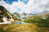
Later: Rain forced us off and chased us 800' up a saddle. A few sprinkles, nothing serious. Several more saddles led us from one glacial cirque to the next. Beautiful but exhausting. We finally called it a day at 12 miles on a lovely ledge overlooking West Mineral Creek Basin. There’s water from a snowfield just above us and lots of deer and elk tracks across the meadow. Big bad black clouds are moving in again. But all day we’ve alternated sunshine and showers. It never got too bad. I would have liked more sunshine, especially for the views. We couldn’t see very far with the moisture in the air. We saw what looked like a herd of deer across the way this morning, and a grey grouse and a beautiful brown and white moth, some marmots, a pica, and lots of ground squirrels. We met two groups going the other way and saw a couple of four-wheelers at San Luis Pass and a helicopter that buzzed our campsite last night. Not quite a solitary experience, but wilderness enough. We had no trouble following the trail, though the tracks fade out on the really alpine terrain. There are posts across the open areas and clear tread through the trees. We reluctantly passed up a lovely campsite three miles back near a beaver pond. It was in the spruce, under some awesome cliffs, but too early in the day. There was so much beauty. At one point I was so filled with joy and gratitude and awe that I started to cry. Jim hugged me and shared the feelings - though not the tears. It is so magnificent!
Jim: A long day - 11.8 miles - and I’m slower than I think I should be. The grades aren’t that bad - if this were 6,000 ft lower we’d probably cruise. But it’s not - and we’re not. It was cloudy most of the day, with occasional thunderstorms. Hadn’t planned on this - I expected the late afternoon thunderstorms, but the 24 hour rains have come as a surprise. I think they’ve also surprised some native Coloradans. The terrain changed drastically at San Luis Pass. In the Cochetopa the terrain was somewhat relatable to some of the Eastern trails. But at San Luis Pass we entered the high country very suddenly and nothing in my previous experience compares to this – not even the Whites. It’s beautiful, it’s wonderful, it’s awesome and it’s a little scary. Finally camped just under the Divide in a small cirque at 12,500 ft. It has a small stream that’s fed by the snowpack. It also came with a built-in thunderstorm that dropped a lightning strike on the ridge about 100 yards from the tent. That’ll start your heart - or stop it!!
August 5- Lake City - Bed and Breakfast - 8.4 miles - Total 53.3 miles
Ginny: A short day into Lake City. Last night it began to rain just as we finished up dinner. It turned into a real thunder boomer. One hit the ridge about 300 yards away. Scared me! It didn’t last long - but was intense while it lasted. The fact that we were so close to the ridge and above treeline didn’t help. We woke up to dense fog/cloud and decided to move on rather than cook breakfast in the cold and damp. I have no idea what the terrain was like at first. We climbed from our campsite at 12,500' up an open grassy ridge to about 13,100'. It wasn’t easy finding the posts in the fog. We were even more worried about losing each other. Ten yards was out of sight, so we hiked close together. We climbed for a couple of miles, then went around a glacial cirque, then out on to the open mesa. The fog lifted and we could see miles and miles of rolling grasslands. We noticed a herd of elk off in the distance, but they ran off at the sound of my voice. We finally had breakfast - a few cookies - at about 9:30 as we sat near a big pond and tried to figure out where the trail goes.
It was rather obscure through there. In the really high alpine environment, the trail disappears. When the posts are sparse, it can get difficult, even with good directions in the guidebook. (And the guidebook told us to take a bearing of 290· - which would have led us off in the wrong direction and up a steep hill besides. We followed the posts instead, and just hoped that the stock driveway and the trail were still the same through there. The old stock driveway has posts marking the sides as well as the middle of a wide corridor - sometimes it coincides with the CDT, sometimes not.)
The sun came out for a few minutes at about 11:00, just before we dropped off the edge of the mesa. Actually, we descended a barren rocky draw for a short way, then finished the descent through a lovely spruce forest. We reached the highway at Spring Creek Pass and immediately got a ride with a very nice family from Texas. Bernie Adair was an engineer with Hewlett Packard, out with his daughter, son-in-law and two granddaughters. We decided to stay the night at a nice B&B, the Cinnamon Inn, so the afternoon was spent eating lunch, going to the post office, doing laundry, emptying our packs and reorganizing things, shipping back 12 lbs. of stuff (we aren’t eating as much as expected. We carried too much food for the first part of the trip. I hate forcing myself to eat just to lighten my load - and Jim won’t eat if he’s not hungry.) The owner of the B&B will drive us up the mountain in the morning, so we should be able to get a decent start in the morning. We’re both exhausted. I want a shower and bed, then maybe dinner later - if we get hungry again. Right now it doesn’t interest me much, but we’ll see how I feel after the shower. (Turned out the shower attachment didn’t work, so I reluctantly took a long soaking bath. I was so dirty, I hated to sit in a tub in my own dirt. Instead I took two baths - one to get the top layer off and another to feel clean.) Lake City is a nice small town - touristy but not too bad. The setting helps - nestled in the mountains the way it is. We had a few small rain showers as we wandered around but nothing heavy. Mostly it was just cloudy.
Jim: I re-learned a lesson today - don’t trust someone else’s directions. The "Official" guidebook directions would have put us someplace in Never-Never Land. If we’d blindly followed the guidebook, we’d still be out there on Snow Mesa trying to find the trail. Gotta know how to read a map - and use some common sense. There was a tremendous contrast in coming off the Mesa after 2 days above treeline and descending into the trees again. Grey skies have become the norm - and a wet tent has become my constant companion - sunshine is the exception. We skipped breakfast, grabbed some cookies during a water break, and got to the road by noon - just in time to stick out my thumb and get a ride all the way into Lake City. Then we got to do the walking tour of Lake City for the rest of the day - lunch, post office, laundry, back to the post office, grocery, dinner, outfitters (for fuel), etc. We got in bed late - and, as usual, didn’t sleep well. We never sleep well in town - why do we bother?
Home | Links
The Thruhiking Papers |
Created: Fri, 09 Jan 2004
Revised: 15 Oct 2016Copyright © 1997-2017 Spirit Eagle