 |
 |
 |
 |
 |
 |
|
|
|
|
|
|
August 2003
Canadian Barbeque
Jasper, Yoho and Lake Louise
Sunday, August 10 - Mt. Kerkeslin Campsite - 5 miles on the Bald Hills Trail
Our plans changed, again. After breakfast we headed north toward Willmore, but ended up getting lost in a maze of unmarked logging roads. Our map was 13 years old and there are a lot of new logging areas and logging roads since it was created. We turned around when the road we were following deteriorated to the point that we were worried about our rental car (dents are bad enough, getting stuck would be worse) and followed our noses back out to the highway on new roads past clear-cuts and working logging operations. We drove to a nearby park and were told that another road 30 km north is a much better entry to the Wilderness Area. It even had signs, which the roads we were following didn't have. Because we were worried about the car, the thought of driving another 30 miles on rough dirt roads didn't appeal, and somehow we both had a bad feeling about this jaunt, so we turned around and went back to Hinton and then on to Jasper.
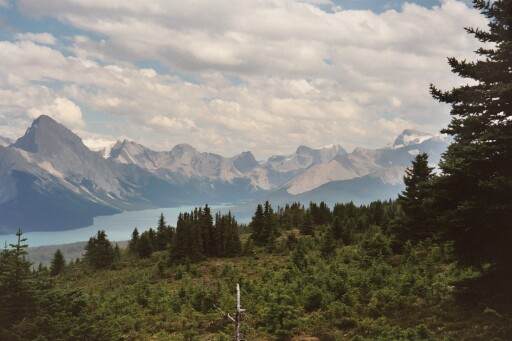
Since we now had lots of time, we turned up Malign Canyon Road which is a 40 mile paved road leading to two large lakes and several hiking trails. A couple of the trails were closed, either because of a recent fire or because of grizzly activity. The mountains there are different, stark whitish gray rocky cliffs with no vegetation on top. Opal Mountain is a reddish color. In the Tonquin Valley, the mountains were very dark, black and red volcanic looking, rather than light granite type peaks.
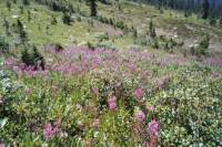
Although it was already 3:00 by the time we reached the end of the road at Maligne Lake, we set off on a short five to six mile hike up to the Bald Hills above the lake, following a steep fire road. It began to rain about ten minutes into our hike, but the thunderstorm passed through in about half an hour. The view from the top was beautiful, with snowy peaks, steep mountains, distant lakes and another approaching thunderstorm. The trail continued up one of the big bald knobs, but between feeling tired at the climb we had already done and seeing the steep trail ahead, and the black clouds approaching, we decided it would be better to head downhill. The rain hit just as we reached the car. We drove slowly, with various stops for wildlife, back to Jasper, where we ate dinner and then headed south on the nearly empty highway to a small campground by a wide river. There are very few people camped here. While the morning was very cloudy and hazy, after the rains this afternoon it cleared up nicely, so our evening drive was beautiful. It started raining, again, soon after we arrived, but since it's almost dark, we didn't mind. We were ready for bed. Last night I was so worried about the trip to Willmore I couldn't sleep much. Tonight should be better.
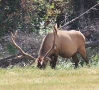
Despite the complete change in plans and a day spent mostly driving, it was a good day. We saw lots of wildlife: a mama black bear with cub, two mule deer, an elk buck in full antler regalia, plus two female elks wandering beside the road, a moose and her calf, five mountain sheep, a heron, two grouse and a hawk. We passed through a wolf area, but didn't see any. Again, all our sightings were on the road. What happens is one car sees an animal and stops to take pictures so everyone else stops to see what they are looking at. Some people get way too close to the animals trying to get a good picture. I won't do that. Either the picture from the car window works, or it doesn't. I'm not going to put myself in danger just to snap a photo of a bear. I've seen bears before.

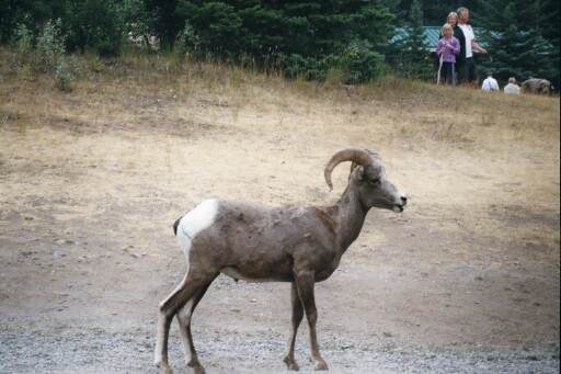
Jim: So - back to Jasper - fires were still raging, and in fact, according to the local paper, there were over 200 fires in Alberta and British Columbia at that time. Which, of course, meant no backcountry permits except for those who already had reservations. We didn't. Sooo - we changed direction again and decided to try Willmore Wilderness Park, which is northeast of Jasper. No fires, no permits required, supposedly lots of horses, no camping restrictions - and we couldn't find anybody who knew anything about it. Finally found a map (an old map) and hit the Internet Cafe to look it up on the Web - then drove to Hinton and got groceries, a motel room, a meal and a shower. First shower in a week - it was wonderful - and necessary if we were ever to emerge into civilization again. On the way to Hinton, we passed the Syncline fire - it was mostly out, but it was a HUGE area. I can see why they closed some of the trails on the other side of the ridge. On the edge of the burn area, along the road, we saw more mountain sheep at another salt lick - and then a black bear. Took the obligatory pictures, of course.
Willmore - well, we finally found the entrance to the area - after some 60 miles of wandering along highways and logging roads. At one time, we looked at a logging road we KNEW would lead to the trailhead and decided that the rental car just wasn't up to that kind of bushwhack. We finally found our way out of the logging roads (there are a LOT of them, mostly not on the map) and wandered into a local Provincial Park where the ranger knew about Willmore - and even had a map. But she'd never been back there either. By this time, both Ginny and I were getting the idea that we just weren't supposed to do this particular trip. We were both getting "bad vibes" about it and we've learned to pay attention when that happens. So, being stubborn, I insisted that we at least drive far enough to find the entrance road so we'd know where it was when we come back next time. I should know better by now - the ranger had said it was 4 or 5 km up the road. It turned out to be over 30 km. Enough -- we turned around and headed back to Jasper. Stopped at Maligne Lake on the way, did a short (5 mile, 2000 ft eg) dayhike in a brief thunderstorm, saw our moose on the way out the 30 mile entrance road, got a meal and a campsite and went to see a program by one of the Canadian grizzly research program directors. Funny - he's doing the same kind of research that we started doing in the States 30+ years ago using satellite tracking. Really funny thing is that his conclusions don't support all the popular doctrine about grizzly behavior. But they do support the conclusions that were reached 30 years ago by the programs I was involved with then.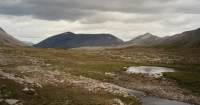
Monday, August 11 - 14 miles at Wilcox Pass and Nigel Pass, Waterfowl Campground
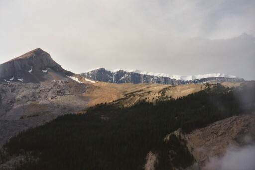
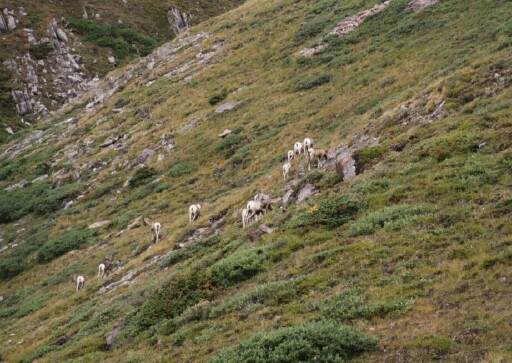
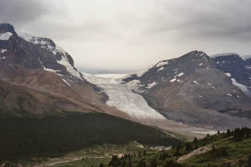
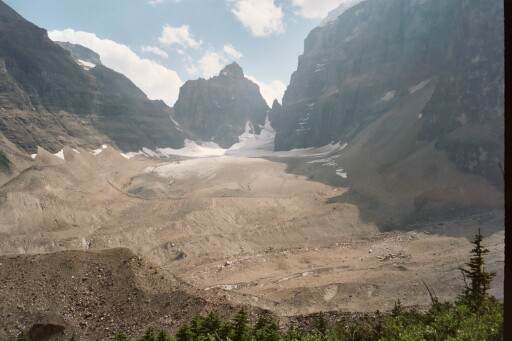
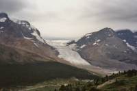
We did two day hikes today, both beautiful. The first was a short hike, a five mile round trip to Wilcox Pass where we had beautiful views across the valley of the Athabasca Glacier and the Columbia Icefield. We started climbing in forest, but soon rose above treeline. It rained on the way up, and the clouds were very low when we started our climb, but soon it cleared up and we had nice views. Near the top we spotted a herd of about 12 mountain sheep. The upper valley was flat and open, just rocks and alpine plants. We spotted more mountain sheep grazing nearby. A golden eagle soared overhead. Happiness is. We met lots of people on the way down and saw one more lone sheep posing on the ridgeline.
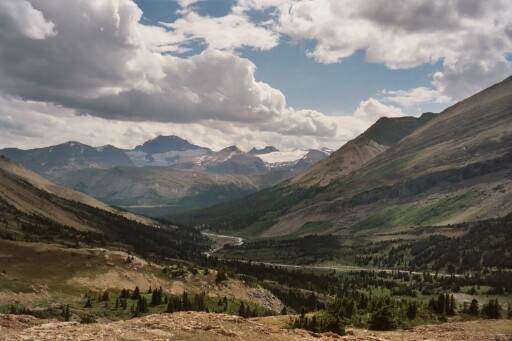
Lunch was at a roadside picnic area a few miles down the road, and then we headed up another nearby valley to Nigel Pass. It was a nice hike, partly in spruce forest and partly in open meadows. It was all quite beautiful. That hike was over nine miles round trip, and an easy walk -- not as steep as Wilcox Pass though there was some climbing at the far end near the pass. The mountains are different colors, white red, yellow and gray. Some had glaciers, most didn't. But somehow it was all absolutely beautiful. We followed a river and looked for wildlife below, but only saw ground squirrels and a falcon. Earlier, on the highway, we passed a couple of bull elk, but that was it for the day.
We finished our second hike at around 5:30, just after the afternoon thundershower hit. We were only five minutes from the car, so we got damp, but not soaked. Then we drove down the parkway and admired the views. It was much clearer than the last time we passed through and the mountains were really awesome. In an hour we found a campground - nearly full but not quite. We grabbed the first open site we found. It's close to the highway, so noisy, but that usually eases at dark. We're both exhausted after all of our walking, so it shouldn't keep us awake regardless.

Jim: Today we started our "dayhike" phase - drove south to the Athabasca Glacier and climbed to Wilcox Pass in a light rain - but still got some really good views of the glacier. And some pictures of a couple herds of mountain sheep. One herd was females and young, the other was the males. And then there was a lone male on the ridgeline as we came down out of the pass. Hordes of people up there, too. That's been the "fly in the ointment" this trip - and continued to be right up until we left. After Wilcox Pass, we drove to the Nigel Pass trailhead and walked the 6 miles in to Nigel Pass - beautiful country, but still too many people. By this time, I was tired and sweaty, so we drove to Yoho National Park, got a campsite - and a shower (sorta). Ok - I got wet and soapy - but it wasn't a great shower. And you're not expected to picture the "wet and soapy" part.
Tuesday, August 12 - Yoho Campground 12 miles on the Iceline Trail
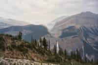
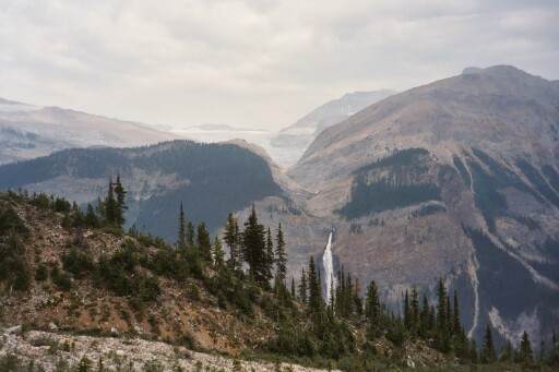
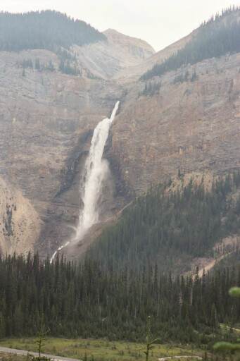
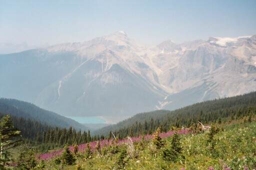
More changes, but all in all, a good day. We woke to clear blue skies, but as we approached Lake Louise that changed to a smoky haze. We stopped in town at the Visitors' Center to ask about trail and road conditions and to get some cash. It turns out the trail we planned to hike today through Paradise Valley is restricted to groups of six or more due to bear activity. We waited a while at the trailhead, but no one drove up, so we turned around and went to Yoho National Park, about 30 km west of Lake Louise. There we started a hike at beautiful Takkagaw Falls, at 1250' one of Canada's longest and most beautiful waterfalls. We climbed (and climbed) up to the Iceline Trail which follows the base of several glaciers high above the valley. We crossed moraines and eskers and drumlins - lots of glacial remnants. There were lots of people out hiking, of course. It was hazy and very cloudy, but we only felt a couple of sprinkles. The views were interesting despite the haze. The Kootenay fires are just south of here, hence the lack of visibility. About six miles into the loop, we descended into old spruce forest, which continued for the next seven miles. We passed a couple of waterfalls. Laughing Falls was the best one. There were flowers both up high and down below: mostly yellow or orange paintbrush, purple fireweed and blue harebells, but also some purple asters and white daisies, blue larkspur and white Queen Anne's lace as well. The upper area was very barren - just rocks and ice, but the lower section was very green, mossy and lush. It was a long day, but a good one. We didn't start our hike until 12:30 and then went 13 miles. Fortunately we had stopped at the campground on the way up to reserve a spot so we had a place to sleep. All the nearby campgrounds are full tonight. We went out to dinner at a lodge nearby as we were very hungry and too tired to cook. A couple of beers with steak and lasagna and deep dish apple pie - aah, happiness! We took a shower at the campground, but the water was cold. That was a disappointment!

Jim: We drove up the road to Takakkaw Falls, which is also the trailhead for the Iceline Trail - a 13 mile loop that climbs 2100 feet, then follows along the foot of the Emerald Glacier and loops back through the Little Yoho Valley. For those who love "above-treeline" hiking, most all of these hikes are terrific. The trails climb like a banshee to get you above treeline and then you wander for miles through scree and talus fields with views like I haven't seen since last year in the Absaroka-Beartooths.
Wednesday, August 13 - Nine miles on the Plain of Six Glaciers - Yoho C.G.
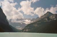
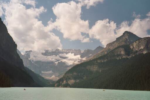
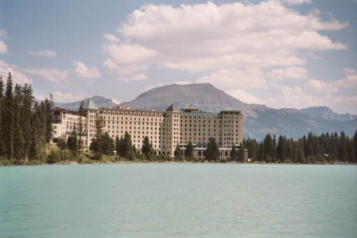
We were really sore and tired, so decided to have an easier day today - well, sort of. We slept late, then drove back to Lake Louise where we played tourist a bit by driving to two lakes: Moraine Lake in the Valley of the Ten Peaks and then Lake Louise itself. Both were very crowded, with busloads of tourists. We only took pictures at Lake Moraine, since the more interesting trails out of there require groups six or more people to reduce the chance of bear problems, but at Lake Louise we took a hike that extended itself to a longer loop.
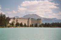
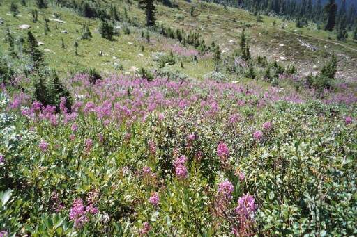
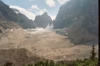
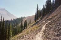
First we walked along the lake on paved trail, past the enormous resort, The Chateau, and some small cliffs covered with roped climbers, then we climbed to the Plain of the Six Glaciers and past the teahouse to a viewpoint at the end of the valley, where we were right above and next to a couple of glaciers. On our return we ran into a very slow moving horse parade and decided to head uphill to Mirror Lake instead of following the horses for the next few miles. The alternate route was much less populated but a bit longer than the paved trail by the lake. Losing the crowds, and especially the horses, was worth the extra climbing. There was no view in Mirror Lake, though we could see the huge rock formation known as the beehive above us. Not being able to hike in the Moraine Valley is frustrating because so many trails are closed by the fires, and it concentrates use in the few trails that are open. I think the trails around Lake Louise are always crowded though - it is so picturesque and easy to get to. Despite the hordes, today was nice hiking. The waters were glacial blue, the mountains steep and dramatic, the glaciers icy (but dirty) and full of interesting crevasses. I enjoy the walks through the spruce forests. One area had a whole meadow of fireweed in hot pink bloom - lovely. We saw no wildlife aside from ground squirrels and red squirrels but then, that's not surprising.
On our return to Yoho Campground, we ended up stopping at West Louise Lodge again for hamburgers and beer in the bar. (It was better than Liptons!) We're still trying to figure out how we are going to spend the next three days. We would like to go backpacking, but Lake O'Hara in Yoho is fully reserved, and Banff isn't allowing any new backcountry reservations because of the high fire danger. Only Jasper and Mt. Robson are allowing backcountry permits, and we're too far from the town of Jasper to get a permit now. We're happy with our hiking, but we're definitely starting to get tired.
Jim: Today we went to Lake Louise - we'd skipped Lake Louise on the way north because of the smoke. But this time we were serious - sorta - we did the "tourist thing" and took the Plain of Six Glaciers trail directly from the Lake Louise Lodge. Lodge? It's a bloody zoo - a great monstrous monolith of a hotel with thousands of people - all of them trying to prove how "outdoorsy" they are. Oh well - once we got up into the bowl with the glaciers the views were great. And the crowds thinned out a little. But then we got to follow the horses back down toward the Lodge - so we took off on the Mirror Lake trail. This was my day to bitch - about the unexpected climbs and about how tired I was and --- well, other things. It wasn't a pretty sight. So -- back to Yoho to camp for one more night.
Thursday, August 13, 10.6 miles to Boulder Pass - Lake Louise CG
Since we can't go backpacking, we decided to dayhike one of the areas we would have liked to backpack - the Skoki Valley. It is near Lake Louise, across the valley behind the ski area. It was a beautiful clear morning, with lovely views back toward Lake Louise, but somehow we managed to leave the camera behind and couldn't take any pictures of the beautiful mountains and meadows.
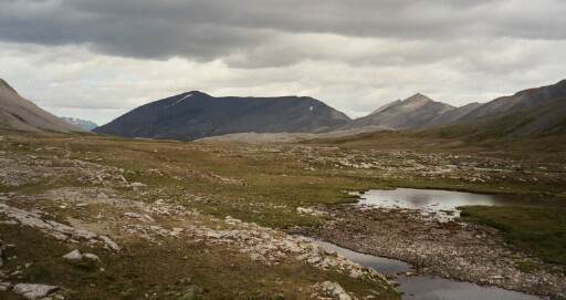
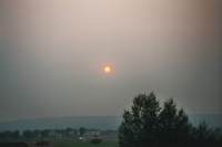
The first few miles we climbed steeply up a gravel road. It is closed to traffic, except for the ski resort employees on business, supposedly. At a chairlift, we left the dusty road and headed for the high country. It was beautiful with steep gray and orange mountains and lush green meadows. We climbed to a small pass above blue Ptarmigan Lake where we ate lunch and enjoyed the views. It was gorgeous! Then we turned around and walked back. We kept our eyes open for bears, since some hikers we met had seen a grizzly two days before in the area, but we weren't as lucky. We felt their presence, but they weren't making themselves visible. Lots of cars passed us on the way down, despite the restrictions, so we were very dusty and ready for a hot shower at the end of the hike. This time, the water at the campground was actually hot. Heaven! All in all, another good day -- except that there is a huge smoky cloud above town. I'm not sure where it is coming from, south or west, but it is very ominous, looming above the mountains, huge and dark.

Just as we were finishing our pasta dinner at the picnic table, a woman drove by and asked, "Would you like some free ice cream?" Our response was predictable. It seems there was a big power outage and the resort's freezer wasn't working, so they decided to give away their popsicles and ice cream sandwiches. That was a nice unexpected bit of trail magic. This campground is different - they have surrounded the tent camping area (separate from the area with hookups for RVs) with an electric fence to keep the bears out. Seems that one of the largest campgrounds in Banff had to close because there were too many grizzlies wandering through the tenting area, so they are trying this to see if they will learn to stay away. Must be an expensive project, but worth it, I would think, if it works. The Banff campground had 450 sites out of service, which is not good at the height of the tourist season. This campground is also larger and busier than the one at Yoho. Hot water is one benefit to being less remote. We're also farther from the highway and I hope there will be less rail traffic too. Yoho was next to a very busy rail line - trains went through every half hour or so. They need special spiral tunnels to ascend/descend the pass. I would have liked to see a train actually using them. This site is also closer to bathrooms, which I do appreciate, especially first thing in the morning. Tonight we'll go see a presentation on grizzlies at the campground theater. We're both very tired, even though we didn't hike all that far. I think the uncertainty/disappointment at not being able to hike where we had hoped took a toll this morning. I understand why they want to limit use in the backcountry with the fire danger so high, but it is still disappointing to be told that everything is closed because of fires and bears when we have come this far to hike.
Jim: Today we moved camp to the Lake Louise campground and tried to get a backcountry permit for the Skoki Valley. Well, that was a disaster - they're not issuing ANY backcountry permits anywhere in Banff Park. And some of the trails are closed due to bear activity. The Paradise Valley trail was open, but the requirement was that a minimum of 6 hikers go together - and stay in a tight group. We were only short by 4 hikers, so we decided to do a dayhike into the Skoki Valley - at least as far as Boulder Pass. It was only an 11 mile round trip, but it was also a nasty little climb along a fire road for a while. When we got to the pass, we had lunch at Ptarmigan Lake, watched the pikas and horses for awhile, tested the trail to Redoubt Lake (it was solid talus - and we didn't care that much), then followed the horses down the trail and back to Lake Louise, the campground, a shower and another (different) grizzly presentation by a Park interpretive ranger. It was a beautiful clear morning, with incredible views of the snow-capped mountains above Lake Louise and the Skoki Valley, and of course we left the camera in the car. We had a beautiful lunch spot, and an easy day, but portentous. As we came down off the ridge, we could look across the valley and see billows of smoke coming from the direction of the Kootenay fire. As one of the rangers said - "Kootenay is on fire". And she meant the whole Park.
Friday, August 15 - Lake Louise Campground - 12.2 miles on the Emerald Lake Triangle
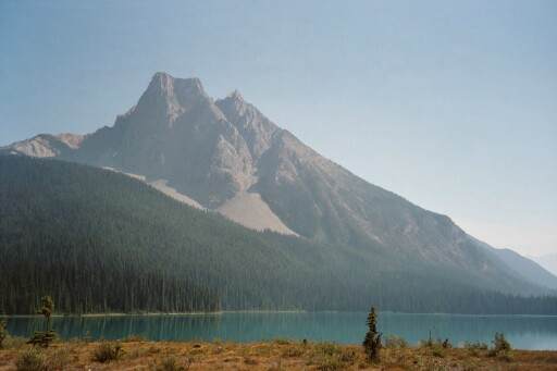
Our final hike was a good one, but also a hard one. The smoky haze lingers, making it hard to see very far and affecting our breathing. We drove back to Yoho for our last hike, a 12 mile loop above Emerald Lake. We saw fewer people than usual; in fact, we had the trail to ourselves for the first three hours as we switchbacked steeply up through cedar and spruce forest 3000' to Burgess Pass. Then we were out in the open for a while, slabbing under a famous fossil shale bed (off limits to hikers unless accompanied by a guide). We saw a couple of nice waterfalls, including a really long one off Emerald Glacier. The descent was steep, hot and quite nasty over loose scree. I overheated a bit, even though we were carrying lots of water. At the bottom we crossed about a mile of glacial gravel on flats with several small glacial streams. They built bog bridges that went on for long stretches over the gravel and streams; it was easier than walking on the soft and shifting rocks. The lake was very green at the end of the day; it seemed more turquoise this morning.
I was sorry about the smoke haze, but not as upset as I was two weeks ago when we arrived. I've seen the beauty, even if we won't have a lot of good photos to commemorate our hikes. Yesterday was so clear and beautiful, it was really frustrating to find that we had left the camera in the car. Today we had the camera, but the towering peaks all vanished in the haze. Oh well. Despite the fires and many restrictions, this has been a really good vacation. We are both exhausted, but happy.
We finished by having dinner in the tiny village of Field at the Truffled Pig, a tiny cafe with a barbeque and a few outside tables. I had a steak and Jim ate an elk burger. Field has lots of B&B's and one nice lodge but only two restaurants, one at the lodge and this one that doubles as a grocery store. We came back to Lake Louise and a cold shower (the difference between taking your shower at 5:00 and taking it at 7:30, I guess - the hot water gets used up.) We're too tired for the evening show at the campground tonight, though I enjoyed last night's performance. It is noisy tonight, but I'm so tired, I don't think I'll care.
Jim: Our last hiking day - wasn't so easy. We went back to Yoho Park to Emerald Lake to do the Emerald Triangle. This is a 12+ mile loop with the first half mile flat, the next 2+ miles climb 3000 ft, then a 4+ mile slab above treeline across the mountain with fantastic views all the way, followed by a 4+ mile descent down a steep scree trail and back to Emerald Lake. We found exactly one water source along the way - for which we were grateful cause it was a furnace coming down that final couple of miles. Don't get me wrong - there was certainly water along the way - but it was almost all glacial runoff. which means it was half water - and half silt. Not something you really want running through your pipes. To add to the humor on this little cruise, the Tokum and Kootenay fires were feeding smoke up the Emerald Lake valley, so we had the pleasure of smelling like we'd been barbequed by the end of the day. Interestingly, two of the major fossil beds in the world are on this particular ridge. They're both "closed" areas, but very close to the hiking trail.

Saturday, August 16 - Calgary
Ash covered our tent when we awoke and the air was gray and smoky. We packed our bags for the trip home, then headed to the town of Banff to give it a quick visit. As we had heard, it was a zoo - lots of shops and hotels and restaurants with hordes of people. Though some of the shops looked interesting, we really weren't tempted to linger. We ate a quick lunch there, then drove through the haze to nearby Lake Minnetonka. We could barely see the water, but we did see several mountain sheep: four rams by the side of the road (one charged a too curious tourist) and some ewes and kids on the rocks above the road, almost out of sight. Still no grizzlies though! Finally we headed up the long road to Calgary.
We decided to stay our final night at the hotel where we have to drop off our car. Enterprise has a desk at the hotel, and runs a shuttle back to the airport. This way we can get rid of the car tonight instead of having to do it early in the morning. We even got a refund for turning it in early.
Jim: The rest of the trip was kind of anti-climactic - dinner in Field, BC, another night (and shower) at the campground, then back to Calgary with a stop in Banff to see what it was like. It was another bloody zoo - thousands of people, hundreds of tourist traps and restaurants, and more traffic than I'd seen in two weeks. We couldn't wait to get out of there - and we likely won't go back again. Spent the last night in Calgary, then flew out on Sunday - and the less said about traveling (especially flying), the better - it's not my favorite part of any trip.

Afterward:
We made it home safely and are busy trying to get back into the groove again. We both have a lot of good memories of our trip, which mostly make up for the various frustrations we felt. The land really is beautiful and there are a lot of places we would like to visit that we missed this time. I am still interested in hiking the Great Divide Trail (700 miles from Waterton north) and have a better idea of what to expect when we do hike it. You need to reserve campsites, even when thruhiking, and now we understand a bit better how that works. We also know that the trails in the Canadian Rockies are harder than we expected - they aren't necessarily graded for horses or flatland touristers. We know that this area really is as beautiful as we had hoped. We will be back. At the same time, it won't be next year. The reservation system, all the restrictions and hordes of tourists were not happiness for folks who have hiked in less popular areas. I would like to just go backpacking freely without having to hassle with bureaucracy. Maybe Alaska? Of course, even in Denali, we'd need permits.
Jim: Final thoughts - for those few who are still here --
For Skeeter - no - no 11, 000 ft passes the first day this time. In fact most of the trails never get above 7200 ft, but they ALL involve a 2000 to 3000 ft climb.
In general - we had a fantastically good trip in spite of the fires. Put down 135 tough miles, didn't want to come home, and still have some places we want to go back to there. But it won't be next year. Next year is probably Alaska – in three years we’ll be back to the CDT. After that, quien sabe?
For those who didn't notice - most (but not all) of the wildlife sightings were alongside the road. Reason - the Canadians have a VERY wide right-of-way along the roads. Probably saves a lot of roadkill cause you can see them coming. Also provides wonderful feeding areas for moose, elk, goats, etc. In fact, in two weeks we only saw one ( count'em - ONE) bit of roadkill on the 1200 miles of highway that we drove. And that was a ground squirrel on a blind curve on a narrow mountain road.
Sniff, sniff - we didn't see a single grizzly.
Fires - there are those who bemoan the fires. And there are those who don't. The grizzly researchers don't. Reason - because for 50 years we've followed the "Smoky the Bear" dictum and not allowed the forests to burn as they would naturally. They (the forests) have overgrown those places which once provided prime grizzly habitat. The fires will open some of those places up and once again provide "space" for the grizzlies. I know - there are some who think that's not a good idea either. I'm not one of them.
Home | Links
The Thruhiking Papers |
Created: 09 Sep 2003
Revised: 30 Sept 2016Copyright © 2003-2017 Spirit Eagle