 |
 |
|
 |
 |
 |
 |
|
|
|
|
|
|
|
August 2003
Canadian Barbeque
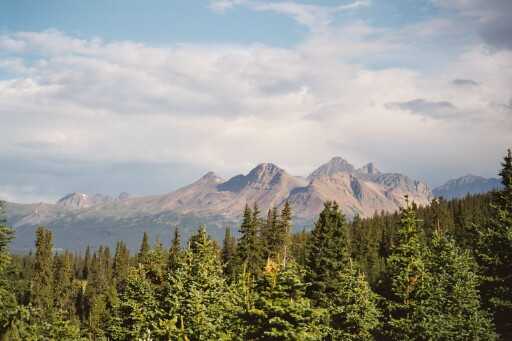
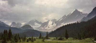
Mt Robson & The Tonquin Valley
August 3, 2003 - Jonas Creek CG
This morning (Sunday) was a bit frustrating as we did last minute errands - looking for fuel for our stove, a cooler (that took four stops) and a few fresh groceries. Calgary is about an hour and a half east of the mountains, so it was noon before we reached the tourist town of Canmore, gateway to the mountains. We finally found our cheap cooler there, but the town was so busy we really didn't want to linger long. Besides, I was really anxious to get into the mountains, so we didn't even stay for lunch.
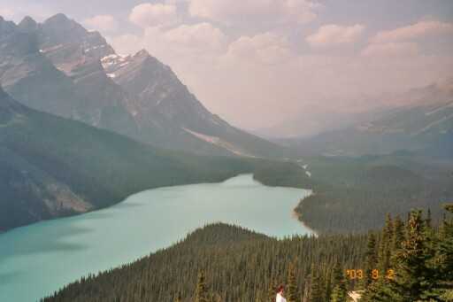
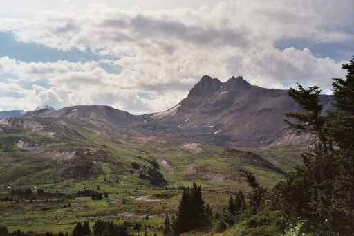
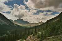
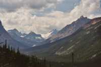
Soon we entered Banff National Park and discovered that the haze that obscured the mountains all morning was more than just clouds, it was smoke from fires nearby. The rangers at the gate didn't mention them, but the smell and burning eyes were unmistakable. We headed north up the Bow Valley Parkway and then the Icefield Parkway. We could see peaks right over head, and rivers just below, but nothing at any distance or with any clarity. It got better as we headed north, but still it was really disappointing. We can see that there are dramatic peaks and glaciers, but we can't take any pictures as they would just show grey lumps against grey skies. Still, we couldn't resist entirely, so we shot a few mountains, beautiful blue Peyto Lake a thousand feet below the overlook, a couple of waterfalls, the Saskatchewan River, etc. The land didn't disappoint, just the weather. (But for wanna be photographers, it was not happiness.)
Our general plan is to drive as far north as Mt. Robson Provincial Park, about 250 miles north of Banff, and then work our way back south, hiking and backpacking along the way in Jasper, Yoho, Kootenay and Banff National Parks. We didn't actually make it all the way today, thanks to our late start and many stops. Jim was driving slowly so we could enjoy the views and look for wildlife (none so far except ravens and magpies.)
By the time we were ready to stop for the day, the campgrounds started showing "full" signs. At the third, Jonas Creek, there was no such sign, but all 20 or so sites were occupied. Finally we spotted a sign that said, "Walk-in sites" so we climbed a steep little hill and discovered a dozen more tentsites scattered in the trees. It is much nicer than the car camping area. We can hear cars on the highway, but they are far away and we can't even see the nearest tent, though I hear a child laughing nearby. It took several trips to bring our gear up here since we were not at all organized, but this is much better than the regular campground. We have a picnic table, a flat spot for the tent, and even an outhouse 100' away. The sun is shining, the skeeters are biting, and I'm happy.

I was really anxious today, wanting to get moving, to get to Mt. Robson so we could start hiking as soon as possible. Two weeks is just too short. We didn't plan this trip in any detail. I read all the guidebooks, and made lists of hikes I'd like to do, but Jim wanted to be flexible and play it by ear and not feel pressured to keep a schedule. Oddly, I feel more pressure this way because I'm afraid we won't be able to do any of the hikes I really want to do because the reservations aren't available. Since we're hiking in National Parks, you have to have permits. Jim doesn't care. Since he hasn't been studying the books, one place is as good as the next. It is all beautiful. I have specific places I know I want to see, but between the fires, the haze and timing we may not be able to do any of them. Or, I may be totally off base and we'll be fine. Distances are the problem - it is 450 km from Calgary to Mt. Robson. That's a long way. The roads are scenic and fairly slow. Campgrounds are widely scattered and some are small - 20-30 sites. Hotels are utterly out of our budget - $200 and up. So we need to stop early in the day rather than late. I think I'll be fine once we actually do some hikes. It will take me a couple of days to slow down from my city pace and mellow out. A quiet night camping will help, I'm sure. All the people - mobs everywhere - are getting to me. The towns, Canmore, Banff and Lake Louise, looked like zoos as we passed by. Cars and buses and bikes are everywhere. Every overlook and trailhead was full of vehicles, and the park entry stations had long lines. This isn't like our Beartooth trip last year, more like a summer day in Yellowstone or Yosemite. My head knew it would be like this, but I thought it wouldn't matter since the beauty is so awesome, but it does get to me. We walked to the Peyto Lake Overlook 1/4 mile or so and couldn't see the lake for the people. It was a pretty spruce forest though, with a few wildflowers scattered about: western anemone, paintbrush, fireweed, asters, etc.
The mountains and glaciers are beautiful, even hidden in the haze, but the lack of clarity really is a disappointment. Still, I do like rocks and swift milky glacial streams and wide braided rivers and little red squirrels and the scent of firs. After supper we followed a cascading creek from the campground to the main river. We didn't see any animals, but we saw moose and bear scat. The river was really roaring; I'm glad we don't have any hikes with major river crossings planned. I suppose the warm dry weather is really making the snowfields melt.
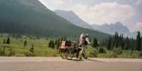
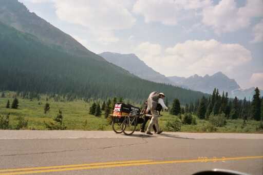
One interesting event: as we drove up the highway, we spotted a man walking up the road, pulling a cart. I realized that it was Karl Bushby, a Brit who is attempting to walk around the world. He started at the toe of South America and, with great difficulty, including all sorts of visa problems and a stolen cart, has made his way up into Canada. I wouldn't want to do what he is doing - road walks along busy highways - but I admire his perseverance. We chatted a few minutes, then drove on.
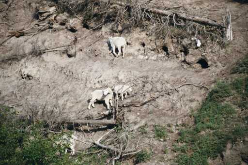
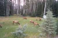
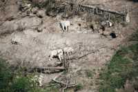
Jim: The drive to Jasper along the Icefields Parkway was a good one - lots of wildlife, bunches of mountains, good road, easy driving, great scenery and more glaciers than I've ever seen in one place before. As we drove north, the smoke even abated somewhat and we got lots of pictures. We'll see how they look when we get them developed. We even managed to stop long enough to meet Karl Bushby, the Brit who's walking around the world calling his trek The Goliath Expedition. He left Calgary on July 24 and we passed him on the Icefields Parkway north of Lake Louise. Stopped and talked to him for a while. Took pictures, of course. We also took pictures of the mountain goats (mama and baby) at a salt lick alongside the road. Then when we got on the outskirts of Jasper, there was a whole herd of female elk - again, grazing alongside the road.
August 4 - 12 miles to Marmot Campground by Berg Lake
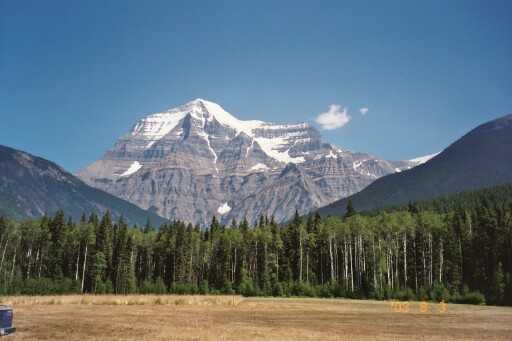
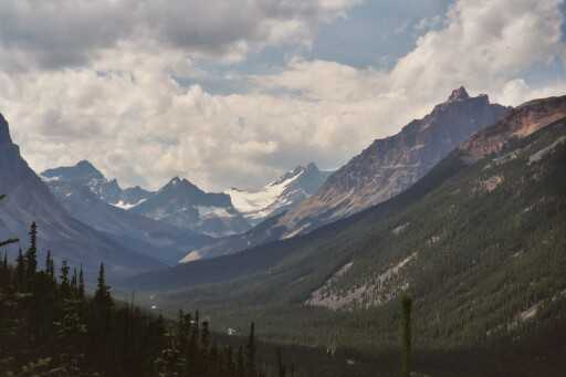
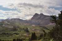
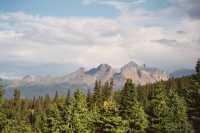
Today was a good day, much closer to what I had hoped to experience up here. It was in doubt for a while. This morning we spent some time trying to get organized, then headed toward Jasper. We stopped to look at one enormous waterfall, Sunwapta, and enjoyed the drive north. It was still hazy, but not as bad as yesterday. In Jasper, however, we discovered that there were several fires burning in and around the parks and a large area has been closed to visitors. We decided to continue west to Mt. Robson, which is on the west side of the Divide, in hopes of finding clear skies and open trails. Sure enough, the other side was much better, though the ranger told us that there were several fires burning in British Columbia, one of which had burned 50 km of power line so the park had no electricity. The only gas station in 50 miles had no working pumps, and the water system wasn't functioning, so they were planning to bring in a generator, but the Park was still open and giving out backcountry permits. Moreover, we weren't breathing smoke, the skies were blue, the ridges clear and I was much happier.
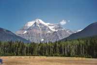
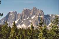
Mt. Robson rears in snowy splendor right behind the Visitors Center. It is really beautiful. Many people do a day hike 4-7 km to Kinney Lake, so they can enjoy the views of the mountain rising above the opalescent river. Beyond Kinney Lake the trail continues for miles, back up into Jasper NP, with campgrounds at frequent intervals. Still, I was surprised when the ranger said we could get a permit to camp by Berg Lake tonight. We had a choice, 7 km to Kinney Lake or 19 km to Berg Lake. Even though it was past noon, we opted for the 19 km trail (11.5 miles). I was so excited. We threw stuff in our packs, forgetting a few items, but nothing essential. We had eaten brunch in the town of Jasper, so we were full of energy, and up the trail we headed. The parking lot was full, so we figured there would be lots of people along the trail; we were right.
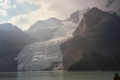
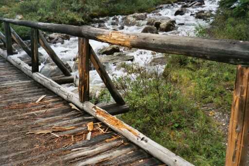
The first few miles were an easy flat road that paralleled the Robson River. It was a real rushing river, not wide, but swift. Kinney Lake was a couple of miles long - actually a naturally dammed river, and the upper reaches were just a wide rocky valley with multiple braided streams. We crossed it on a series of small bridges. We stopped to cool my feet off at the lake near the first campground. Above the second campground was the Valley of a Thousand Waterfalls; there weren't quite that many, but over a dozen could be seen cascading down from the glaciers above. Some were fine veils, some were long cataracts that dropped 1000 feet or more, some were fat full-force torrents. It was really beautiful as we climbed and climbed up the valley past more waterfalls. Our total climb was about 3000', though some parts were nearly flat and other sections climbed and then descended. Some sections were very steep, but it was really beautiful. Some of the trail went through cool forest, almost a rain forest, that was green with thick moss and ferns, huge red cedars and hemlock trees.
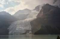
Jim and I discovered that we are really out of shape as we climbed and climbed. Our late start made me feel a little pushed - 12 miles of hiking starting at 1:00 is not unusual for us, but not usually with packs on. We couldn't really hurry, we were simply too tired. We finally reached the upper valley and it was quite different from what we had seen in the valleys below. This is a wide rocky glacial valley with two glaciers opposite our campsite that extend almost all the way to a lake below. We hear loud cracks and avalanches as the ice calves off the glacier. At the foot is Berg Lake, which is a large one with a milky blue color. We're camped at the foot of the lake and will hike up past the head tomorrow. Although this campground has seven tent sites (square platforms filled with wood chips) there is only one other group here tonight. We didn't arrive until 7:00 local (British Columbia) time - 8:00 Alberta time. Last night it didn't get dark until almost 10:00, so we knew we had enough time in that sense, it was energy that was lacking. But it is all very beautiful, and though I'm tired, I'm happy.
We didn't see any wildlife on the trail aside from the usual squirrels, chipmunks and picas, but earlier as we drove north we were much luckier: at an area known for mountain goat sightings (there is salt in the rocks) we saw a very mangy female and her young kid. We watched them for a while, then ended up out in the middle of the road stopping traffic so they could cross safely. Then, a couple of hours later, Jim spotted two elk browsing by the side of the road. We watched them for a while until some cars pulled up right beside them and the elk got nervous and moved off a few feet.
Other highlights: a great swinging bridge, to be crossed one at a time, and even then it was in full sway. We talked to a couple of dayhikers by Kinney Lake who decided to make the switch to backpacking after meeting several backpackers on their dayhike. There are several outdoor stores in Jasper and they plan to go pick up a tent and stove and come back tomorrow. We'll see. Our campsite is up above the lake, with views of the glaciers and glimpses of Berg Lake below. Beautiful. There is a bearpole and an outhouse, and an area to wash dishes. The ranger said that bears are very scarce, but we still need to hang our food. A black bear was seen up in the hills above a few weeks ago with her cub, but no grizzlies. How disappointing!
It was very warm hiking today, but tonight is quite cool. The stream water was icy. We had to cross the braided stream on several log bridges. Down below, there were nice wide horse bridges. The higher we got, the simpler the bridge. Although some horses are allowed, they are restricted in the park and in several stretches they have built alternate bridgeless routes. (One family has grandfathered rights to take their horses through the park, so once a year they have a family camping trip up here. Also, rangers from Jasper NP on the North Boundary Trail circuit come through Mt. Robson every couple of weeks on horseback. The commercial packers would love to be able to come here, but are not allowed. Yea!)
Jim: At Jasper there were even more fires, although the Syncline fire on the eastern slope was nearly under control by the time we got there. Regardless - they had closed many of the trails due to fire danger - and we couldn't get a backcountry permit. Yeah, you need permits to backpack in the Canadian Park system. You also get to pay for those permits - as well as for a daily (or yearly) Park entry permit.
So, since we couldn't backpack in Jasper NP, we changed direction and went west - to Mt Robson Provincial Park. Wonderful decision. On the way to Robson, we got our first bull elk picture - he was a beauty - he was also feeding right beside the road. When you pull into the parking lot at the Mt Robson Park office, you're looking straight up at a beautiful 12,900+ ft snow and glacier-capped mountain. Better yet - they told us we could have a backcountry permit. Of course, our designated campsite at Berg Lake was a 20 klick, 800 meter elevation gain walk - and we were starting at 2 pm. Cool ---- well, OK - it was a bitchkitty. But doable. And we did.
August 5, Marmot Campsite at Berg Lake - 10 miles to Mumm Basin
Another beautiful day. It sprinkled on us during the night, and clouds have come and gone all day, but mostly we've had warm sunshine and cool winds.
This morning we left our tent and gear behind, taking only one pack with food, water, rain jackets and such, and headed up the valley in the woods just above Berg Lake. The mountain above was buried in cloud. We could see small icebergs on the lake, a few of the many that broke off quite noisily during the night. We passed a couple of campgrounds, including one big one with a huge shelter and running water, before heading on a short side jaunt toward Snowbird Pass, a very popular dayhiking destination. We had heard that it was a steep climb on loose scree to get there, so I decided I didn't care how good the view was, I'd rather go elsewhere, if possible.

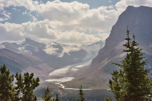
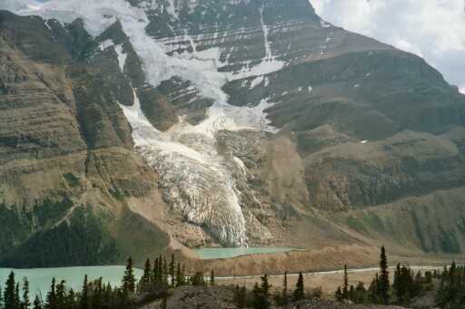
The trail goes past the foot of Robson Glacier, and we decided to hike as far as the lake at its base, just to see what the back side of Mt. Robson looks like. Rocky! There was a sign at one spot indicating how far the glacier has receded in the past 90 years - 50 feet a year, at least. The glaciers have been melting for hundreds of years, but it was 90 years ago that the Alpine club of Canada marked its farthest reach. Now there is a mile of boulders and gravel between that spot and the ice. The moraine beneath Mist Glacier was interesting - a 40 or 50 feet tall wall of gravel, enclosing a little lake and surrounded by the rest of Berg Lake. From lakeside, all you see is the wall, but from above, the blue lake behind it is clearly visible.

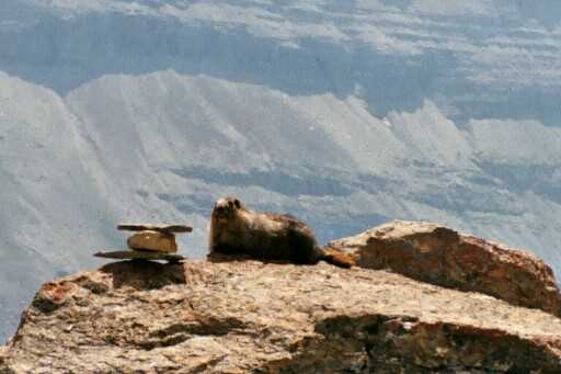
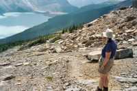
We went a mile up the Snowbird Pass Trail, then turned around at the lake at the foot of the glacier. Then we headed up the Mumm Basin Trail, which climbs extremely steeply up the side of the valley, 1500' in about a mile, crosses briefly over into Alberta and Jasper National Park, then heads back along the ridge for a few miles before descending again to our campground. The views were beautiful. The scenery was the same as what we saw from lakeside, but more expansive - bird's eye views. We had a very hard time with the steep climb and rocky descent, but it really was worth it. There were lots of wildflowers too: columbine, yellow and orange paintbrush, heather, asters, etc. We're past peak for the flowers, but there are still a lot of varieties in bloom. Wildlife consisted of several marmots, chipmunks and a couple of deer wandering around the campsite.
The only negative note was the really obnoxious constant drone of helicopters. Evidently they do tours around the mountain and drop off hikers who want to walk downhill all the way. There were way too many helicopters. I think they are restricted to a certain number of days a week, but any days are too much.
We're both tired - completely worn out - even though we only walked about ten miles today. Jim won't eat when he gets really tired, which doesn't help his energy any. My feet are sore from descending along the steep rocky moraine. We only saw one group along our route, coming the other way. We checked out another glacier, Hargreaves, and its lake. To do that required a steep side climb up another moraine. Not really worth the effort, but it was there, en route, so we had to try.
As hard as it was, today was a really good day. The best part was our long lunch and nap in the sun, looking out over the three valleys and snow covered peaks. Back at camp, happiness was getting cleaned up with water that had been lying out in the sun all day and then sitting by the tent, reading and writing while looking out at the two glaciers across the lake.
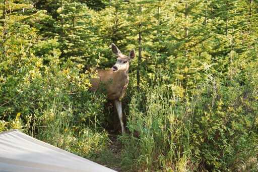
Jim: The trail to Berg Lake passed a whole bunch of absolutely beautiful waterfalls, including one area called the Valley of a Thousand Falls. Our campsite for two nights was directly across Berg Lake from the Berg and Mist glaciers. And we spent two nights listening to those glaciers calve - sounded like freight trains all night long. And then there were the wolves. We also met Charlotte and Charlene - the two local campground mule deer who kept wandering through our campsite.

The next day, we got our second lesson in "Canadian trails" - a short side trip to see the Robson glacier followed by a 1600 ft climb in something under a mile from Robson Pass into the Mumm Basin - and then a long, loooong descent back to our campsite across flower-filled meadows, then scree and talus fields. Between the flowers and the views, it was worth every bit of sweat and strain it took to get up there.
Wednesday, August 6 - 12 miles - Whistlers Campground near Jasper

It was a quiet night aside from the frequent crash of ice from the glaciers. We woke to a gray, hazy, cloudy day. Our descent was fairly rapid, aside from a long chat with a ranger/warden. On her recommendation, we followed the horse path across the gravel flats for a mile or so - quick easy walking with less roller coaster up and down. The last few miles it rained on us, first light sprinkles, then a soaking thunderstorm.
We drove back to the town of Jasper, got a site at a huge campground, stopped to look at a herd of elk, mostly females and their young, some still with spots, then went into town to find out about fires and trail conditions. We got a permit for our next backpack trip - another three days - asked about trail closings and decided not to worry about the following stretch quite yet. What's the point? More rain may put out the fires, or lightning may start new ones. Tomorrow we'll see Maccarib Pass, and that's as far as we need to know right now. After a big hamburger and a quick trip to the grocery, we returned to the campground where we sorted out gear and food, hung up our wet clothes, and went to a presentation on grizzly research. It was very basic and aimed at kids, but fun.
Jim: Today was "going out" day - we got to descend that lovely 20 klicks/ 800 meters -- in the rain, of course. Yeah - while we were in the Mumm Basin looking at all those mountains and glaciers, I got to thinking about all those fires and how we might not be able to hike much more in Jasper if they kept on going, so I invoked the rain gods. And they answered with a soaking rain that helped to at least get some of the northern fires under control. Yeah, Mark - we actually tried to find the weather witch. But that didn't really work all that well. Someone's got her trapped on the East coast, I think.
Thursday, August 7 - 12 miles over Maccarib Pass - Maccarib Campground
It rained during the night and we woke to low clouds and no mountains, so we decided to go to town (three miles away) to have breakfast and dry out our soaked clothes from yesterday at a laundromat. We should have washed them as well, but that would have taken an extra hour and we wanted to get on the trail. Jim took down the tent and packed our gear while I sat and waited at the laundry. It was a busy place. Jim stopped at a camera store to see if the owner could clean out the camera. He fell yesterday while he was holding it and it landed under him in the dirt, collecting quite a bit of dust and grit. It seems to work, but we'll see whether the pictures turn out. All in all, it wasn't a great morning, despite the nice breakfast buffet at Papa Georges.

We drove to the trail, packed our packs and set off about noon. The clouds lifted, though they returned off and on all day, threatening but not delivering rain. The first part of the hike followed a cascading stream through the woods. We climbed above the trees and had nice views of the valley. The head of the valley was a wide glacial cirque, green meadows filled with flowers. The climb over the pass was a good one, and so beautiful with the black and red mountains and flower-filled meadows. Then we descended through open willowy meadows with beautiful views of the mountains, following a stream. Our campground is one of the most beautiful I've ever seen - up on a low ridge with views back toward Maccarib Pass and forward to the Ramparts, dramatic steep dark cliffs with snowy patches and glaciers.
The Tonquin Valley is really beautiful. It is also crowded. The tentsites are about ten feet apart and all eight are in use. There is a group here, some not very experienced campers who are out for a week. I had to bite my tongue when I saw that they had been washing their dishes in the stream. We'll be here with them for two nights, and it would have made things very uncomfortable if I started lecturing them on camping responsibly. The other absurdity is that there are two tables in the cooking area, one of which is slanted and so high you have to stand to use it. The benches are so high my feet don't touch the ground. With the other table the bench is only about two inches below the edge of the table - no one is that skinny. Mosquitoes are ferocious, but DEET is keeping them at bay, more or less. The other campers are all wearing headnets, which always makes me laugh. We have carried them many times, and never used them. If the bugs are that bad, we get out the repellant. The nets are too hot and block vision and make eating too difficult. The DEET stinks, but it works.
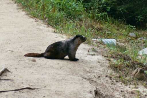
The only other wildlife we saw today were small animals: picas, marmots and ground squirrels. We had a fun one yesterday: a marmot ran into a culvert under the trail. We stopped on top of the culvert and looked down. Sure enough, in a minute he stuck his head out and looked carefully around. Finally he spotted us towering over him. He froze, then ducked back into the culvert. It was really funny. The night before last we heard a wolf howling, far away. I imagined I heard a response, but it was so faint it may not have been real. Today we watched a small hawk (falcon?) chase some birds through a meadow. We did see black bear tracks - two cubs - and many elk tracks, and some other bear sign as well.

All in all it was a good day. We got a bit bothered by all the muddy trail and the horrific damage done by horses since they really tear up wet trail, but we took our time and had a leisurely hike with lots of breaks to look around, take pictures and drink water. It really was magnificent. Having cool sunshine and occasional clouds was also a pleasure as I'm a little burned around the edges already and a lot of our climbing was over talus - open rock fields that reflect the sun.
Friday, August 8 - 12 miles Dayhike in the Tonquin Valley - Maccarib Camp

We kept our campsite and did a day hike across the valley, around Amethyst Lake, to the entrance of the Eremite Valley. Amethyst is a couple of miles long with steep glaciated cliffs rising above the water. Eremite Valley is a narrow side valley with several glaciers. We had hoped to climb up the valley, but that would have added four miles to the day and we decided that 12 miles was enough. Our lunch spot was really beautiful though and felt very remote. We saw one group on horseback and several groups of hikers, but it didn't feel as crowded as the Berg Lake Trail was. We followed some moose tracks, but the only wildlife we saw was a grouse family that blended into the grass extremely well. The meadows were wide and open, very nice walking. A lot of the trail was badly torn up by horses and erosion - not so nice walking. All in all, it was another good day. The sky was hazy again, but the mountains were still beautiful.
Sitting beside the stream in the sun, reading and looking up at the rocky ridges above is very peaceful. The camp is simply too buggy, so we're better off relaxing by the water for a while and eating a late supper. There are some big black cumulous clouds, so dinner might be delayed, but they've come and gone all day and so far we have stayed dry. This stream would be great to swim in. I notice that one of our neighbors washed her hair in the stream - -she left her shampoo package behind. Grrr! So much ignorance! This place is so beautiful, I hate to see it trashed. I tried saying something to them, nicely, "Here, you can use my water bag to get water to wash up away from the stream so you won't get soap in the water," but was brushed off, "It's okay, the soap is biodegradable." I told them it takes years for even the good camp soaps to break down, but they didn't want to hear it.
Jim: After leaving Robson, we went back to Jasper and managed to get a campsite, groceries, a couple meals and a permit starting the next day for two nights in the backcountry in the Tonquin Valley. Most of the other backcountry trails were closed except to dayhikers. Again, our campsite was a 20 klick 700 meter elevation gain walk, but this time we started about noon rather than at 2 pm so there wasn't the same sense of urgency about getting there. The Maccarib campsite is probably one of the most beautiful we've ever seen - it's on a ridge with killer views of the mountains in all directions, including a 12000 ft ridge called the Ramparts. The only problem is the mosquitoes - swarms of them. The other people at the campsite were bundled up like it was January in the Arctic - complete with mosquito nets -- when we wandered in wearing T-shirts. DEET is a wonderful invention.
Hmmm - the campsites - kinda like Glacier and Yellowstone - are limited, scheduled and assigned by the Park - and paid for by "you." Backpacking in Canada ain't cheap. Except that it is paid for in Canadian dollars. Not much privacy, as the sites are all right next to each other, but in grizzly country, that’s probably a good thing, in some ways.
Today we did a dayhike to Chrome Lake and the entrance to the Eremite Valley. The trail turned out to be much rougher than one might expect because most of it is used by commercial horse packers. And we followed a group of horses for awhile - even gas masks wouldn't have helped. But it was still a beautiful day and a good hike, paralleling the Ramparts and Amethyst Lake through the valley. The Eremite Valley is fairly remote and looks like a good place to come back and try again someday.
Saturday, August 9 - 12 miles on the Maccarib Pass Trail - Hinton
It rained in the night, but by morning the sun was shining and the air was crystal clear. We packed the wet tent after breakfast and took off about 9:00. It was an easy descent back to the car - it took about 4 1/2 hours to hike the 12 miles. We only took two snack breaks along the way. The clouds came and went but mostly it was a beautiful sunny day.

We took a side drive up to Mt. Edith Cavell to see if one of the guys we met hiking was there looking for a ride back to his car. You can make a half loop out of the Tonquin Valley area, but then you have a fairly long hitch back, which we decided we really didn't want to attempt. We didn't see him and the place was a zoo so we came back to town for a late lunch and to check trail conditions. We did a quick internet peek at Wilmore Provincial Park north of here since Kootenay and Yoho National Parks are still closed because of the fires and the Skyline Trail campsites are all fully booked. We need to decide whether we are going to do just dayhikes for the next week or try more primitive camping in Wilmore. I've enjoyed the beauty in the National Parks but the crowding has been really off-putting. We may go check it out just for drill. I have seen a website on the area, and seen how beautiful the mountains are (all mountains are beautiful), but it requires off trail hiking to get to the really good parts.
The rest of today will be spent doing laundry, taking showers, buying groceries for the next few days, and maybe we'll take the side drive to Maligne Lake if there's time. It's about 30 miles away, so it would take at least an hour, assuming no stops. It can be hard to get a handle on time. It all passes so quickly, except when waiting for laundry to dry, that time is always interminable. Even though it isn't fully dark until 10 or so, there just isn't enough time.
LATER: we decided against the trip to Maligne Valley as it would have required a couple of hours and by the time we left town it was already 7:00. We decided to head for Hinton, a small town about an hour west of the Park where we got a motel room, ate dinner and took very welcome hot showers. On the way we passed the still burning Syncline Fire - the biggest one in Jasper NP. It was a long term controlled burn that got out of control recently when the expected mid-summer rains didn't come. It burned a huge area. There are currently 29 wildfires still burning in Alberta (last week 41) and hundreds more in British Columbia. We also saw five mountain goats and a black bear hiding in the bushes, as well as a doe drinking by the side of the road. Odd, all that time in the backcountry and we saw nothing bigger than a marmot; we drive down the highway and there's all sorts of wildlife. I have hopes for Willmore, but we'll see.
Jim: About mosquitoes - I still say DEET is a wonderful invention. Not that we use that much of it, but we've managed to use up two 1-oz bottles of 100% DEET in the last 12 years. Plus the 1/4 inch that we used out of the bottle we took with us this trip. The mosquitos were a constant for the time we were in Tonquin - and I had a wonderful time killing the hordes that invaded the tent each night before we went to sleep.
Today was "going out" day again - funny thing is, we saw only one new group coming in. Got to wondering if we should have stayed longer.
Home | Links
The Thruhiking Papers |
Created: 09 Sep 2003
Revised: 30 Sept 2016Copyright © 2003-2017 Spirit Eagle