|
|
|
 |
 |
 |
 |
|
|
|
|
|
|
|
|
The John Muir Trail
July 1990
Yosemite to Tully Hole
Day 1 - Yosemite - 7 miles.
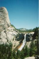
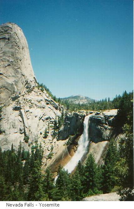
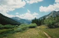
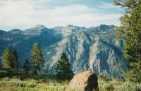
My travel plans worked out beautifully: I took a bus after work Friday to Merced, spent the night there, and took the local bus to the park on Saturday morning. There were only 3 Curry Co. employees with me to start, then the driver picked up a few tourists from hotels along the highway. He dropped me off at the visitors' center where I picked up my permit and caught another bus to the trailhead. After all my nightmares of racing around the valley looking for the right bus, it was nice to have everything work out so smoothly. Yosemite was a zoo. There really are a lot of people in the Valley. I don't remember the crowds from previous trips, but now the place is jammed. I started up the trail at 11:30 a.m. with about 20 people who were just going up to the waterfalls along the way. As I climbed steadily past Vernal Falls to Nevada Falls and beyond, I was constantly passed by day trippers out for a walk or a swim. It was a little discouraging, since the climb is a good one (3000') and my pack felt outrageously heavy. I took a long break swimming above Nevada Falls, but still was not in the least tempted to do the side trip to Half Dome. An extra 4 miles with that pack would have completely undone me. The falls were lovely: Vernal is just a small cataract, but Nevada is a long free dropping waterfall. Along the way were glimpses of Yosemite Falls across the valley, though the valley itself was quickly hidden, and I could see the smooth expanse of Half Dome and Clouds’ Rest above me. Along the stream above the falls were dozens of flowering yellow azaleas. Lovely. The forest, mostly red fir and pine, doesn't have many flowers right now, just a few lupine and paintbrush. I set up camp only 7 miles up in a little clearing off the trail. I had coolness and solitude and was camped well away from the stream. I could see a small rock dome just to the south with a green fringe halfway up and a totally round smooth pate, and another big one to the east. There are lots of glacial remains: domes and moraines.
Hanging up my food was rather more of an adventure than I expected. I can't throw. A branch tall enough to be effective (20 feet) is higher than I can get the rock, or if I go that high, I don't throw straight, or the rope got tangled. It took me 45 minutes that first day, and even then I only did it with the help of a huge boulder near the tree. I scared away all the wildlife with the noise I made. Meanwhile I was imagining a bear quietly cleaning out my pack while I was busy throwing rocks at trees. All I've seen are squirrels and chipmunks begging food, and several pack trains of mules raising dust along the rocky trail. I would like to see a bear during the day, but hope they'll stay away from my food. Current policy is to be aggressive and scare them off if possible, so I have a pile of pinecones just in case. Though the way I throw, I don't know how much good it will do.
Day 2 – Sunday - 12 miles, 20 total.
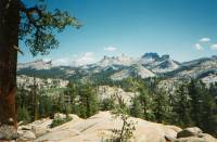
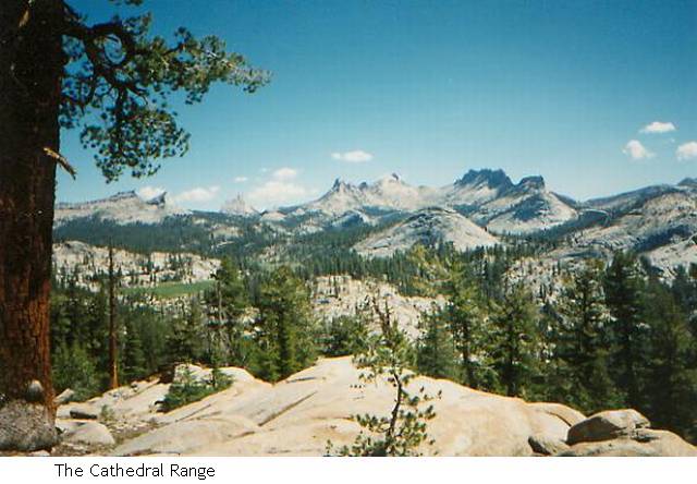
I hiked further today than yesterday, but still stopped fairly early as I can't camp too near Tuolumne Meadows. Four miles is the closest I can go legally, so I found a stream on the side of the mountain and a flat spot to set up my tent. I was really moving slow today, barely crawling. I hope it gets easier as I get more accustomed to the altitude. Of course a 6000' climb in the first 13 miles (including yesterday) is enough to tire anyone. It is so strange for me to be creeping up the mountains, usually I charge up, even with a pack. Of course, I have more weight than before on both me and the pack, plus two years and a lot of city soot in my lungs. I hope I am strong enough for the big passes coming up. Today was Cathedral Pass with lovely views to the Cathedral Range with Echo and Cathedral Peaks, Columbia Finger, Mt. Lyell and the snowy peaks to the southeast etc. I wandered past Long Meadow and the Sierra Camp there, and stopped for a wade in one of the Cathedral Lakes. There were dozens of ground squirrels in the meadow, and a fox and a hawk that followed the trail only one foot above the ground. He flew right over me, startling us both. There were also several marmots in the rocks above the meadow. Those meadows are such a vibrant green. Once they were lakes, now just a stream running through keeps them lush. I also saw a deer, the first in two days. There were, fortunately, fewer people. I talked with a woman who is staying nine days in the park, riding and hiking and doing the ranger led walks. There's a thrush whistling nearby and occasionally I hear voices on the trail, but otherwise all is quiet. I still have my city tension, but in a few days I'll completely relax, I hope.
Day 3 - Donahue Pass area - 14 miles, 34 total.
Today was a lovely day full of meadows and sunshine and water. Just beautiful. It was much easier as well, which definitely contributed to my good feelings. I got an early start, descending easily to Tuolumne Meadows. Crossing the enormous meadow, I saw a few trout fishermen out early. It's amazing how many backpackers I've seen with fishing poles. Then the trail crossed the highway near the general store, so I stopped in for juice and an apple. I had a long visit with a couple of P.C.T. hikers. They did the A.T. in 1987, averaging 19 miles per day! One woke up last night to find a bear stealing his pack right out from under his head. He gave chase and scared the bear away. They met someone who woke up to find his pack missing one morning. He searched high and low, finally he found it with the zippers neatly opened and the food all gone. I'll go on hanging mine, despite the difficulty.
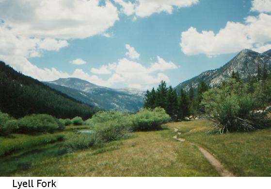
All day I followed the Lyell Fork, a beautiful blue stream, through green meadows, looking up at the Kuna Crest and later toward the glaciers on Lyell Peak. It was nine miles of easy flat walking, with only the last mile a climb to a table 1/3 of the way up to the pass. There are some barren lakes higher up with decent camping, but this is nice, and I tend to stick to a sure place over a possible spot later on that may or may not exist. I did enjoy myself though. The easy hiking made such a difference in my attitude. There was a beautiful waterfall coming down from Kuna Crest, about 1000' drop, not free falling all that way, but lovely. I liked following the river. At lunch I waded, then this afternoon I jumped in, clothes and all. They needed rinsing anyway. It was cold, but barely bearable. I didn't rinse my hair; it's not that warm outside. I have neighbors tonight, a group of six. There are some other people camped nearby too. Even if I don't talk to anyone, it's still nice to not be totally alone. I saw hundreds more ground squirrels (dog heaven). A couple were so busy wrestling they didn't notice me until I was right on top of them. They are so cute!
I went for an after dinner stroll and found a very young deer grazing on an island. He was curious about me and would take a few steps forward, then a great leap sideways to hide behind a bush with only his big ears sticking out, then he would peek at me, nibble a bush and shake his ears and tail, then leap out again. Finally he crossed the stream and vanished, but for 10 minutes we kept each other amused. I just stood still on the bridge over the stream laughing and watched his antics.
Now is the waiting time. The sun is behind the ridge, but it isn't dark yet and won't be for almost an hour. I'm winding down, running out of energy, but am not yet ready for bed. I don't want to read anymore, so I just look at the changing colors of the sky and listen to the water and the birds. The sun is barely touching a few distant peaks, hidden by the trees.
Day 4 - Tuesday - near Shadow Lake - 14 miles, 48 total.
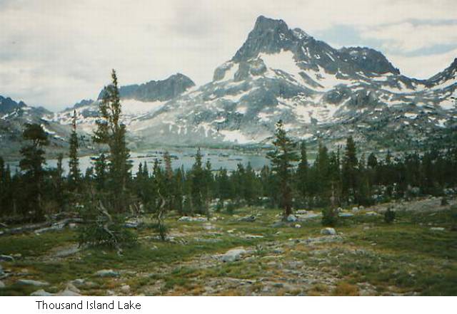
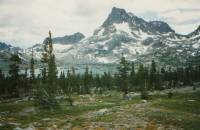
Today did not go at all as planned. I intended a long lazy afternoon at Thousand Island Lake swimming and resting. I had been there on a weekend trip a year before and couldn’t wait to go back. When I got there it was only 12:30, dark, cloudy and cold. The lake is still as outrageously beautiful as I remember it with Banner and Ritter Peaks looming over the blue waters, but cold and grey didn't appeal in the same way as my memories of it on a sunny August afternoon. We got a few drops of rain there at noon and still have threatening clouds overhead that could still open up. After talking to a couple of marines doing the JMT, I decided to go on a bit and try to reach Red's Meadow tomorrow afternoon. I'll use the extra day to stretch things when the passes are higher or the food bags heavier. The guidebooks strongly recommend not camping at overused Shadow Lake, so I found a spot on the Creek about half a mile away. I wanted open vistas and got mosquito infested pine woods again. Oh well.
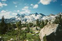
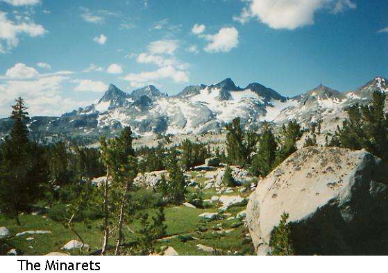
My bear-proof bear-bagging method isn't. I woke up last night to the sound of my food bag hitting the ground and the bear or bears climbing down the tree. Evidently the stick I was using broke. I yelled and clapped my hands and they went away, but I didn't sleep well after that as I expected them to come try again. Evidently they tried someone else though, since this morning I saw some lines dangling empty from a tree at a nearby campsite. Donahue pass wasn't nearly as bad as expected, and was really quite pretty with alpine plateaus and a little snow. It looked for a while as if I were going to climb Mt. Lyell; the trail kept heading straight toward it. At the top were fantastic views of the Minaret Range and a lovely descent following streams over islands and meadows and many criss-crossing streams. There were lots of boulder hops, but easy ones. For a short while I was on the eastern side of the Sierras, but a climb from Rush Creek to Island Pass put me back on the western slope for good. The descent from the pass was much as I remember Thousand Island Lake, so it made it easier to forego. Banner and Ritter also rise over Garnet Lake, a little further on, but there isn't much of a shore for camping, just rocks. There are lots of fish and fishermen there though. I saw a group of horsemen too that were completely off track. They asked if I had passed a trail to a certain lake, which turned out to be off in another direction completely. Oops. I spoke to two Englishmen doing the John Muir Trail northbound who said, "You'll see some tremendous scenery." But I don't think anything can be better than those snowy peaks over the lakes. (A lot of northbound hikers said that it was much prettier down south, but I thought that the north had a lot to recommend it with Donahue Pass and the domes of Yosemite and the snowy Minarets. Only the crowds and the mules were a real minus.)
The morning was very nice despite the climbs, but the afternoon was one problem after another. I was really set on having a short day, and after I decided to go on nothing seemed to go right at all. I am hiking better now that my food weight is less. Part of the problem may have been altitude. I wasn't sick, just slow. Surprisingly, after four days in the woods, I am not feeling at all deprived. Yes, the hot shower tomorrow sounds nice, but I'm not completely filthy thanks to a good water bag shower. The river was too icy to jump in, so I let the water warm up a bit in the bag before washing away from the stream. It was a quick one though since the mosquitoes were frenziedly feasting on my fair flesh. It was a fast and frantic frolic. I'm being silly, I must be tired. Anyhow, reaching Red's Meadow tomorrow means more weight on my back, not just a fun place to feast, so I have mixed feelings about arriving there early. There really are a lot of people out here, some for only a few days, some doing the John Muir Trail, and five, so far, doing the P.C.T. I saw a Boy Scout Troop on a long hike from Agnew Meadow to Yosemite (30 miles). Today's problem was finding a quiet corner to go to the bathroom without being interrupted. The two men I talked to today have been taking it easy. They started with 70 lb. packs, so stopped overnight at Tuolumne Meadows to mail some excess home. Then at Red's Meadow they'll take the bus to Mammoth, and at Lake Edison they'll take another break in Mono Hot Springs. Not a bad way to do it. They might as well be on the A.T. Still, I don't want civilization yet, and by the time I do, I'll be too far out to get to it. I think that is the one advantage of doing the trail in the other direction: by the time you start getting tired of rough living, there are ways of easing out. Still, I think it must be very hard to do that last 25 miles from Tuolumne Meadows to Yosemite Valley, knowing that you can get out early. One P.C.T. hiker told me that a lot of JMT hikers bail out at Bishop Pass, a weird thing to tell me, but then I don't look like a distance hiker-no long lean muscles or aesthetic taut cheeks. No, I'm round and soft, but tougher than I look. A little stubbornness/determination will take me a long way.
Day 5 – Wednesday - near Deer Creek - 16 miles, 65 total.
Another somewhat unexpected day, with a lot more mileage than planned. I thought I was lost for a while, which caused me to go further than I wanted. After climbing steadily for three miles after leaving Red's Meadow, I saw a sign saying "Mammoth Pass". There was no arrow, just the name. Since I knew that I was not supposed to be at the pass, but the old JMT/P.C.T. went there, I was absolutely certain that I had taken the wrong trail, even though there was a red mound nearby that could be the Red Cones on the map. I considered backtracking or bushwhacking, but decided to stay on the trail for a little while and take another trail that would lead me back in the "right" direction. I'm glad I did, or I would have really gotten lost. Finally after a couple of miles I found another sign in a meadow that told me I was exactly where I was supposed to be. What relief. But I had passed my proposed campsite, so had to go on till I found another one. It turned out to be a nice one near a small stream running through a tiny green flowery meadow between two piny knobs. There will be no people here, but likely no bears either since it is not one of the main camping areas.
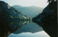
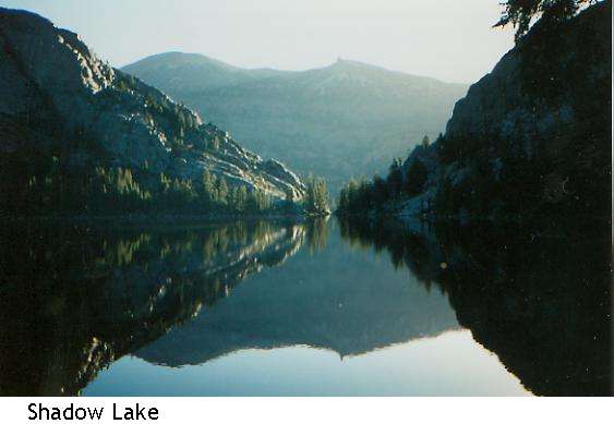
To start at the beginning: I got my usual early start and climbed past Shadow and Gladys Lakes enjoying lovely reflections of trees and hills in the water. A couple of hawks played leapfrog with me for almost a mile, screeching loudly as they flew past me from tree to tree. There was a good climb between the lakes, then a long easy descent to Devils Postpile, an interesting rock formation that I could glimpse through the trees. A little beyond is the campground and pack station at Red's Meadow. There were a lot of people there as it is near Mammoth and on the shuttle line from there. There is a store and diner, so I took a very hot shower in water from the natural hot springs, picked up the food package that I had mailed there, and had lunch. I talked to some guys doing the JMT from the south and a couple of policemen from Merced out for only a few days who were underexperienced and thus overstrained. Early in the afternoon I went on my almost lost adventure that wasn't.
So, how am I feeling about things? I'm tired, of course. I cut off a day more or less by accident and ended up pushing a bit hard. If the weather were less threatening, I'd be tempted to take a rest day, but the cloudiness doesn't encourage swimming and sunning. My early morning starts end up causing me to go farther than I planned, simply because it seems silly to stop at 1:00 with seven hours of daylight left. That has to stop. I need to take longer breaks and enjoy my free afternoons when they happen - use the time to explore more instead of arriving so tired I can't move. Mammoth didn't tempt me, despite the shuttle bus. I haven't gotten to be very hungry yet, so I have food left over in my pack, weighing me down. I ate a hamburger and ice cream for lunch, less because I craved meat and ice cream, than because I know that it will be weeks before I can have more. At Whitney Portal it will likely be another story. The two men I talked to at lunch looked like thru-hikers: lean, hungry and filthy. They said they'd heard of the milk-shakes at Reds Meadows three days ago and had been wanting one ever since. Sounds familiar. On the Appalachian Trail we planned menus days or weeks in advance: blackberry milkshakes in Shenandoah, AYCE waffles in PA etc. I've been stupid about my body: eating more than I want just to lighten the load, ignoring hot spots that are now blisters, not resting enough. I still have trouble breathing, which may be altitude, allergies or bad conditioning. Maybe I'm still clearing out the car exhaust from living in San Francisco. That's what it feels like. Still, I'm moving along all right. A little slow, even for me, but not bad. I'm getting back my outdoor ease - a sort of mental coasting, observation without analysis, a total living in the Now. This morning was ages ago, tomorrow is eons away. Only this climb, this lake, or this meal have importance. I know what lies ahead, but it doesn't matter, only this moment really exists. I do feel a bit lonely at times - not unhappy, just wishing I had someone to share the evenings with. But then, that's how I feel in the city too. Leaving the buildings at Red's Meadow I thought, "Now I'm beginning the real journey, this last was just warm up." Knowing that "civilization" was so close made a difference. Two days to the store at Tuolumne Meadow, two more to Red's Meadow, piece of cake. So even though I have been in very wild country--Donahue Pass etc.-- the closeness of resorts and the many many people out here made it feel tame. To be honest, the JMT is a tame trail in that there are so many people on it there never is a real wilderness experience. I camp in out of the way spots to give myself the illusion of wilderness, but it is a well-traveled route. I do worry about bears, but they are a problem only because there are so many people. I would like to meet some congenial people going my way. They must be out here, there are so many going in the other direction and they say they have met a lot of JMT hikers walking south, but I may have outpaced the ones who left on the weekend. Many will stop at Mammoth too. The only ones who have passed me heading south were the two Marines, and they were heading for town. They could catch up again as they are fast hikers, but I doubt it. They weren't all that friendly anyhow. Unlike the A.T., pairs stay paired, and groups are more closed. There isn't the same sense of unity and camaraderie I knew. Perhaps because this is just a vacation, not a major life-altering choice like an Appalachian Trail thruhike. Also there are no registers to start communication. Here you just say Hi in passing, and goodbye forever. It's different.
Day 6 - Thursday - Tully Hole - 12 miles, 77 total.
It's a gloomy gray day, rumbling and grumbling overhead, but so far only light sprinkles have fallen. My tent is up, but I won't go in there unless it starts pouring. It's too small to spend a comfortable afternoon inside. I thought of setting up my groundcloth as a sort of tarp canopy, but the trees are too far apart.
Later: Now I finally got the groundcloth out and have it just draped over my head. I can write without getting wet. Of course, I can't see and can barely breathe, but let's not get picky. I'm dry.
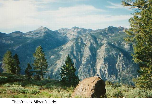
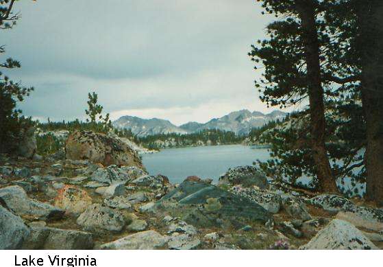
Anyhow, the clouds made cooler what otherwise would have been an extremely hot dry climb. It wasn't at all steep, just a steady six-mile rise on a dry dusty volcanic mountain. The rock was pink and grey pumice with some pine trees, but no undergrowth. No grass or flowers until we reached the streams. In many ways, the land reminded me of Tucson: hot and dry and dusty, but with pine and manzanita and occasional Indian paintbrush or lupine for color, then the lovely oases of the streambeds. I followed a more or less straight line today, about 1000' above Cascade Valley/Fish Creek, a very steep canyon. On the far side are the snowy mountains of the Silver Divide. On my side are a series of lakes--Duck, Purple and Virginia-- and red and white mountains. Duck Lake was off trail, but Virginia and Purple Lakes were quite different from each other. Purple is surrounded by trees and is a fairly typical large fishing lake. I saw someone in a rubber dingy far out in the water. Virginia was a more typical alpine lake with few trees, not one single lake, but a series of interconnected lakelets, surrounded by tundra and rocks. It was quite pretty actually, like Thousand Island Lake or the upper Rush Creek area. On a sunny day, it might have been a good place to swim, though I'm not sure if any body of water at 10,000', however shallow, is warm enough.
A little sparrow with a white striped head is investigating me. I've seen lots of signs of life here: field mice, chipmunks, birds, etc. Tully Hole, where I'm camped, is a meadow at the end of a valley with a stream snaking through it leading to Cascade Creek. Above the meadow itself are a few trees on a flat spot with a fire circle and log benches. By the signs, a lot of mule pack trains camp here. I heard something negative about Tully Hole, but I can't remember what. Whether bears, mosquitoes or people are the problem, I don't know. It is a pretty place. I like the spaciousness, being able to look across the meadow or down the canyon. I've had too many nights hidden in the trees.
I know the land is desperate for rain, but I do wish this low pressure system would move on. All my photos will be of grey lakes and grey mountains under grey skies. I want to swim, or at least enjoy lazing by a lake. Today's rain is more sound than fury. But at least it's a little wet, not just three drops of rain and move on. If it has to rain, let it rain, than we can get the blue skies back. This is the fourth day in a row like this, enough already. Tomorrow I climb Silver Pass, and I don't want to do it in the rain.
I saw a weird mountain near Lake Virginia-a white chunky tor, half crumbled away. No solid granite monolith, this was more a huge messy sprawling pile of white blocks. Above my campsite is Red Slate Mountain which I climbed last year from the other side. This valley is very different from what I remember though. Perhaps the leader pointed out the wrong valley when he said, "The Muir Trail runs right there." We're on the opposite side of the divide from where we camped last year. The JMT runs entirely on the western side, probably because there is more water. Black and White Mountain can be seen too from here.
Home | Links
The Thruhiking Papers |
Created: Fri, 09 Jan 2004
Revised: 30 Sept 2016Copyright © 1990-2017 Spirit Eagle