|
|
|
|||||
 |
 |
 |
 |
|
|
|
|
|||||
|
|
|
|
Absaroka-Beartooths - 2002
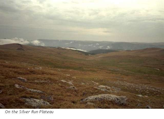
The Silver Run Plateau
Sunday, August 25 - Lake Fork of Rock Creek – 14-15 miles
Happiness is! A cool sunny day, 10,000 foot peaks, a cascading stream, the scent of pine and aspen – I love it!
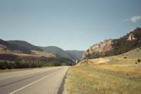
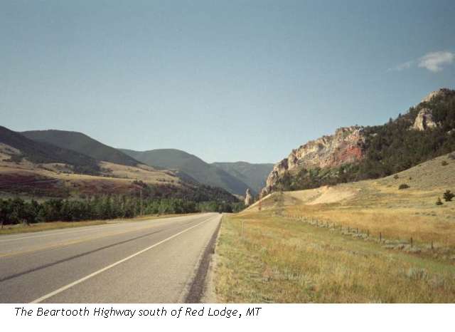
So far, all goes well. Despite different airline connections and a late flight, we were able to get together at the airport with our friend Mark easily, a car was available when we got there (turned out to be a minivan, but hey, why not?), the motel was quiet and the drive from Billings to Red Lodge was easy and pretty. It was typical Montana scenery: low hills covered with brown grass, sage, mesquite and aspen, cottonwoods along the river, with lots of cows, sheep, horses and ponies. Beautiful!
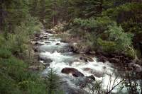
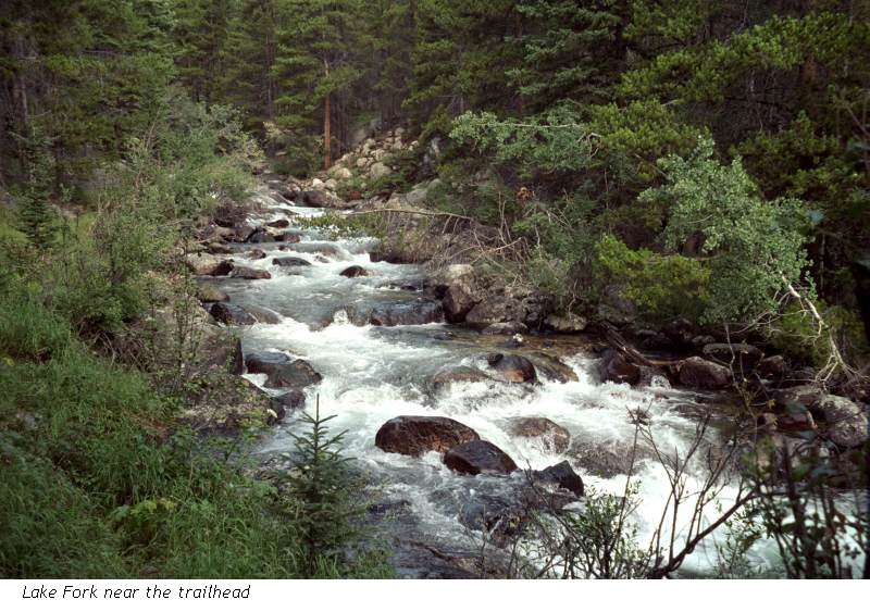
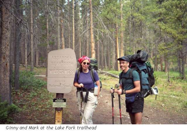
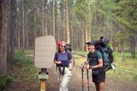
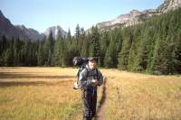
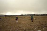
The trail we decided to take first starts out at a large trailhead near the town of Red Lodge (about 60 miles south of Billings) which contained several cars and horse-trailers when we got there at 10:00 a.m. We were warned. We saw 14 people in the first hour. Well, it was a nice sunny Sunday, so I shouldn’t have been surprised. After that, the crowds thinned out. The trail rises gently (1000’ in five miles) following a roaring, cascading stream. The canyon walls rise steeply a thousand feet above us. The jagged spires are beautiful. So far the only wildlife we’ve seen has been squirrels and chipmunks, though I look for animals up all the avalanche chutes. It is very dramatic, very beautiful.
I am feeling the altitude a bit. Just heavy breathing, right now, but it isn’t slowing me down much. The gentle grade helps. Also, I’m feeling so happy, I’m ready to fly.
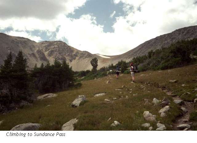
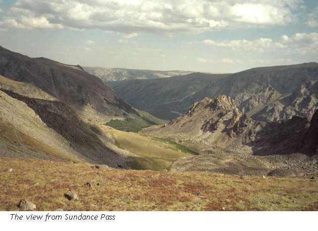
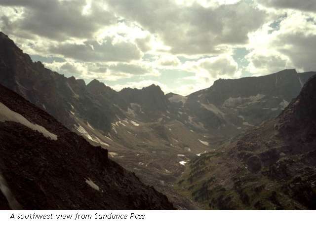
LATER: We had planned an easy 8.5 mile hike to September Morn Lake, but when we got there at 2:30, we decided it was too early to stop, so we agreed to keep going to the river on the other side of Sundance Pass. That was a mistake, because we got hit hard by the altitude. We tried to do too much too soon. It made a total climb of 3900’ from the trailhead, then a 2000’ descent on the other side.
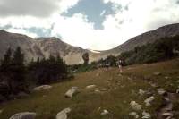
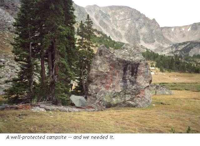
Since we live near sea level, and the pass was 11,000’, that was extreme. We were very slow climbing up to the pass, though the switchbacks eased up at the top. The views were incredible: icy glaciers, turquoise lakes, steep crags. We were in heaven. Then we quickly descended the other, steeper, side of the pass. They’ve built new trail, so it was much longer than we expected to descend to the West Fork of Rock Creek. We cooked dinner in a sunny meadow next to a bridge over the creek, then walked ¼ mile to a relatively flat spot in the trees. We met another hiker, part of a group, while we were cooking dinner in the middle of the trail. Our alcohol stoves throw out a pretty good flame, so finding a good rocky spot to use it is essential. In this case, that meant the trail was better than the meadow, and we really didn’t expect any other hikers that late in the day. The group was camped upstream a ways, so we never saw them, except from a distance as we were descending. Hanging the food cost time and almost lost us a rope, which got caught up in the tree.
Jim is very sick with a massive altitude headache and no appetite. I just have a medium sized headache. We’re tired and sore, but still happy. It is so beautiful here. We saw 20 people today, several picas and a marmot, plus squirrels, but no large animals. There were a few thunderheads, but no rain so far.
Jim: After flying into Billings, MT we rented a car (the irony is that they gave us a mini-van – the symbol of suburbia), and drove through Red Lodge, MT to the Lake Fork trailhead the next morning. Then life got interesting – because it was our first night at altitude, we were supposed to only walk 8 miles in and camp at September Morn Lake (9600’) that first night. Unfortunately we got to the lake at 2pm and, since we were working on an enthusiasm/adrenalin high, we decided to keep going.
At 4 pm we topped Sundance Pass at something over 11,000 ft and then had no choice but to descend the very steep backside of the pass via 4 miles of switchbacks (more than I was capable of counting at the time). Stopped for dinner at the West Fork bridge and then walked another half mile to find a campsite. 15 miles, a 4000’ climb and 2000’ descent is not a really smart way to start a hike at that altitude after coming from near-sea-level the day before – but it WAS beautiful up there.
Monday, August 26 – 13.5 miles – Silver Run Basin
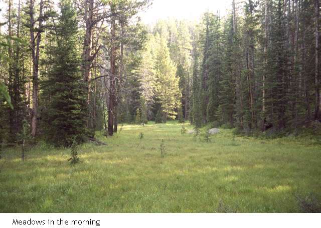
After our various aches and pains died down, we slept quite well in our quiet meadow. We woke to frost on the grass, but it wasn’t all that cold. Mark is an early riser, so he had already taken down our food from the tree where it was hung (and rescued the rope that was wrapped around the branch) so I just had to put on water for coffee and pour the cereal, then slide under my warm sleeping bag to eat it.
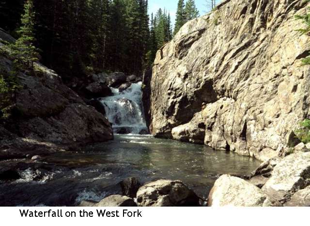
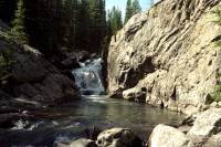
The trail was an easy long downhill trek, following the creek. There were several nice waterfalls, small meadows and lovely views of rocky cliffs. In many ways it is like the Sierras with the sheer granite walls all around and dense spruce below. We saw two bear tracks in the mud – a young bear – but saw only picas and squirrels that scolded us from the rocks. We saw six people today and one dog.
We stopped for lunch at the trailhead parking lot. We are hiking two separate trails, using dirt roads as connectors to make a loop. We’ll climb again once we reach the other trailhead, two miles up the road. Aside from slight headaches, we’re fine, though we worry about how we’ll do once we climb up above treeline again. Jim had wanted to do a side hike, a detour bushwhack from Mary Lake to Crow Lake, but we decided that it is too soon in our hike to attempt something that strenuous. It sounded interesting though. We’ll have a good climb in any case.
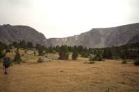
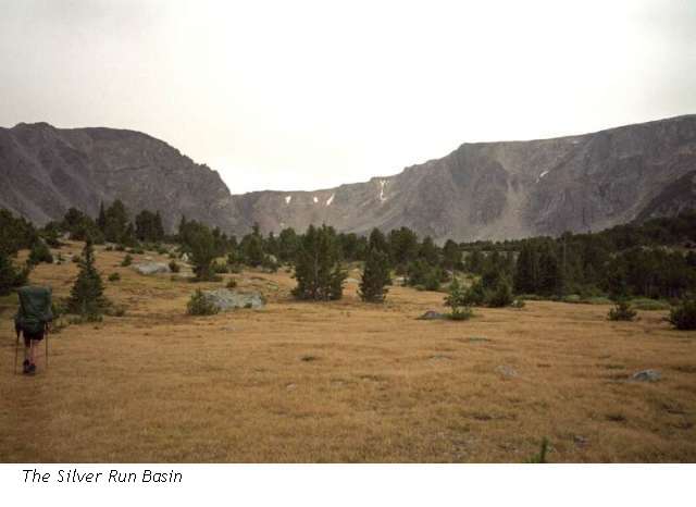
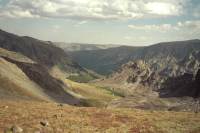
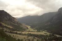
LATER: The climb was steep and slow through spruce and pine. After about three miles, just as I was trying to boulder-hop a stream, thunder sounded overhead and lightning flashed. I thought it was Mark taking a picture of us crossing the stream, it was so close. I fell off my rock in surprise. Rain and hail started soon afterwards. We ducked under a tree to wait it out rather than continue climbing, above treeline. Twenty minutes later the hail had stopped, so we kept going through a light mist. Half an hour later we arrived at the Silver Run Basin, a beautiful small glacial cirque below the Silver Run Plateau with 800’ rock walls on all sides, scattered trees and boulders, and a couple of small alpine tarns in the middle. The grass is mostly brown, but the willows around the water are still green. We tucked our tent behind a huge rock and cooked under the overhang of another. The quiet is absolute. A small waterfall way above us, a couple of birds and the scratch of pens on paper is all we hear. We saw some old bear sign on the way up and elk droppings, but the only wildlife was a flash of movement across a rock that Mark thinks was a weasel. The rain stopped soon after we arrived, but the dark clouds remain.
Jim: Today was a long run down the West Fork, followed by a long climb up Timberline Creek. The rain/hail started about an hour before we got into the Silver Run Lake basin (9600’) and then let up long enough for us to set up camp and eat dinner. But then it came back and we had a long night of extremely high winds, rain, hail and just general nastiness. Fortunately, we’d set up in the lee of a huge rock that Mahoosuc Notch would be proud to claim as one of its own and it sheltered us from some of the worst of the storm.
Tuesday, August 27 - Over the Silver Run Plateau – 14 miles to Red Lodge, MT
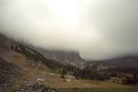
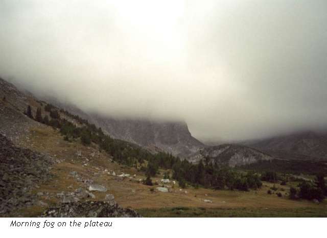
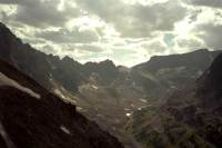
It rained off and on all night, accompanied by a ferocious wind. I was glad we were tucked behind a huge boulder, with trees protecting the other side. It was still grey when we woke up, with clouds completely covering the top of the plateau above us. We hesitated about going up to the plateau, given that there is a long stretch above treeline where the trail is supposed to be rather obscure, but being ‘intrepid’ (e.g. too dumb to quit) we climbed out of the Silver Peak Basin to the high country above. The clouds lifted as we climbed and for a while it was clear and beautiful.
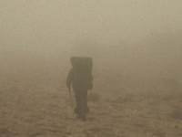
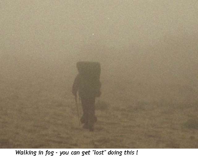
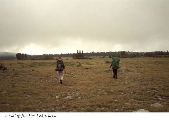
That didn’t last; as we hiked the clouds drifted in and out, hiding the rock cairns we were trying to follow. In high alpine meadows, there is little clear treadway, so often we had to spread out to search for cairns spread far across an open space. Since the trail winds round the streams and hills, the way really wasn’t obvious. There is only one junction up there and we missed it completely. It didn’t take long, fortunately, to realize that we were heading in the wrong direction (descending north instead of south) but it did take a long time to backtrack and find the trail we were looking for.
We weren’t sure how far back the junction was, so we headed cross country, looking for cairns or signs of human or horse passage. We did find a collapsed cairn, which didn’t seem to mean much of anything as there were no others near it, and a really nice hidden campsite about half a mile away from the trail, but it was interesting wandering across the open meadows looking for the cairns marking the trail. We walked right past it, across a stream, over some hills, and round and round in the fog. The map wasn’t much help as the land was rolling hills with lots of small streams, so the question was, which stream is this? And where are the cairns marking the trail? After much wandering we finally found the trail. Yippee! I looked at the map to see if we could just bushwhack off the plateau, but it is way too steep for that.
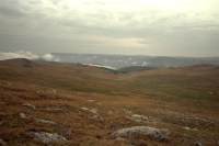
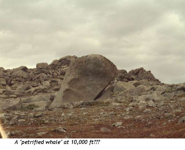
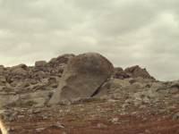
The country was really pretty, reminding me of Colorado at 10,000’. There was a lot of brown and red grass, a little lupine, some arctic gentians, low willow bushes along the water courses, scattered krummholz, and a few other flowers. It is autumn, as seen in the brown, red and yellow leaves. We could see fresh snow on some of the nearby peaks from last night’s storm. We weren’t very cold, fortunately. The land was mostly rolling hills, not quite as flat as it appears on the maps, but nice hiking. The descent was on steep switchbacks through dense forest –harder to go up than on the other side, I think, though it can be hard to tell. The land on that side of the ridge is mostly sage, with paintbrush and lupine to brighten things up. The trek back to the car along the jeep road seemed very long, though it was probably only about three miles or so.
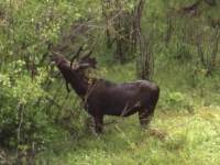
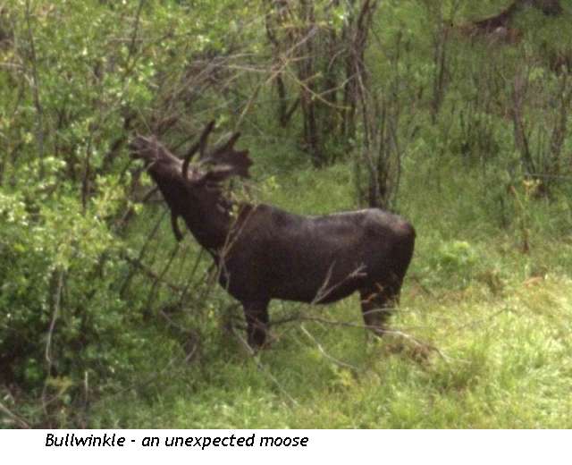
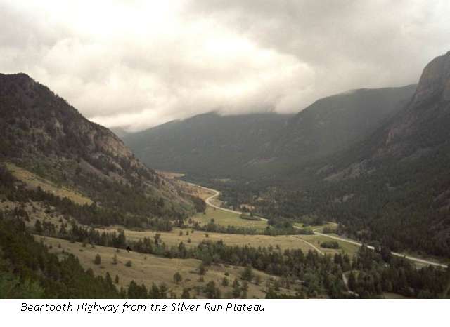
We all got upset when we were almost down to the trailhead and suddenly the trail veered north, avoiding some private property, and we knew we were supposed to be going south to our car. We finally cut across a sage meadow to the highway, where we walked a short distance before turning onto the road leading to our vehicle. It rained off and on as we were walking. Not hard, but just enough to merit a rain jacket We saw a big bull moose down near the trailhead, by a creek. The only people we saw were tourists with a vehicle, down by the trailhead. After being rained on all day, we were very happy to get into our car and head for nearby Red Lodge, where we got a motel room, did laundry and went out for pizza and salad and beer.
Jim: This morning there was no sunrise – only fog and rain on the Silver Run Plateau a thousand feet above us. There are warnings about not crossing the Silver Run Plateau in bad weather, but after some discussion we decided to try it. We started up the switchbacks and by the time we topped out on the plateau at about 10,600’ the clouds had lifted somewhat and we got intermittent sunshine for a while. Much of the plateau is typical high country meadow – wonderful country for elk, but while we walked on a carpet of elk scat we saw nary a sign of anything live. The elk had all dropped down to lower elevations because of the weather, so we were alone up there.
The trail (if it can be called that) consisted only of occasional cairns wandering across the plateau and required a good deal of searching on our part. The fog that rolled in over the plateau in mid-morning didn’t help the navigation problems much either. There’s only one trail junction on the plateau – and it’s unmarked, so if you see the cairn for one trail and miss seeing the cairn for the second trail, you get to head off in the wrong direction. You KNOW what we did, don’t you? Well, it wasn’t quite that bad – we only got a half mile down the wrong trail before realizing the problem – and then spent an hour looking for the right trail. In retrospect, it’s no surprise that we missed the junction – someone (time?) had destroyed the cairn that marked the trail we were looking for so there was no indication that the trail took off at that point. The rest of the day was a 4000’ descent through lodgepole pine forest and a couple mile roadwalk back to the trailhead. Then back to Red Lodge for pizza, a shower and reorganizing for the next adventure. We were supposed to have spent 4 days in/on the Silver Run Plateau, but between the weather and a great deal of enthusiasm/adrenalin, we finished the loop in three days.
Home | Links
The Thruhiking Papers |
Created: 09 Oct 2004
Revised: 30 Sept 2016Copyright © 2002-2017 Spirit Eagle