|
 |
 |
 |
|
|
|
|
|
The CDT in Glacier National Park - 1998
Introduction

Jim:Once again, Ginny and I had to decide what to do with two weeks vacation this year. Obviously we were going to hike - but where? After last years adventure in Colorado, we wanted to go to Glacier National Park and see another part of the CDT. But my work schedule looked like it was going to interfere, so we procrastinated about sending in the backcountry campsite permit request. Finally, the work situation resolved itself and about 5 weeks before we were to leave, we wrote a letter to Glacier NP telling them that we wanted to hike from Waterton Lakes in Canada to East Glacier Park at the southeast edge of the park on the CDT and requesting the permit. We didnt really expect to get what we wanted, since it was so late and parts of the route we wanted are very popular, but, as someone once taught me - "If you dont ask, you dont get". So we wrote the letter - and then started making alternate plans.
On Monday, July 6 - less than 3 weeks before we were to leave - the Ranger at the Glacier Backcountry office called and told us we could have the permits for what we wanted to do - if we could be flexible about the dates, distances, etc. And our answer was a resounding "YES". That meant we had to start hiking a couple days later than wed planned, do some longer (and shorter) mileage days than we would have liked, and take 2 layover days at Red Eagle Lake. Cool.
So why Glacier? First, because Ginnys wanted to go there since she was 8 years old. Second, its one of those high snow areas that catch a lot of thruhikers. Karen Berger and Dan Smith, for example, got caught by early snow and had to road walk the last couple hundred miles of their thruhike. Others have had to either finish or start their thruhikes via the alternate Belly River/Chief Mountain route, which is a lower altitude route, rather than the Highline (designated CDT) route. Knowing that we might get caught the same way next year, we wanted to do the Highline route this year so well have done it even if we cant do it next year during our thruhike. Third, doing the Highline/CDT route in July/August would also give us a chance to see Glacier at its best - during high summer.
Once again transportation was a problem. We could drive to Montana, but that would take 3 to 4 days and wed start the hike exhausted - and then have to drive back home - even more exhausted. Amtrak was a possibility, but neither of us liked the thought of spending 2+ days each way on a train. Since we got the permits so late, we were also too late to get the low-priced air fares, but I wasnt about to let that stop us. So the final arrangements were a combination - we flew into Kalispell, MT, stayed overnight and then caught the eastbound Amtrak the next morning to East Glacier Park. Thanks to Mark Howser, we picked up the permit, stayed at East Glacier Park overnight on Tuesday and then caught the shuttle to Waterton Lakes Park in Canada on Wednesday. Expensive - but it worked. In fact, 80% of our expenses for the two weeks were the transportation/lodging required to get to the trail and get home again.
When we picked up the permit, we also made arrangements to use the 2 layover days at Red Eagle Lake for some off-trail bushwhacking. We intended to use the old Red Eagle Pass Trail to get to Red Eagle Pass and then do the Norris Traverse across Norris and Triple Divide Mountains. This is a 4 mile section directly on the Continental Divide.
Resupply was no problem. With the consent of the Rangers, we sent a mail drop to the Ranger Station at Many Glacier, which was the destination on our fourth day of hiking anyway.
The altitude for this section of the CDT varies between 4000' and 8000', but is not such as to require extensive acclimatization. Most of the campgrounds are located at less than 5000' elevation, so we wouldnt be sleeping at 12000' like we were last year. That made it a lot warmer, and we didnt have to worry about altitude problems.
We used the Trails Illustrated map for Glacier/Waterton National Park along with Jim Wolfs "Guide to the Continental Divide Trail, Volume 1: Northern Montana" (published by the Continental Divide Trail Society). We supplemented the Trail Guide with sections from Erik Molvars "Hiking Glacier and Waterton Lakes National Parks" and the "A Climbers Guide to Glacier National Park" by J. Gordon Edward. We also carried a couple USGS 7.5' topo maps to cover the Red Eagle Pass and Triple Divide Mountain areas that we intended to bushwhack. The TI map has the alternate Belly River route to Chief Mountain marked as the "CDT" whereas the real designated route is the Highline route to Waterton Lake.
For the journals, weve included everything we wrote - including getting to the Trail and getting home again because its all part of the experience. What were not gonna tell you is how hard it is for us to come back - suffice to say that NO ONE talked to me at work this last week. No one wanted a repeat of last year when I made no secret of how close I was to quitting that first week back from the trail.
So - on to the main event ----
Tuesday - July 28, East Glacier, MT
Ginny: The first two days of our vacation have been very peaceful, but then, weve done little but wait. Its really very restful when you have no place you have to be, nothing you have to do but wait.
Monday we finished re-packing our gear (we had used everything on a weekend backpack on the AT and it needed to dry out before being re-packed), ran some last minute errands, waited for the airport shuttle (almost an hour late - was I in panic!), made it to the airport (a madhouse!) and waited for the plane. Despite the mob scene, we actually took off on time and arrived in Kalispell, MT early. Our airport shuttle was waiting to take us to Whitefish about 10 miles away for the night (the town only has 4 taxis) and everything moved smoothly. This is going too well, I thought. And sure enough there was one small glitch. The hotel had the wrong date for us and had us arriving a day earlier. They charged us for the night that we didnt use. The hotel owner was quite adamant that he didnt make mistakes, so the fault had to be mine. Right. Given the scarcity of rooms this time of year, and the fact that even doubled, it was less than some of the few rooms that were available, we couldnt fight it, but it was still upsetting. Since the airline didnt feed us dinner (Im not sure if that was good or bad?) we went next door to Dennys to soothe our woes with hot fudge/strawberry sundaes. Finally we crashed into late night oblivion.
Excitement woke me up early - at 5:30. We were supposed to be shuttled to the train station at 7:00, so we went next door for a quick breakfast, then rode the short distance to the Amtrak station in plenty of time for the 7:30 train. It was late, of course. (Evidently you can count on Amtrak to be late, at least in Montana. It explains the weird timing of the bus schedule, which leaves East Glacier 10 minutes before the train is due to arrive, thus making connections impossible. I guess they dont want to upset a lot of people by having them miss connections, so they make it impossible to make a connection regardless. This explains why we had 23 hours in East Glacier to wait for our bus north.) Anyhow, we read tourist brochures, admired the garden, wandered down to look at the "American Orient Express" a private luxury touring train that we saw featured on PBS a week ago and which was passing through Whitefish that morning. Finally the train arrived and we took off at 9:15.
The train is a good introduction to the beauty of Glacier as it follows rivers along the Parks southern edge. The immensity of the mountains is incredible - they are so vertical. They seem to rise straight up from the river in many places. No foothills. Big jagged blocks of stone. We arrived in East Glacier 1 ½ hours later. It was a slow ride, often only moving at about 30 mph, but pretty.
East Glacier is not quite what I expected. I think I was expecting another Lake City, but East Glacier is smaller, and even more rustic. It sits on the edge of the Blackfeet Reservation and aside from the immense lodge and train station (built in the 20's) is very unpretentious. A few small motels, restaurants (good food) and gas stations and two small groceries, plus some nice houses make up the town. Dogs wander the streets, kids sit outside the grocery and say hi to strangers, there are lots of lovely flowers, and it feels like a normal small town rather than the gateway to a big National Park. We checked in at the Brown House Pottery, a nice motel, and went over to the Two Medicine Grill run by an AT friend of Jims. Mark co-owns another motel, the Whistling Swan, which was booked the night we arrived, a diner and a car rental agency. He is one busy man! Despite that, he was extremely helpful to us, taking time to make us feel welcome. We said hello, watched him cook for a while, were inspired to order lunch (huckleberry milkshakes and delicious homemade chili for me, and a buffalo burger for Jim). Mark gave us the keys to his truck and sent us off to the ranger station in Two Medicine about 10 miles away so that we could pick up our backcountry permits.
A problem with relying on public transportation is that you have to pick up your permit by 10:00 am, but the bus doesnt even arrive at Waterton until 12:30, where there is a permit issuing station. If you dont pick up your permit on time, the reservation is supposedly wiped from the system. The only way to get the permit was to pick it up early, which is difficult with no transportation. For some reason, the ranger station in East Glacier doesnt issue permits. Getting use of the truck was a life saver. After the incredible luck in getting our permit on short notice, I would have been very upset to lose it like that. We spoke with the rangers at Two Medicine for a while, but wanted to wait for one who had done the backcountry off-trail route we were considering doing. He was out, so we ended up waiting for quite a while. This gave us time to wander to the lake, take pictures, admire the views, look at our map and play with the compass and check out the camp store. When we wandered back to the Ranger Station Dan Roy was there, but couldnt help us with the first part of our planned hike, as he hadnt done it. He was willing to help, but couldnt tell us what we wanted to know.
We got intrepid again. Our permit required two layover days right in the middle, at Red Eagle Lake. It is a nice spot, but thats a long time to sit in one place when you dont fish. Looking at the map, all the hiking in that area, besides our planned itinerary, is off trail. So we had picked up a climbers guide to Glacier which mentioned several non-technical climbs in the area. We got ambitious and decided to try a two day bushwhack from the lake and back, over what is known as the Norris Traverse. The ranger knew the traverse, but not about the unmaintained trail up Red Eagle Creek that was to be our means of access to Red Eagle Pass and the Divide. Supposedly Red Eagle Creek was once the most popular trail in the park. During WWII they stopped maintaining it. I don't know why. Maybe too many bears? Anyhow, the rangers were quite willing to let us attempt it, and to give us an undesignated campsite in the backcountry. After all the insistence on staying only in reserved designated campsites, I was surprised. The thought of this part of the trip scares and excites me.
I have been flying high off and on all day. It hasnt really seemed real - until we entered the park itself. All of a sudden the excitement and joy filled me to overflowing. I laughed and giggled and hugged Jim. Sitting by the lake looking at the mountains all around was also happiness. It was gray and hazy all day so colors were muted, but I saw flowers and sparkling waters and jumping fish and steep mountains everywhere we looked - happiness. Finally we drove around the campground, checking out the walk-in sites, gave a ride to two hikers heading there, and finally returned Marks car to him. We visited awhile, then went to Serranos, a Mexican restaurant, for dinner. It was surprisingly good. There is a grizzly bear conference in town. Jim recognized a few faces from books and articles hes read on the subject. I am struck by how friendly the people we have met here have been. Excellent service and lots of smiles. Different from DC.
Jim: From the time the Glacier Backcountry Ranger called us on July 6, our lives turned into a zoo. First, we didnt have the equipment to do the trip - we had sleeping bags for winter camping and some for summer in Eastern conditions, but we didnt have the 20 deg sleeping bags that we thought wed need for Glacier because those had fallen apart in Colorado last year. The pack Id used last year also needed to be replaced. Then there were transportation arrangements, motel reservations, Amtrak reservations, airport shuttles, cleaning and assembling our pack equipment, breaking in new boots, assembling a mail drop, mailing the stove, reading about the Park and the route, arranging for someone to watch the house and collect the mail ---- all while trying to keep our minds on work and hoping we hadnt hallucinated about that call from the Ranger. It was a little bit busy. ;-)
The trip to Glacier was long, but not really bad. With the exception of big city subways/Metro systems, this was my first train ride since I was about six years old - more room, more comfortable, more freedom and cheaper than airlines, although a lot slower. Tradeoffs. Turns out Amtrak only leases the line for their northern route and their schedule is subject to change on a daily basis. The main traffic on that line is grain - and its a money-maker so it gets priority. Amtrak gets whatever time isnt required for moving the grain and freight trains. Means the Amtrak trains are ALWAYS late.
The only negative note on the trip out was the owner of the Chalet Motel in Whitefish telling us that he had us scheduled to be there Sunday night rather than Monday night - and he was going to charge us for it. Claims he never makes those kind of mistakes. But we all know that Ginny and I were in PA hiking with Pittsburgh and Solar Bear, et al. on Sunday - it would have been a real trick for us to get to Whitefish, MT to stay there Sunday night, wouldnt it? Especially since our airline tickets were for Monday night - and that was part of the discussion when we made the motel reservations. I decided to let that one go for the moment - I wasnt about to let that kind of nonsense ruin my attitude about what we were doing.
On a positive note, Mark Howser was really a tremendous asset in putting this thing together. He arranged motel reservations in East Glacier for us, helped us with transportation, storage, and a lot of other small details. The trip would have been much more difficult without him. Again - thank you, Mark.
Being able to change the permit was a surprise - and I dont think wed have been allowed to if we hadnt talked the right talk when we were talking to the Ranger. His questions and objections were designed to find out if we were really capable of that kind of activity. I guess he thought we qualified. The Norris Traverse - its exciting - and scary. In part, because if anything bad happens, they wont come looking for us. They tell you up front that they wont look unless someone tells them youre missing. My kids and Ginnys mother and father knew we were in Glacier - but they knew nothing about our schedule or location. The only one who might have known we were missing was Mark - he knew where we were going and when we were to have been back at East Glacier. But that would have been a 4 or 5 day delay - and the bears wouldnt leave much in that time. For better or worse, we survived and thats the way I wanted it to be.
Wednesday - July 29, Waterton to Goat Haunt Shelter (9.5 miles)
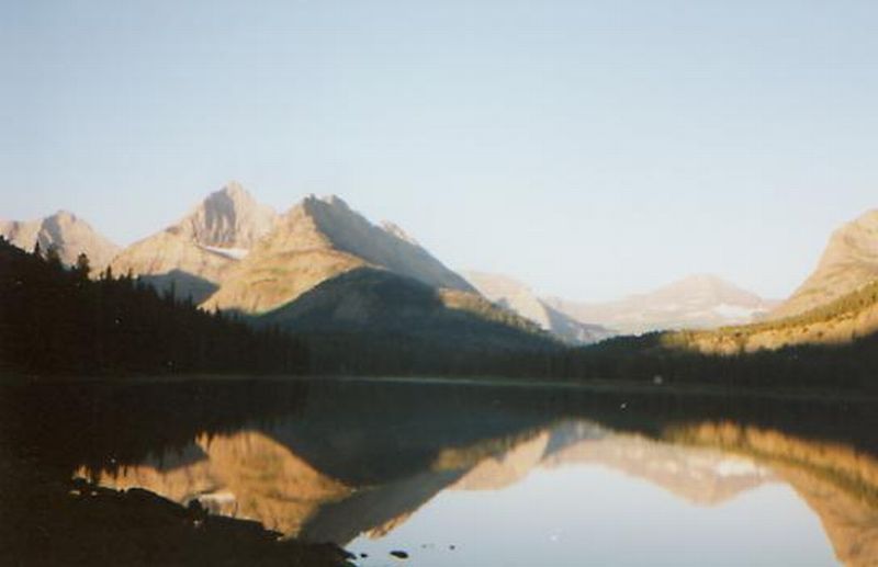
Ginny: I am sitting at a picnic table next to the boat dock at the south end of Waterton Lake. It is a big one. Hiking it from one end to the other took about 8 ½ miles. I look up at a dozen massive peaks, some with small snow fields, but most are bare. It was a madhouse here for a while, but everything seems to have calmed down for the moment.
We took the park shuttle, an old 1930's red bus, from East Glacier to Waterton, with stops along the way at Rising Sun on St. Marys Lake and at the Many Glacier Lodge. It was beautiful. We saw a moose in Swiftcurrent Lake at Many Glacier and a coyote near Rising Sun. My only complaint was that there were no stops for pictures.
We arrived at Waterton a little after 1:00, walked a mile or so into town from where the bus dropped us off -- the massive fantastic Prince of Wales Hotel, perched majestically on a hill overlooking the lake. Lunch at Zums with a delicious piece of wildberry pie (apples, raspberries, saskatoon berries, huckleberries and rhubarb!) got us ready for the search for the trailhead--not easy to find since the directions in the book are a bit vague. No mention of the Bertha Falls Trail which is the Canadian trailhead. We were warned via a sign at the trailhead to beware of black bears along that section as the berry season has started. Sure enough, there were thimbleberries, strawberries and a few huckleberries. The trail wanders up the lake with occasional views. No bears though. The trees are dense and covered with heavy moss, almost like Spanish moss. We saw some gulls, looked for mountain goats and saw a speck that might have been one.
We stopped at the international border for a long break. It is a long wide cut swath that runs thousands of miles along the US/Canadian border. There were posts that listed all the border treaties between the two countries. Making noise to scare off grizzlies means we wont see many animals, except at the high open areas, maybe. It was nice walking through pretty woods. There were a couple of far off waterfalls. I enjoyed the swinging bridge across Boundary Creek. It wouldnt be a fun crossing with the bridge pulled up for the winter though.
We arrived around 6:00 pm to find hiker shelters and a boat dock with a fireplace and real bathrooms. Lots of tourists take the boat tour across the lake instead of hiking there. We were supposed to check in with the ranger, but she was having dinner with friends so we went to the shelter to set up. We had the place to ourselves for a while. Then group after group came in and now the 8 shelters are full. They built two concrete buildings, each divided into four separate shelters, each shelter facing a different direction. It gives an illusion of privacy anyway. We face the setting sun and the lake.
They have a separate cooking area, well away from the sleeping area, so we were hidden away cooking dinner when the groups started to arrive. Then the last tour boat of the day arrived, and things really got chaotic. I stayed to guard the food and finish cleaning up while Jim went to make sure nobody got too nosy with our gear. The ranger said there was a black bear right down the shore when the boat came in. They had to destroy a mama black bear and cubs here last week who broke into the ranger dormitory and tore the place up. It made me a little nervous when I was sitting alone guarding the food. We had odds and ends to put in the bags before hanging them, like toothpaste and sunscreen, so I couldnt just hang the bags and leave.
We had a good day overall, but Im tired. The late start meant that we ended up feeling in a rush. Clouds threatened all day. It rained most of last night from about 4:00 pm until 8:00 am. Today was warm - hot when we were hiking - so rain could cool things off. Then arriving we hurried to cook and hang our food and all the cooking gear before dark. The tour boat left and the groups of kids are up the hill cooking dinner. It is peaceful at last. The sun is setting behind a mountain, but it will stay light here until about 9:30 or 10:00. I saw a beaver swim out right beside me when I wandered down to the shore. I think it was hiding under the dock as I heard a splash from there about 10 minutes before the beaver swam by. He was only about ten feet away when I saw him.
Jim:As usual, there was the last minute rush to get out of town. A couple things to mail, make sure weve got everything, dump some things out of the pack cause its too heavy, leave the duffel bags with Mark, get breakfast, catch the shuttle to Waterton Lakes and then "Oh my God, what did we forget?"
Too late ---- stops at St Mary and Many Glacier, then across the border to Waterton Lakes. We met another backpacker on the shuttle - he was taking the boat to Goat Haunt and then heading west across the park to come out at Kintla Lake. Said this was the 13th time hed been in the park since 1977.
Also met a group from San Francisco - they were on a hiking-drinking tour. Hike during the day and drink wine at night. They carried a couple of cases of wine across the border with them knowing that they werent gonna be able to get them back into the States when they came back the next day. The intent was for the seven of them to finish all 18 bottles of wine that night. Hope they were happy with the results. ;-)
The Prince of Wales is one of the main attractions at Waterton - its a magnificent old hotel that was built by the Great Northern Railroad (as were Many Glacier, Two Medicine, East Glacier, Granite Park and the other facilities) to attract tourists and provide business for the railroad. The shuttle let us off at the hotel in the midst of mass confusion and we were left to our own devices to find the trailhead. So we made a detour into Waterton Townsite to find lunch at Zums - where we again met our backpacking friend from the shuttle. Then out of town through the campground. Got some strange looks: we had backpacks, and everyone else in the campground was in trailers and huge family tents.
Finally found the trailhead and started south about 1445, got to the border at 1645 and to Goat Haunt Ranger Station about 1845. As we passed the border, the tour boat to Goat Haunt passed us and we once again got to wave at our backpacking friend from the shuttle. The border is marked by a straight-line strip thats cut right through the forest, supposedly all the way from the Great Lakes to the Pacific Ocean. The cost of keeping that strip open and cleared has to be enormous. The walk to Goat Haunt was fairly easy although a little overgrown in spots - especially on the US side.
The crowd at Goat Haunt was a surprise - when we first got there, we were the only ones in the shelter, but there was another food bag hung at the food storage area. Turned out it belonged to a group of guys whod been out for 2 or 3 days and had gone into Waterton on the morning boat for food, laundry, beer, etc. They came back on the evening boat and joined the zoo - by that time about 20 other people had gotten there.
The ranger was more than a little upset when we got there - theyd had to destroy a family of black bears the day before because they broke into the staff dormitory, trashed it and eaten a lot of the food that was stored there. Theres still a lot of bad feeling among the Park personnel about the family of grizzlies that had to be destroyed at Two Medicine, too. Those were the ones which had eaten part of the body of a young man who was out alone. There wasnt enough left of the body to determine whether the bears had killed him, but having eaten the body, they couldnt be left alive. The Park staff takes that kind of thing very badly. Seems nearly all the attacks/deaths that have happened in the Park have involved single hikers. Is there a lesson here?
My usual aversion to shelters also kicked in - after we couldnt sleep for a while - partly because of the noise from one of the groups and partly because the bugs were bothering me and partly because the concrete floor wasnt comfortable - so I crawled out and put up the tent and we slept out there until some idiot started chopping wood at 0600. Not the best start for our trip, but it could have been worse.
Thursday - July 30, Goat Haunt to Fifty Mountain Campsite (12 miles)
Ginny: Last nights groups were noisy: two groups of kids running and yelling and three guys, old college buddies, who talked late. At midnight Jim asked them to be quiet, but then at 6:00 someone woke us up by chopping wood for the fire. GRRR. We had a leisurely hike today, stopping often to look for wildlife. The flowers are shoulder high in places. So are the weeds, which completely overwhelm the trail sometimes. We made a side trip to Kootenai Lakes to look for moose, but none were showing.
Although the miles were few today, it wasnt an easy hike. Well, the first few miles were. We passed the ranger station and dormitory quite early (met a woman leaving the dormitory who said she was a grizzly researcher with USGS) and walked a few miles above the Waterton River through deep dark spruce forests. The trees are huge and covered with moss. It was an easy gentle uphill hike, to start. Then we started climbing - never steeply, but endlessly toward a ridge that kept receding as we approached. There were beautiful views of snowy Vulture Peak and other mountains in the Livingston Range. Now we are spread out at 50 Mountain campground. Glimpses of snow covered mountains to the right, flower filled meadows behind -- beautiful!
Jim:It was a long day for me and I was really glad to see the campground - and the stream that we managed to camp close to. The trail to Fifty Mountain was almost flat for the first five or six miles - and then it climbed for five or six miles. But the climb was worth it - if you climb up the trail a couple hundred yards from the campground, theres a 180 degree expanse of mountains thats just fantastic. This is part of the Highline Trail - and its one of the most beautiful sections of trail Ive ever seen.
The trail is really beautiful and generally well marked although it can be overgrown at lower elevations. After dinner we had our first thunderstorm - a short one, not much rain but a lot of wind. Sounded like a good time and a good excuse to turn in, so we did.
People - there were a couple guys who were Army buddies who come out to hike together for a week every year. One of them lives in Washington (state) and the other lives in Florida now. Then there was the group from Goat Haunt (the ones who had taken the boat into Waterton for the day). They had been buddies in high school - now one still lives in Minneapolis, one in South Carolina and the third in San Francisco. And there was a group which was conducting a guided tour of the backcountry for a German friend and were supposed to catch the afternoon tour boat out of Goat Haunt the next day (they left early the next morning). There were also a couple of guys whod been friends in college - both of them were from New Jersey, although one lives in Colorado now. Then there was our refugee - he was asleep when we got to the campground and apparently had nothing but a bedroll and saddlebags. Never did find his horse - but then I dont think he had one.
Friday - July 31, Fifty Mountain to Granite Park Campground (11.9 miles)
Ginny: There is a thunderstorm approaching. We had a gully washer yesterday right after dinner. I slept well. It was a beautiful hike today, high on the side of a mountain, all side hill with a 180° view of snowy mountains. We ran into a work crew filling in rockslides from all the rain. (The Going to the Sun Road was closed when we drove north because of a rock slide. There were a lot of unhappy tourists as that is the only road across the park. They had it open the next day though.) There were lots of flowers - yellow columbine, pink paintbrush, purple fleabane, many others. We had two easy snow crossings. Saw lots of marmots and what may have been a wolverine (or a VERY big marmot.) We saw a strange track in the mud just before there - all claws. The trail curved in and out of stream basins, Cattle Queen Creek and Ahern Creek, with views of Longfellow and Heavens Peak and glaciers and waterfalls far across the way. We stopped at Granite Park Chalet, rather like an AMC hut, where you pay big money for a bunk bed and no running water. We bought a soda and saw lots of dayhikers hiking the Highline Trail. One said he saw a yellow grizzly in the meadow below, but it had gone into the trees by the time we arrived. Weve been taking our time, lots of breaks to drink and look at the views, getting out the monocular to look at lumps and bumps in the landscape. No animals yet. This campsite is not as good as last nights. The campsites are right next to each other. This time were near the food prep area. Last night it was a 200' climb from the "kitchen" to our campsite. Both campgrounds have nice streams to clean up in though. It was a cool cloudy day with a minute or two of sunshine. Nice hiking weather. There was a strange man at the campsite last night. He slept all day, had no pack, stove or tent, just a bedroll, saddlebags (no horse) and a bag of nuts. He waited out the rain in the outhouse, then left in the middle of the night. He said he was a "refugee" - from what? The campsites have anywhere from two to seven sites on them, and have all been filled each night. A whitetail deer just wandered into camp. There is a little bit of a view between the trees. Last night we looked up at Cathedral Peak or across to another snowy peak. It was beautiful.
Jim: Leaving Fifty Mountain Campground, the day started with a 700' climb right away. The trail goes up to a sidehill goat track that slabs across the mountain - narrow, but not particularly bad until you get to the washouts, of which there were several. It follows along the side of the mountains all day, in and out of several drainages. One of the drainages is Ahern Creek, which is fed by the Ahern Drift (a small glacier just above the trail). Thats where we saw the wolverine although we didnt know what it was at the time - had to look it up later in a wildlife book. I knew about wolverines, but Id never seen one live before. He was really put out at us because he was hunting the marmot we passed and we interfered with his meal. Then we added insult to injury by chasing him up the trail for a quarter mile before he could find a place to get off and hide.
All day on the trail and still no bears - and this is prime bear country. After we got to Granite Park there were rumors that someone had seen a bear in the meadow below the chalet (down close to the campground) but it was gone before we could see it. We were disappointed again. We had a couple Pepsis at the chalet and then moved on to the campground. Some of the people from Fifty Mountain came into Granite Park, too - the guys from New Jersey and the high school buddies from Minneapolis. Another group of three guys from LA will head toward Fifty Mountain tomorrow. After our nightly deer visitation, another thunderstorm sent us to bed early again.
Saturday - August 1, Granite Park to Many Glacier Campground (7.6 miles)
Ginny: The rain didnt start until about 9:00 pm last night. Until then we wandered the meadows and the rocks, looking at views of clouds and mountains. One of the other campers really upset the ranger, but didnt even realize it. He pulled out his Zip stove and cooked his dinner. Since it burns wood, it let off a fair amount of smoke. The ranger thought we were having an illegal fire, and came running from his house up the hill. Jim and I met him on his way and were able to stop him before he started yelling at the guy cooking his dinner. There were several deer, including one buck with velvet antlers, that wandered tamely through the campsite. They had no fear whatever. In the middle of the night, one guy had a nightmare and started screaming. We all thought he had been attacked by a bear, so half the group leapt out of their tents, bear spray at the ready. It was funny, at least in retrospect. He was really embarrassed.
We woke up to heavy fog. We stopped at the chalet to use the outhouse (ours was decrepit and had no walls) then climbed the mile to Swiftcurrent Pass. We had talked about adding a side trip to one of the overlooks, but the heavy clouds and drizzle ended that thought. We saw a ptarmigan (like a grouse) up at the pass, then wandered in the mist for a while. Then as we were descending, the clouds opened up enough to allow views of the many lakes below. One was a milky opalesque green. The others were a deep blue gray. Across the cirque we saw six waterfalls that tumbled several hundred feet. It was really beautiful. It rained off and on all day. We passed another small but rushing waterfall, then forded a creek above our boot tops. The bridge had washed away. There was, however, another bridge about 10 yards further on. The bank between had washed away. We walked near a couple of lakes and started seeing lots of dayhikers and fishermen. The last part was flat easy walking except for overgrowth and sections of washed out trail. We came to the campground about noon, checked in with the ranger, got our hiker/biker campsite back in the weeds, set up the tent in the rain, then went to Swiftcurrent Inn for a HOT shower, lunch at the Italian restaurant, and laundry. It was a long wait at the laundry, so I chatted with an English lady for a while, read for a while, and watched the rain fall.
Mostly I like hiking in Glacier. The country is gorgeous and it is fun to be so constantly aware of the wildlife around us. Weve really enjoyed our times just looking out at the meadows and the hills. But it is a National Park, crowded and highly regulated. We eat, sleep and cook where we are told. Many of the campsites are practically on top of each other, so we get to know our neighbors, instantly. Our schedule is predetermined, more or less by others. (We request a route, and they let us know if we can have it and if so, where we can camp along the way). While the people have been very nice, and the rangers very friendly, still I feel confined sometimes. I miss the freedom of camping where and when I want, in solitude, and sleeping on soft duff rather than rock hard compacted campsites. But I do understand the necessity of the system, whether I like it or not.
Jim:Rain, fog -- and more rain. Had a somewhat prolonged conversation with the ranger at Granite Park about composting privies (they only work if the temperature gets above 90 degrees - good in the Grand Canyon, not so good in Montana). The trail today was interesting and maybe a little scary - it was blasted out of the side of the mountain - 4' wide with a 2000 drop on one side and sheer rock walls on the other. One point where the trail goes around a corner is called the Devils Elbow. Around every corner there was a new -- and usually magnificent-- view. Again, there were a number of washouts due to the rain the last couple days and we had to cross the scree slopes to get over them. Then when we got to the bottom, the first bridge was out and we had to ford the stream. After that the trail was almost flat all the way to Swiftcurrent. We knew it was a tourist path because there were lots of fishermen headed for the lakes - and a number of couples with young children, bear bells a jingling.
At the Swiftcurrent campground, we got our campsite (they have one reserved for backcountry hikers that is away from the road), got a shower, did the laundry, picked up our maildrop and the permit for the second half of the trip, repacked the food bags, reported the trail condition to the rangers and got lunch (pizza) - although not necessarily in that order. The walk-in backcountry campsite comes complete with bear boxes. The other (real backcountry sites) had bear poles or cables (the cables were easier to use). Then we hung around the Swiftcurrent Motor Inn with a lot of the other flatland touristers watching for bears on the hillsides. We saw two, but they were so far away that we hardly count them. Dinner was huckleberry pie - with ice cream. Gotta say that the rangers at Many Glacier/Swiftcurrent were extremely helpful - and interested in what we were doing. Had the feeling that they dont get too many people who deliberately stray off-trail.
Sunday - August 2, Many Glacier to Reynolds Creek (15.2 miles)
Ginny: We had breakfast at the hotel. Our campsite was soaking wet and a hot breakfast sounded good. It was a long day today, though Im not sure exactly how far we hiked. The Park Service numbers dont always agree with the guidebook. (They dont agree with themselves. At one point near Goat Haunt, we walked 70' and the sign said we had walked 0.7 miles! Most of the signs are in kilometers rather than miles anyway.) Last night we got a glimpse of two bears feeding on the hill above the hotel - way way far off. We needed good binoculars to see them at all. That is the evening entertainment at the hotel though, standing around the parking lot, looking for bears on the hillsides. It rained all night, and more is expected today, but so far it is dry. It was a good day for hiking - cool and cloudy. The pictures wont turn out well, but we saw some lovely sights--lakes and waterfalls mostly.
We started out walking along the west shores of Swiftcurrent Lake and Lake Josephine. The trail runs right above the shoreline. The water is a gorgeous aqua color. Then we went off to Grinnell Lake with its beautiful waterfall tumbling from the glacier hidden above. Then we went over a rise and across a ford that used to be bridged to a spectacular double waterfall called Morning Eagle Falls. Then along and above it to the cirque above. There was a very long climb switchbacking up to Piegan Pass. We passed other narrow little waterfalls and snowfields on the way up, then looked down at a small turquoise lake flanked by two tiny royal blue ones. It was cold and windy at the pass, so we went a little way down the other side to eat lunch. We saw hordes of dayhikers who had climbed up the other way from the road. Most were turning around at the pass (and thus missing the beauty of the waterfalls and lakes on the other side!)
We headed down on easy sidehill along the side of a cirque. I stopped to do my usual look up and around for wildlife, and was amazed to see a mountain goat. It was far away, but visible to the naked eye. Another posed picturesquely on the skyline. That was exciting. The only other animals we saw today were deer at the campground this morning and again at the Reynolds Creek campsite, a scared big rabbit, a fearless hoary marmot and several importuning ground squirrels. (I like their orange noses and feet though.) The descent was through light coniferous woods interspersed with fields of flowers. Beautiful. Across the way was a glacier and a small waterfall. We turned off the main path and the trail became overgrown again and quite steep. We descended through big trees to the highway at the Jackson Glacier overlook (missing the tunnel under the road somehow). We ignored the tourists and they ignored us as Jim doctored his foot. Then we descended into the woods to a small two site campground near Reynolds Creek. We passed an impressive waterfall nearby. It wasnt tall, but the volume of water going over it was impressive.
It rained very gently for a while this afternoon, but since we were already soaked from the dense overgrowth, it didnt matter. The stream near the campsite was too cold and fast to be very tempting for a swim, especially since it appears that the waterfalls continue just beyond the campsite. Todays high was only about 60, so Im not desperate for a bath. My hands, face and feet are clean, that will have to do. Im really tired, pleasantly so, mostly. I just feel like Ill sleep deeply. A few late afternoon glimpses of sunshine led to an attempt to dry out the tent and socks. With 8 lbs apiece of food, our packs feel heavy, but we made the 15 miles in good time. Weve eaten, filtered water, hung the food and Im ready for bed, but the sun is still lighting the tops of the trees. I like campsites with a view, but this one is hidden in the trees.
We are sharing our camp with a young man from California who is doing our route in reverse, except the last three days. He has done about 2/3 of the AT. The rain here has not made him happy. Hes ready to stop, but still has 2-3 days to go. There are lots of flowers everywhere - blanketflower, gentian, columbine, candytuft, etc. Lots of delicate alpine flowers up high, and fields of flowers (mostly fleabane, paintbrush and Queen Annes Lace) down below. The easy smooth trail means I can keep looking for bears and other wildlife, though we make enough noise as we go that we dont see much.
Jim:Had breakfast at the restaurant - it was still pretty foggy and wet. Then we dropped off some excess food with the Campground Host. They had supplied us with stove fuel the night before (free) and we had packed a couple pounds of extra food - and they were happy to take it off our hands ( or rather off our backs).
We passed a bear on the way up to Piegan Pass during the climb above Morning Eagle Falls. We didnt see him, but I smelled him and he was close enough that his cloud of attendant flies spilled over into the trail. But I wasnt about to go poking around in the brush to find him. Getting up near Piegan Pass, we could look back and see several lakes which werent visible from anywhere else. One of them was a brilliant royal blue and one was turquoise. The third was royal blue still covered with ice.
Lunch was on the south side of Piegan Pass where we harassed the local marmot and tried to dry the tent. There were lots of day hikers coming the other way - some of them doing the same mileage that we were doing that day and some of them just going to Piegan Pass and then back out. The trail from Piegan Pass to Going-to-the -Sun Road was another long narrow slab around a cirque that finally descended into an overgrown lower elevation trail. On the way down we met a local (Whitefish, MT) group who were resting (they were on the way up to the Pass). One of them asked if we were doing the CDT route through the Park. He was the only person we ran into who knew about the CDT in the Park. That may be partly because there are NO signs inside the Park that even obliquely refer to the CDT.
The Reynolds Creek campground was a welcome sight and we were early enough to dry out the tent (it doesnt take long in this dry air). Again there was a deer at the campsite. This one was a yearling buck named Chester and he didnt want to leave without chewing on something. Another early-to-bed after we prayed the sun down.
Home | Links
The Thruhiking Papers |
Created: Fri, 09 Jan 2004
Revised: 30 Sept 2016Copyright © 1998-2017 Spirit Eagle